Recent from talks
Derecho
Knowledge base stats:
Talk channels stats:
Members stats:
Derecho
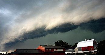
A derecho (/dəˈɹeɪ.t͡ʃoʊ/ ⓘ, from Spanish: derecho [deˈɾetʃo], 'straight') is a widespread, long-lived, straight-line wind storm that is associated with a fast-moving complex of severe thunderstorms referred to as a mesoscale convective system.
Derechos cause hurricane-force winds, heavy rains, and flash floods. In many cases, convection-induced winds take on a bow echo (backward "C") form of squall line, often forming beneath an area of diverging upper tropospheric winds, and in a region of both rich low-level moisture and warm-air advection. Derechos move rapidly in the direction of movement of their associated storms, similar to an outflow boundary (gust front), except that the wind remains sustained for a greater period of time (often increasing in strength after onset), and may reach tornado- and hurricane-force winds. A derecho-producing convective system may remain active for many hours and, occasionally, over multiple days.
A warm-weather phenomenon, derechos mostly occur in summer, especially during June, July, and August in the Northern Hemisphere, or March, April, and May in the Southern Hemisphere, within areas of moderately strong instability and moderately strong vertical wind shear. However, derechos can occur at any time of the year. They are equally likely during day and night times.
Various studies since the 1980s have shed light on the physical processes responsible for the production of widespread damaging winds by thunderstorms. In addition, it has become apparent that the most damaging derechos are associated with particular types of mesoscale convective systems that are self-perpetuating (meaning that the convective systems are not strongly dependent on the larger-scale meteorological processes such as those associated with blizzard-producing winter storms and strong cold fronts). In addition, the term "derecho" sometimes is misapplied to convectively generated wind events that are not particularly well-organized or long-lasting. For these reasons, a more precise, physically based definition of "derecho" has been introduced within the meteorological community.
Derecho comes from the Spanish adjective for "straight" (or "direct"), in contrast with a tornado which is a "twisted" wind. The word was first used in the American Meteorological Journal in 1888 by Gustavus Detlef Hinrichs in a paper describing the phenomenon and based on a significant derecho event that crossed Iowa on 31 July 1877.
Organized areas of thunderstorm activity reinforce pre-existing frontal zones, and can outrun cold fronts. The resultant mesoscale convective system (MCS) often forms at the point of the strongest divergence of the upper-level flow, and new storm cells are developed in the area with the greatest low-level inflow. The convection tends to move east or toward the equator, roughly parallel to low-level thickness lines and usually somewhat to the right of the mean tropospheric flow. When the convection is strongly linear or slightly curved, the MCS is called a squall line, with the strongest winds typically occurring just behind the leading edge of the significant wind shift and pressure rise.
Classic derechos occur with squall lines that contain bow- or spearhead-shaped features as seen by weather radar that are known as bow echoes or spearhead echoes. Squall lines typically "bow out" due to the formation of a mesoscale high-pressure system which forms within the stratiform rain area behind the initial convective line. This high-pressure area is formed due to strong descending air currents behind the squall line, and could come in the form of a downburst. The size of the bow may vary, and the storms associated with the bow may die and redevelop.
During the cool season within the Northern Hemisphere, derechos generally develop within a pattern of mid-tropospheric southwesterly winds, in an environment of low to moderate atmospheric instability (caused by relative warmth and moisture near ground level, with cooler air aloft, as measured by convective available potential energy), and high values of vertical wind shear (20 m/s or 40 knots within the lowest 5 km or 16,000 ft of the atmosphere).
Hub AI
Derecho AI simulator
(@Derecho_simulator)
Derecho
A derecho (/dəˈɹeɪ.t͡ʃoʊ/ ⓘ, from Spanish: derecho [deˈɾetʃo], 'straight') is a widespread, long-lived, straight-line wind storm that is associated with a fast-moving complex of severe thunderstorms referred to as a mesoscale convective system.
Derechos cause hurricane-force winds, heavy rains, and flash floods. In many cases, convection-induced winds take on a bow echo (backward "C") form of squall line, often forming beneath an area of diverging upper tropospheric winds, and in a region of both rich low-level moisture and warm-air advection. Derechos move rapidly in the direction of movement of their associated storms, similar to an outflow boundary (gust front), except that the wind remains sustained for a greater period of time (often increasing in strength after onset), and may reach tornado- and hurricane-force winds. A derecho-producing convective system may remain active for many hours and, occasionally, over multiple days.
A warm-weather phenomenon, derechos mostly occur in summer, especially during June, July, and August in the Northern Hemisphere, or March, April, and May in the Southern Hemisphere, within areas of moderately strong instability and moderately strong vertical wind shear. However, derechos can occur at any time of the year. They are equally likely during day and night times.
Various studies since the 1980s have shed light on the physical processes responsible for the production of widespread damaging winds by thunderstorms. In addition, it has become apparent that the most damaging derechos are associated with particular types of mesoscale convective systems that are self-perpetuating (meaning that the convective systems are not strongly dependent on the larger-scale meteorological processes such as those associated with blizzard-producing winter storms and strong cold fronts). In addition, the term "derecho" sometimes is misapplied to convectively generated wind events that are not particularly well-organized or long-lasting. For these reasons, a more precise, physically based definition of "derecho" has been introduced within the meteorological community.
Derecho comes from the Spanish adjective for "straight" (or "direct"), in contrast with a tornado which is a "twisted" wind. The word was first used in the American Meteorological Journal in 1888 by Gustavus Detlef Hinrichs in a paper describing the phenomenon and based on a significant derecho event that crossed Iowa on 31 July 1877.
Organized areas of thunderstorm activity reinforce pre-existing frontal zones, and can outrun cold fronts. The resultant mesoscale convective system (MCS) often forms at the point of the strongest divergence of the upper-level flow, and new storm cells are developed in the area with the greatest low-level inflow. The convection tends to move east or toward the equator, roughly parallel to low-level thickness lines and usually somewhat to the right of the mean tropospheric flow. When the convection is strongly linear or slightly curved, the MCS is called a squall line, with the strongest winds typically occurring just behind the leading edge of the significant wind shift and pressure rise.
Classic derechos occur with squall lines that contain bow- or spearhead-shaped features as seen by weather radar that are known as bow echoes or spearhead echoes. Squall lines typically "bow out" due to the formation of a mesoscale high-pressure system which forms within the stratiform rain area behind the initial convective line. This high-pressure area is formed due to strong descending air currents behind the squall line, and could come in the form of a downburst. The size of the bow may vary, and the storms associated with the bow may die and redevelop.
During the cool season within the Northern Hemisphere, derechos generally develop within a pattern of mid-tropospheric southwesterly winds, in an environment of low to moderate atmospheric instability (caused by relative warmth and moisture near ground level, with cooler air aloft, as measured by convective available potential energy), and high values of vertical wind shear (20 m/s or 40 knots within the lowest 5 km or 16,000 ft of the atmosphere).
Recent media