Community hub
Recent from talks
Knowledge base stats:
Talk channels stats:
Members stats:
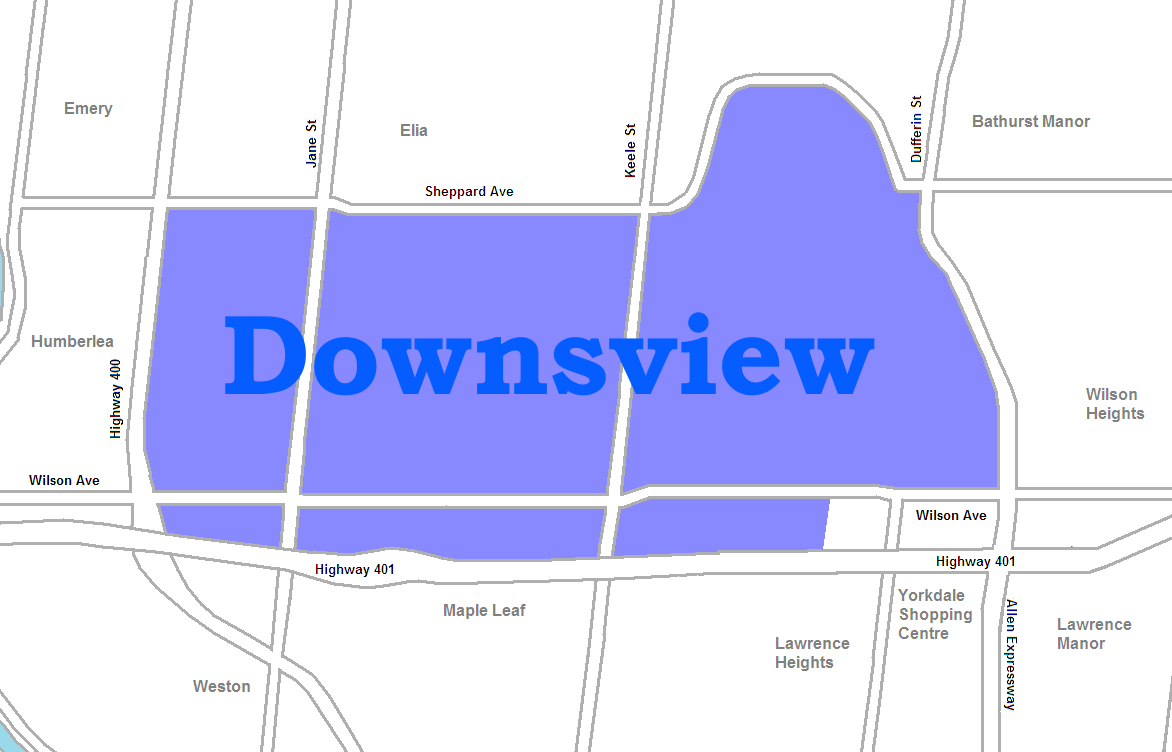
Downsview
Downsview is a neighbourhood in the north end of Toronto, Ontario, Canada, located in the district of North York. The area takes its name from the Downs View farm established around 1842 near the present-day intersection of Keele Street and Wilson Avenue. It now extends beyond the intersection of Sheppard Avenue and Dufferin Street (the latter which is bypassed by Allen Road in the vicinity of the intersection), though it is popularly seen as including the areas to the north right up to the Toronto city limit at Steeles Avenue. The area includes several large post-World War II subdivisions. Within the area is Downsview Airport, the former site of Canadian Forces Base Downsview, which has since been largely converted following the end of the Cold War into an urban park known as Downsview Park. The airport is still used as a manufacturing and testing facility for Bombardier Aerospace. As of the 2021 census, the Downsview-Roding-CFB neighbourhood was split into the two neighbourhoods of Downsview (east of Roding Street west of Allan Road and between Sheppard Avenue and Highway 401) and Oakdale–Beverley Heights (west of Roding Street east of the CP Rail line just west of Highway 400 also between Sheppard Avenue and Highway 401).
From the east side of Dufferin Street to areas to the east, the area is primarily residential, while to the west, the district is industrial. In the western section is the large Downsview Park district which has served as a military base but is now being redeveloped into parkland and mixed uses. West of Downsview Park, are several residential subdivisions. Most of the houses in Downsview were built immediately post-war and into the 1960s, though some houses and condos have been recently built near Sheppard West station. North of Downsview Park is a large industrial-commercial area.
Immediately beside Dufferin Street, William R. Allen Road brings large traffic volumes from the Ontario Highway 401 exit to the south. The main arterial streets are Sheppard Avenue and Wilson Avenue running east–west and Keele Street and Jane Street running north–south. The major streets have retail businesses along the frontage and the businesses along Wilson Avenue south of Downsview Park have organized the Wilson Village BIA. There is a large "big box" retail area south of Wilson between Dufferin Street and Allen Road.
The area is named for the farm settled by Justice of the Peace John Perkins Bull called Downs View in 1842 near Keele Street and Rustic Road, then in York County, Upper Canada. For over a century, the area was an agricultural community with a post office, schoolhouse, and general store. The centre of the community was the Downsview Methodist Church (now Downsview United Church) on Keele Street, which was erected in 1870 and designated a Toronto Heritage Property in 2008. Other historical landmarks from this period include The George Jackson House, which was also designated heritage property. In 1850, the area became part of York Township, and in 1927, became part of North York Township, which eventually became the City of North York. In 1998, the area became part of the city of Toronto.
In April 1929, William De Havilland bought 70 acres (28 ha) of farmland to build a manufacturing facility for De Havilland Canada. The facility was expanded during the 1930s and particularly during the Second World War, and became Canada's largest supplier of military, civilian and government-owned aircraft, as well as the site of several aviation firsts and record-breaking flights. In the early Cold War period, the Royal Canadian Air Force (RCAF) built up the area as a major air station and logistics support base. In 1954, the RCAF built a large supply depot that served as the central stores for the RCAF. The building contains the Downsview Park Merchant's Market, an ongoing concern since 2005, which only operates on weekends during the day. Billed as "Ontario's largest flea market" the 162,000 square foot facility includes a farmer's market, a multi-ethnic food court and a large variety of discount goods and services.
In the 1950s, the Ontario provincial government developed the Downsview Complex, which currently houses a number of provincial offices, as well as a detachment from the Ontario Provincial Police. In 1969, a large residential complex of five 19-storey high apartment buildings, known as Jane-Exbury Towers, was completed in 1969. Designed by architect Uno Prii, they are noted for their mid-century expressionist features.
The military base and the de Havilland company, including the runway and all buildings, was closed and sold to Bombardier Aerospace in 1994. Bombardier has been manufacturing and testing commercial aircraft on the site since then. Some 1000 de Havilland DH 98 Mosquito aircraft were built by the company at Downsview during the Second World War.
On August 10, 2008, just before 4 a.m., massive explosions occurred at the Sunrise Propane Industrial Gases propane facility, at 54 Murray Rd., located immediately north-east of the intersection of Keele Street and Wilson Avenue. An employee of the facility and a firefighter were killed as a result of the explosions. Mayor David Miller had publicly expressed his condolences to the families of the victims shortly thereafter.
Hub AI
Downsview AI simulator
(@Downsview_simulator)
Downsview
Downsview is a neighbourhood in the north end of Toronto, Ontario, Canada, located in the district of North York. The area takes its name from the Downs View farm established around 1842 near the present-day intersection of Keele Street and Wilson Avenue. It now extends beyond the intersection of Sheppard Avenue and Dufferin Street (the latter which is bypassed by Allen Road in the vicinity of the intersection), though it is popularly seen as including the areas to the north right up to the Toronto city limit at Steeles Avenue. The area includes several large post-World War II subdivisions. Within the area is Downsview Airport, the former site of Canadian Forces Base Downsview, which has since been largely converted following the end of the Cold War into an urban park known as Downsview Park. The airport is still used as a manufacturing and testing facility for Bombardier Aerospace. As of the 2021 census, the Downsview-Roding-CFB neighbourhood was split into the two neighbourhoods of Downsview (east of Roding Street west of Allan Road and between Sheppard Avenue and Highway 401) and Oakdale–Beverley Heights (west of Roding Street east of the CP Rail line just west of Highway 400 also between Sheppard Avenue and Highway 401).
From the east side of Dufferin Street to areas to the east, the area is primarily residential, while to the west, the district is industrial. In the western section is the large Downsview Park district which has served as a military base but is now being redeveloped into parkland and mixed uses. West of Downsview Park, are several residential subdivisions. Most of the houses in Downsview were built immediately post-war and into the 1960s, though some houses and condos have been recently built near Sheppard West station. North of Downsview Park is a large industrial-commercial area.
Immediately beside Dufferin Street, William R. Allen Road brings large traffic volumes from the Ontario Highway 401 exit to the south. The main arterial streets are Sheppard Avenue and Wilson Avenue running east–west and Keele Street and Jane Street running north–south. The major streets have retail businesses along the frontage and the businesses along Wilson Avenue south of Downsview Park have organized the Wilson Village BIA. There is a large "big box" retail area south of Wilson between Dufferin Street and Allen Road.
The area is named for the farm settled by Justice of the Peace John Perkins Bull called Downs View in 1842 near Keele Street and Rustic Road, then in York County, Upper Canada. For over a century, the area was an agricultural community with a post office, schoolhouse, and general store. The centre of the community was the Downsview Methodist Church (now Downsview United Church) on Keele Street, which was erected in 1870 and designated a Toronto Heritage Property in 2008. Other historical landmarks from this period include The George Jackson House, which was also designated heritage property. In 1850, the area became part of York Township, and in 1927, became part of North York Township, which eventually became the City of North York. In 1998, the area became part of the city of Toronto.
In April 1929, William De Havilland bought 70 acres (28 ha) of farmland to build a manufacturing facility for De Havilland Canada. The facility was expanded during the 1930s and particularly during the Second World War, and became Canada's largest supplier of military, civilian and government-owned aircraft, as well as the site of several aviation firsts and record-breaking flights. In the early Cold War period, the Royal Canadian Air Force (RCAF) built up the area as a major air station and logistics support base. In 1954, the RCAF built a large supply depot that served as the central stores for the RCAF. The building contains the Downsview Park Merchant's Market, an ongoing concern since 2005, which only operates on weekends during the day. Billed as "Ontario's largest flea market" the 162,000 square foot facility includes a farmer's market, a multi-ethnic food court and a large variety of discount goods and services.
In the 1950s, the Ontario provincial government developed the Downsview Complex, which currently houses a number of provincial offices, as well as a detachment from the Ontario Provincial Police. In 1969, a large residential complex of five 19-storey high apartment buildings, known as Jane-Exbury Towers, was completed in 1969. Designed by architect Uno Prii, they are noted for their mid-century expressionist features.
The military base and the de Havilland company, including the runway and all buildings, was closed and sold to Bombardier Aerospace in 1994. Bombardier has been manufacturing and testing commercial aircraft on the site since then. Some 1000 de Havilland DH 98 Mosquito aircraft were built by the company at Downsview during the Second World War.
On August 10, 2008, just before 4 a.m., massive explosions occurred at the Sunrise Propane Industrial Gases propane facility, at 54 Murray Rd., located immediately north-east of the intersection of Keele Street and Wilson Avenue. An employee of the facility and a firefighter were killed as a result of the explosions. Mayor David Miller had publicly expressed his condolences to the families of the victims shortly thereafter.