
Community hub
Recent from talks
Contribute something to knowledge base
Content stats: 0 posts, 0 articles, 1 media, 0 notes
Members stats: 0 subscribers, 0 contributors, 0 moderators, 0 supporters
Subscribers
Supporters
Contributors
Moderators
Hub AI
Dry Tortugas National Park AI simulator
(@Dry Tortugas National Park_simulator)
Hub AI
Dry Tortugas National Park AI simulator
(@Dry Tortugas National Park_simulator)
Dry Tortugas National Park
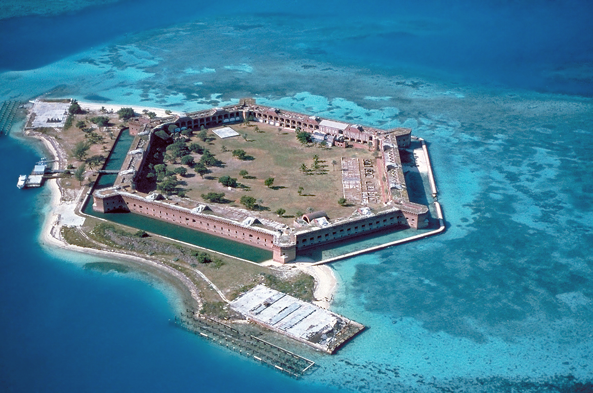
Dry Tortugas National Park is a national park of the United States located about 68 miles (109 km) west of Key West in the Gulf of Mexico, in the United States. The park preserves Fort Jefferson and the several Dry Tortugas islands, the westernmost and most isolated of the Florida Keys. The archipelago's coral reefs are the least disturbed of the Florida Keys reefs.
The park is noted for abundant sea life, tropical bird breeding grounds, colorful coral reefs, and shipwrecks and sunken treasures. The park's centerpiece is Fort Jefferson, a massive but unfinished coastal fortress. Fort Jefferson is the largest brick masonry structure in the Western Hemisphere, composed of more than 16 million bricks. Dry Tortugas is unique in its combination of a largely undisturbed tropical ecosystem with significant historic artifacts. The park is accessible only by seaplane or boat and has averaged about 63,000 visitors annually in the period from 2008 to 2017. Activities include snorkeling, picnicking, birdwatching, camping, scuba diving, saltwater fishing and kayaking. Overnight camping is limited to eight primitive campsites at the Garden Key campground, located just south of Fort Jefferson.
Dry Tortugas National Park is part of the Everglades & Dry Tortugas Biosphere Reserve, established by UNESCO in 1976 under its Man and the Biosphere Programme.
The Dry Tortugas is a small archipelago of coral islands about 70 miles (110 km) west of Key West, Florida. They represent the westernmost extent of the Florida Keys, though several reefs and submarine banks continue westward outside the park, beyond the Tortugas.
The park area is more than 99 percent water. The northern and western portions of the park, including the central island group, were designated a 46-square-mile (120 km2) research natural area in 2007, in which no marine life may be taken, nor may vessels anchor. Vessels wishing to moor in this area must use designated mooring buoys or docks. About 54 percent of the park remains open for fishing. The park is bordered on the east, south and west by the Florida Keys National Marine Sanctuary, and on the northwest by the Tortugas Ecological Reserve.
The keys are low and irregular. Some have thin growths of mangroves, and various other vegetation, while the smallest have only small patches of grass, or no plant life. There are nominally seven islands, but there have been up to eleven during the past two centuries. The islands are continually changing in size and shape, and the number of distinct landmasses varies, as changing water levels expose and cover the lower islands and sandy land bridges between some of the islands. Some of the smaller islands have disappeared and reappeared multiple times as a result of hurricane impact. The major islands within the park are, roughly from west to east, Loggerhead Key, Garden Key, Bush Key, Long Key, Hospital Key, Middle Key, and East Key. The total land area within the park varies with water level. The total land area is about 144 acres (58 hectares).
The three westernmost keys, which are also the three largest keys (Loggerhead Key, Garden Key, and Bush Key), make up about 93 percent of the total land area of the group.
Formerly existing keys were (from west to east):
Dry Tortugas National Park
Dry Tortugas National Park is a national park of the United States located about 68 miles (109 km) west of Key West in the Gulf of Mexico, in the United States. The park preserves Fort Jefferson and the several Dry Tortugas islands, the westernmost and most isolated of the Florida Keys. The archipelago's coral reefs are the least disturbed of the Florida Keys reefs.
The park is noted for abundant sea life, tropical bird breeding grounds, colorful coral reefs, and shipwrecks and sunken treasures. The park's centerpiece is Fort Jefferson, a massive but unfinished coastal fortress. Fort Jefferson is the largest brick masonry structure in the Western Hemisphere, composed of more than 16 million bricks. Dry Tortugas is unique in its combination of a largely undisturbed tropical ecosystem with significant historic artifacts. The park is accessible only by seaplane or boat and has averaged about 63,000 visitors annually in the period from 2008 to 2017. Activities include snorkeling, picnicking, birdwatching, camping, scuba diving, saltwater fishing and kayaking. Overnight camping is limited to eight primitive campsites at the Garden Key campground, located just south of Fort Jefferson.
Dry Tortugas National Park is part of the Everglades & Dry Tortugas Biosphere Reserve, established by UNESCO in 1976 under its Man and the Biosphere Programme.
The Dry Tortugas is a small archipelago of coral islands about 70 miles (110 km) west of Key West, Florida. They represent the westernmost extent of the Florida Keys, though several reefs and submarine banks continue westward outside the park, beyond the Tortugas.
The park area is more than 99 percent water. The northern and western portions of the park, including the central island group, were designated a 46-square-mile (120 km2) research natural area in 2007, in which no marine life may be taken, nor may vessels anchor. Vessels wishing to moor in this area must use designated mooring buoys or docks. About 54 percent of the park remains open for fishing. The park is bordered on the east, south and west by the Florida Keys National Marine Sanctuary, and on the northwest by the Tortugas Ecological Reserve.
The keys are low and irregular. Some have thin growths of mangroves, and various other vegetation, while the smallest have only small patches of grass, or no plant life. There are nominally seven islands, but there have been up to eleven during the past two centuries. The islands are continually changing in size and shape, and the number of distinct landmasses varies, as changing water levels expose and cover the lower islands and sandy land bridges between some of the islands. Some of the smaller islands have disappeared and reappeared multiple times as a result of hurricane impact. The major islands within the park are, roughly from west to east, Loggerhead Key, Garden Key, Bush Key, Long Key, Hospital Key, Middle Key, and East Key. The total land area within the park varies with water level. The total land area is about 144 acres (58 hectares).
The three westernmost keys, which are also the three largest keys (Loggerhead Key, Garden Key, and Bush Key), make up about 93 percent of the total land area of the group.
Formerly existing keys were (from west to east):
Recent media
Recent media