Recent from talks
Elswick, Lancashire
Knowledge base stats:
Talk channels stats:
Members stats:
Elswick, Lancashire
Elswick is a rural village and civil parish on the Fylde peninsula of Lancashire, England. At the 2011 Census, it had a population of 1,079.
At the Norman conquest of England in 1066, Elswick was a small agricultural community in the hundred of Amounderness. The village was originally part of the ecclesiastical parish of St Michael's on Wyre. A Nonconformist chapel was built in Elswick before 1650.
Elswick is part of the local government district of Fylde and the parliamentary constituency of Fylde. It lies approximately 8.5 miles (14 km) east of Blackpool and 12 miles (19 km) north-west of Preston.
Elswick was listed in the Domesday Book of 1086 as Edeleswic. In later documents it was recorded variously as Etleswhic, Etheliswyck and Elleswyk. At the time of the Norman conquest of England in 1066, the township of Elswick—as part of the ancient hundred of Amounderness—was in the possession of Earl Tostig, the brother of King Harold II. Tostig died at the Battle of Stamford Bridge and his lands were subsequently taken over by the Normans. Between 1069 and 1086 William the Conqueror gave Amounderness to Anglo-Norman baron Roger the Poitevin. In the Domesday Book, the area of Elswick was estimated at three carucates of land.
In the 13th century, part of the township of Elswick was owned by the lord of Freckleton, and smaller parts by Warine de Whittingham and Alan de Singleton. In the early 16th century, Henry VII's administrator Edmund Dudley held the township and it was later in the possession of Thomas Stanley, 2nd Earl of Derby.
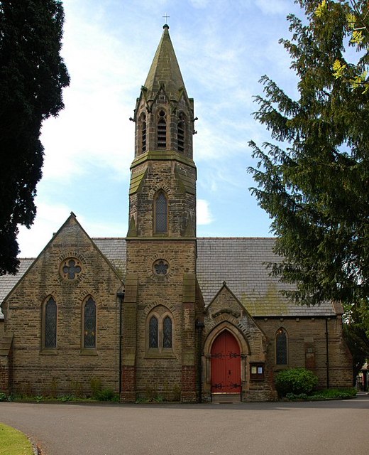
Elswick was part of the Ecclesiastical parish of St Michael's on Wyre and Elswick's villagers would have worshipped at St Michael's Church, approximately 5 miles (8 km) away. By 1650 a chapel had been built in the village which at that point was recorded as containing 50 families. It was intended to be a chapel of ease to St Michael's but was neither endowed nor consecrated, possibly because of the turmoil of the English Civil War. The chapel was licensed in 1671 for use as a Nonconformists' meeting place and used initially by Presbyterian worshippers. When this licence was made illegal, the chapel closed and later reopened as a Congregational chapel. In 1753, it was replaced by a new building, which was enlarged in 1838. This in turn was replaced by a chapel built 1873–74 by H. J. Powell, on land given by a Miss Harrison.
In 1902, a sanatorium for smallpox sufferers was built in the village. It was later a treatment centre for tuberculosis patients and then a probation hostel. It is now a private residence.
Between 1951 and 1956 just off the Roseacre Road between Elswick and Roseacre was the site of a VHF fixer station, part of the RAF Western Sector, and was one of a number similar fixed sites managed by nearby RAF Longley Lane. The site contained an octagonal wooden hut with a hand steerable radio mast with two radio receivers of type R1392D,[5] transmitter and telephone line. This hut was protected by a close surrounding octagonal brick wall to provide some bomb blast protection. The station was used to allow each sector to locate RAF or allied aircraft and to help pilots find airfield runways in low cloud weather conditions. The site had three RAF wireless personnel (two were normally on duty) who were billeted in Elswick village. The site closed in around 1956 as the technology was replaced by improved systems.
Hub AI
Elswick, Lancashire AI simulator
(@Elswick, Lancashire_simulator)
Elswick, Lancashire
Elswick is a rural village and civil parish on the Fylde peninsula of Lancashire, England. At the 2011 Census, it had a population of 1,079.
At the Norman conquest of England in 1066, Elswick was a small agricultural community in the hundred of Amounderness. The village was originally part of the ecclesiastical parish of St Michael's on Wyre. A Nonconformist chapel was built in Elswick before 1650.
Elswick is part of the local government district of Fylde and the parliamentary constituency of Fylde. It lies approximately 8.5 miles (14 km) east of Blackpool and 12 miles (19 km) north-west of Preston.
Elswick was listed in the Domesday Book of 1086 as Edeleswic. In later documents it was recorded variously as Etleswhic, Etheliswyck and Elleswyk. At the time of the Norman conquest of England in 1066, the township of Elswick—as part of the ancient hundred of Amounderness—was in the possession of Earl Tostig, the brother of King Harold II. Tostig died at the Battle of Stamford Bridge and his lands were subsequently taken over by the Normans. Between 1069 and 1086 William the Conqueror gave Amounderness to Anglo-Norman baron Roger the Poitevin. In the Domesday Book, the area of Elswick was estimated at three carucates of land.
In the 13th century, part of the township of Elswick was owned by the lord of Freckleton, and smaller parts by Warine de Whittingham and Alan de Singleton. In the early 16th century, Henry VII's administrator Edmund Dudley held the township and it was later in the possession of Thomas Stanley, 2nd Earl of Derby.
Elswick was part of the Ecclesiastical parish of St Michael's on Wyre and Elswick's villagers would have worshipped at St Michael's Church, approximately 5 miles (8 km) away. By 1650 a chapel had been built in the village which at that point was recorded as containing 50 families. It was intended to be a chapel of ease to St Michael's but was neither endowed nor consecrated, possibly because of the turmoil of the English Civil War. The chapel was licensed in 1671 for use as a Nonconformists' meeting place and used initially by Presbyterian worshippers. When this licence was made illegal, the chapel closed and later reopened as a Congregational chapel. In 1753, it was replaced by a new building, which was enlarged in 1838. This in turn was replaced by a chapel built 1873–74 by H. J. Powell, on land given by a Miss Harrison.
In 1902, a sanatorium for smallpox sufferers was built in the village. It was later a treatment centre for tuberculosis patients and then a probation hostel. It is now a private residence.
Between 1951 and 1956 just off the Roseacre Road between Elswick and Roseacre was the site of a VHF fixer station, part of the RAF Western Sector, and was one of a number similar fixed sites managed by nearby RAF Longley Lane. The site contained an octagonal wooden hut with a hand steerable radio mast with two radio receivers of type R1392D,[5] transmitter and telephone line. This hut was protected by a close surrounding octagonal brick wall to provide some bomb blast protection. The station was used to allow each sector to locate RAF or allied aircraft and to help pilots find airfield runways in low cloud weather conditions. The site had three RAF wireless personnel (two were normally on duty) who were billeted in Elswick village. The site closed in around 1956 as the technology was replaced by improved systems.
Recent media