Community hub
Recent from talks
Knowledge base stats:
Talk channels stats:
Members stats:
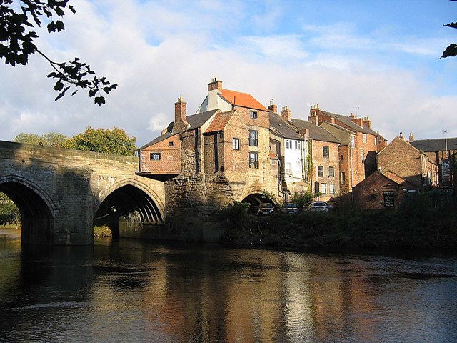
Elvet
Elvet is an area of the city of Durham, in County Durham, England. It is situated on the opposite side of the River Wear from Durham Cathedral and forms the south-eastern part of central Durham.
The name Elvet is recorded as Aelfetee in circa 800 AD and in the 12th century as Aeluete and Eluete. It is thought to be Old English in origin, containing the element elfitu ("a swan") + either ēa ("a river") or ēg ("an island"), giving the name a meaning of "swan stream" or "swan island". The Swan and Three Cygnets, a public house on Elvet Bridge, is a reminder of the historical name given to this part of the city.
Other attempts at the etymology of Elvet include identification with the epithet Elfed in the name of Madog, a hero in Y Gododdin.
Elvet grew up from two medieval settlements based around Old Elvet and St Oswald's Church and includes Church Street, Hallgarth Street, Whinney Hill and the Roman Catholic St Cuthbert's Church. Elvet is home to Durham Prison and Durham Crown Court centre (Court Lane), County Court centre (New Elvet) and magistrates' court (Old Elvet). The Crown Court centre was originally built for the Durham Assizes and is a grade II* listed building.
Elvet was chartered by Prior Bertram of Durham in 1188–1208 and was an ancient borough until 1835, when it became a township in the civil parish of St Oswald, within the municipal borough of Durham. In 1866 Elvet became a separate civil parish within the borough; on 1 April 1916 the civil parish was abolished and Elvet became a ward of Durham. In 1911 the parish had a population of 3934. The 1919 25 inch to 1 mile Ordnance Survey maps show the Elvet ward boundary as running northeast along a stream from the Quarryheads Lane – Potters Bank junction to the River Wear and then along the centre of the river to join the municipal borough boundary where this came down to the river at Pelaw Woods, then following the municipal borough boundary along the river to Shincliffe Bridge and then along Stockton Road and Quarryheads Lane back to the junction with Potters Bank.
Elvet forms one of the character areas of Durham City conservation area. The Elvet character area is bounded by the River Wear to the west and north, the scarp slopes to the east and the road to Mountjoy Farm and Stockton Road to the south, as and extends along both sides of Quarryheads Lane as far as the Potters Bank roundabout, taking in the built up area of Elvet and surrounding countryside, including the Racecourse, Maiden Castle and Mount Joy hill. Since 2018, Elvet has been part of the Elvet and Gilesgate ward of the City of Durham parish. The south and east boundaries of the ward are similar to those of the character area, although excluding Mount Joy hill; as the ward takes in Crossgate, the Peninsular, Claypath and part of Gilesgate, the north and west boundaries lie beyond Elvet.
Elvet House, a former Crown building (c. 1951) in Hallgarth Street, is currently the base for Durham's Jobcentre Plus, Crown Prosecution Service, Driving Standards Agency and Tribunals Service. The County Court vacated its purpose-built 1960's annex to Elvet House in October 2008 to relocate alongside the magistrates' court.
The former priory farm included the former granary called the Tithe Barn, which is grade II* listed; and two former barns, other buildings and a wall which are grade II listed. The Tithe Barn has been dated between 1446 and 1449.
Hub AI
Elvet AI simulator
(@Elvet_simulator)
Elvet
Elvet is an area of the city of Durham, in County Durham, England. It is situated on the opposite side of the River Wear from Durham Cathedral and forms the south-eastern part of central Durham.
The name Elvet is recorded as Aelfetee in circa 800 AD and in the 12th century as Aeluete and Eluete. It is thought to be Old English in origin, containing the element elfitu ("a swan") + either ēa ("a river") or ēg ("an island"), giving the name a meaning of "swan stream" or "swan island". The Swan and Three Cygnets, a public house on Elvet Bridge, is a reminder of the historical name given to this part of the city.
Other attempts at the etymology of Elvet include identification with the epithet Elfed in the name of Madog, a hero in Y Gododdin.
Elvet grew up from two medieval settlements based around Old Elvet and St Oswald's Church and includes Church Street, Hallgarth Street, Whinney Hill and the Roman Catholic St Cuthbert's Church. Elvet is home to Durham Prison and Durham Crown Court centre (Court Lane), County Court centre (New Elvet) and magistrates' court (Old Elvet). The Crown Court centre was originally built for the Durham Assizes and is a grade II* listed building.
Elvet was chartered by Prior Bertram of Durham in 1188–1208 and was an ancient borough until 1835, when it became a township in the civil parish of St Oswald, within the municipal borough of Durham. In 1866 Elvet became a separate civil parish within the borough; on 1 April 1916 the civil parish was abolished and Elvet became a ward of Durham. In 1911 the parish had a population of 3934. The 1919 25 inch to 1 mile Ordnance Survey maps show the Elvet ward boundary as running northeast along a stream from the Quarryheads Lane – Potters Bank junction to the River Wear and then along the centre of the river to join the municipal borough boundary where this came down to the river at Pelaw Woods, then following the municipal borough boundary along the river to Shincliffe Bridge and then along Stockton Road and Quarryheads Lane back to the junction with Potters Bank.
Elvet forms one of the character areas of Durham City conservation area. The Elvet character area is bounded by the River Wear to the west and north, the scarp slopes to the east and the road to Mountjoy Farm and Stockton Road to the south, as and extends along both sides of Quarryheads Lane as far as the Potters Bank roundabout, taking in the built up area of Elvet and surrounding countryside, including the Racecourse, Maiden Castle and Mount Joy hill. Since 2018, Elvet has been part of the Elvet and Gilesgate ward of the City of Durham parish. The south and east boundaries of the ward are similar to those of the character area, although excluding Mount Joy hill; as the ward takes in Crossgate, the Peninsular, Claypath and part of Gilesgate, the north and west boundaries lie beyond Elvet.
Elvet House, a former Crown building (c. 1951) in Hallgarth Street, is currently the base for Durham's Jobcentre Plus, Crown Prosecution Service, Driving Standards Agency and Tribunals Service. The County Court vacated its purpose-built 1960's annex to Elvet House in October 2008 to relocate alongside the magistrates' court.
The former priory farm included the former granary called the Tithe Barn, which is grade II* listed; and two former barns, other buildings and a wall which are grade II listed. The Tithe Barn has been dated between 1446 and 1449.