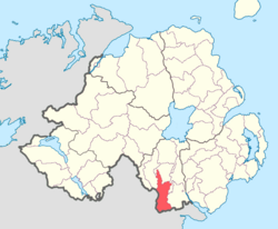
Fews Upper (from Irish na Feá/Feadha, meaning 'the woods')[2] is a barony in County Armagh, Northern Ireland. It lies in the south of the county bordering the Republic of Ireland with its southern and south-western borders. It is bordered by four other baronies in Northern Ireland: Armagh to the west; Fews Lower to the north and west; Orior Lower to the north-west; and Orior Upper to the east.[3] It also borders three baronies in the Republic of Ireland: Cremorne to the west; Dundalk Upper to the south; and Farney to the south-west. Fews Lower and Upper formed the barony of The Fews until it was sub-divided.
The Fews Mountains run through both Fews Lower and Upper, with the range's highest peak, Carrigatuke (also known as Armaghbrague Mountain), standing at 1,200 ft., located in Fews Lower.[4] The County Water and Clarbane River both flow through Fews Upper. The Ballynacarry Bridge crosses the River Fane which is on the border between County Armagh and County Monaghan.[1][5]
Below is a list of settlements in Fews Upper:[1]
Below is a list of civil parishes in Fews Upper:[6]
This article related to the geography of County Armagh, Northern Ireland is a stub. You can help Wikipedia by expanding it. |


