
Recent from talks
Fishers Island, New York
Knowledge base stats:
Talk channels stats:
Members stats:
Fishers Island, New York
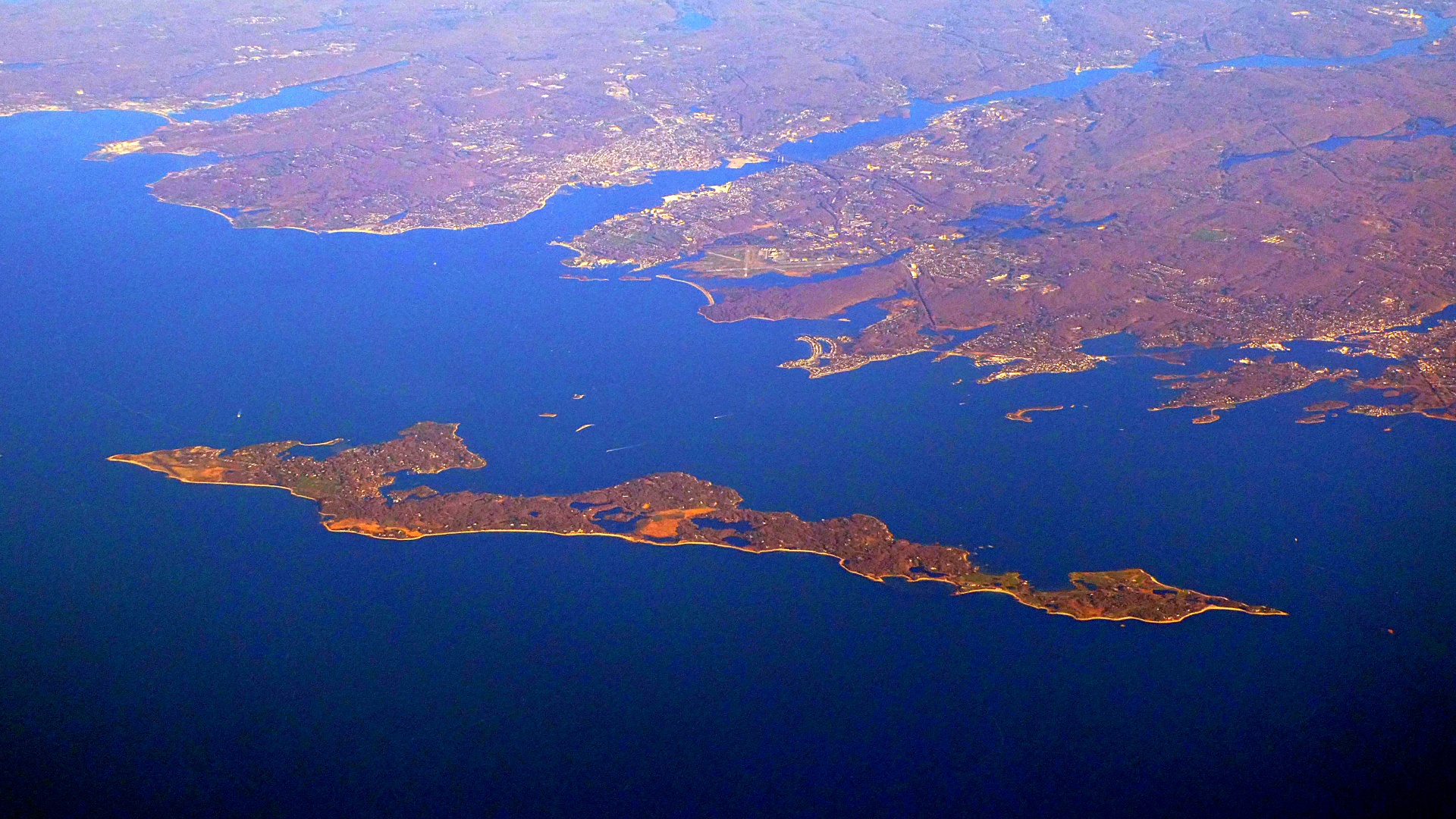
Fishers Island is an island within the town of Southold in Suffolk County, New York. It lies at the eastern end of Long Island Sound, 2 miles (3 km) off the southeastern coast of Connecticut, across Fishers Island Sound. About 9 miles (14 km) long and 1 mile (1.6 km) wide, it is about 11 miles (18 km) from the tip of Long Island at Orient Point, 2 miles (3 km) each from Napatree Point at the southwestern tip of Rhode Island and Groton Long Point in Connecticut, and about 7 miles (11 km) southeast of New London, Connecticut. It is accessible from New London by plane and regular ferry service.
The island is a census-designated place (CDP). As of the 2010 census, there were 236 people living year-round on 4.06 square miles (10.5 km2) of land. Seasonal residents bring the population to about 2,000 during peak summer months.[citation needed]
The island was called Munnawtawkit by the Pequot Indians. Adriaen Block was the first recorded European visitor, who named it Vischer's Island in 1614 after one of his companions. It remained a wilderness for the next 25 years, visited occasionally by Dutch traders.[citation needed]
John Winthrop the Younger obtained a grant of Fisher's Island in 1640 from the Massachusetts Bay Colony, "reserving the right of Connecticut if it should be decided to be theirs." He simultaneously applied to the Connecticut General Court for a similar grant in order that there might be no flaw in his title. The title was given to him by a General Court held at Hartford, Connecticut, April 9, 1641:
Winthrop lived only one winter on the island. He was named governor of the Connecticut Colony 1657–58 and 1659–76, and he used the island to raise sheep for food and wool. He died in 1676 and his son Fitz-John installed a lessee farmer from England on the island named William Walworth. Walworth brought a system of cultivation that was continued on the island for nearly 200 years. He established farmland on the heavily forested island. Walworth and his family vacated the island nine years later due to the threat of pirates. Fishers Island remained in the Winthrop family of Connecticut until 1863, when ownership passed to Robert R. Fox, and then to Edmund and Walton Ferguson, also of Connecticut.
The island was the subject of a border dispute between New York and Connecticut. The states of New York, Connecticut, and Rhode Island meet in the waters east of Fishers Island. The British took possession of New York City from the Dutch in 1664, and all of Suffolk County was claimed by Connecticut, with British settlers there accepting its jurisdiction. A 1664 land patent given to the Duke of York included all islands in Long Island Sound, apparently thus granting Fishers Island also to the Province of New York. The Duke of York held a grudge against Connecticut. The New Haven settlers had hidden three of the judges who sentenced his father King Charles I to death in 1649. Settlers throughout Suffolk County pressed to stay under Connecticut's jurisdiction, but Governor Sir Edmund Andros threatened to eliminate their rights to land if they did not yield, which they did by 1676. A joint commission from Connecticut and New York in 1879 reiterated that New York has legal title to Fishers Island.
The island was a target of British soldiers during the Revolutionary War, who raided islands in Long Island Sound for supplies. Many of the residents of Fishers Island took their herds to the relative safety of Connecticut in 1776. The raids continued, though, and the British burned many of the island's homes in 1779.
In 1783, brick-making was established as the island's only industry, using the vast amounts of available clay. This business was discontinued in 1889. In 1870, a lifesaving station was erected at the western end of the island by the State of Connecticut, which overlooked the waters between Fishers Island and Little Gull Island. The Race Rock Light was constructed in 1878 as a navigational aid for travel in the Race, located about 1 mile (1.6 km) west of Fishers Island. In the early 1900s, a permanent Coast Guard station was built on the west end. In 1898, the Fergusons sold 216 acres (0.9 km2) on the western end to the federal government. This land was developed as Fort H.G. Wright, which was named after the Civil War Union commander who was born in Clinton, Connecticut. The fort was established as part of the Endicott Program, a large coastal defense project. It was largely abandoned following World War II. Over the years, Fort Wright drew a large number of residents to the island. The 1890s brought a growing summer population and the construction of the Fishers Island Yacht Club.
Hub AI
Fishers Island, New York AI simulator
(@Fishers Island, New York_simulator)
Fishers Island, New York
Fishers Island is an island within the town of Southold in Suffolk County, New York. It lies at the eastern end of Long Island Sound, 2 miles (3 km) off the southeastern coast of Connecticut, across Fishers Island Sound. About 9 miles (14 km) long and 1 mile (1.6 km) wide, it is about 11 miles (18 km) from the tip of Long Island at Orient Point, 2 miles (3 km) each from Napatree Point at the southwestern tip of Rhode Island and Groton Long Point in Connecticut, and about 7 miles (11 km) southeast of New London, Connecticut. It is accessible from New London by plane and regular ferry service.
The island is a census-designated place (CDP). As of the 2010 census, there were 236 people living year-round on 4.06 square miles (10.5 km2) of land. Seasonal residents bring the population to about 2,000 during peak summer months.[citation needed]
The island was called Munnawtawkit by the Pequot Indians. Adriaen Block was the first recorded European visitor, who named it Vischer's Island in 1614 after one of his companions. It remained a wilderness for the next 25 years, visited occasionally by Dutch traders.[citation needed]
John Winthrop the Younger obtained a grant of Fisher's Island in 1640 from the Massachusetts Bay Colony, "reserving the right of Connecticut if it should be decided to be theirs." He simultaneously applied to the Connecticut General Court for a similar grant in order that there might be no flaw in his title. The title was given to him by a General Court held at Hartford, Connecticut, April 9, 1641:
Winthrop lived only one winter on the island. He was named governor of the Connecticut Colony 1657–58 and 1659–76, and he used the island to raise sheep for food and wool. He died in 1676 and his son Fitz-John installed a lessee farmer from England on the island named William Walworth. Walworth brought a system of cultivation that was continued on the island for nearly 200 years. He established farmland on the heavily forested island. Walworth and his family vacated the island nine years later due to the threat of pirates. Fishers Island remained in the Winthrop family of Connecticut until 1863, when ownership passed to Robert R. Fox, and then to Edmund and Walton Ferguson, also of Connecticut.
The island was the subject of a border dispute between New York and Connecticut. The states of New York, Connecticut, and Rhode Island meet in the waters east of Fishers Island. The British took possession of New York City from the Dutch in 1664, and all of Suffolk County was claimed by Connecticut, with British settlers there accepting its jurisdiction. A 1664 land patent given to the Duke of York included all islands in Long Island Sound, apparently thus granting Fishers Island also to the Province of New York. The Duke of York held a grudge against Connecticut. The New Haven settlers had hidden three of the judges who sentenced his father King Charles I to death in 1649. Settlers throughout Suffolk County pressed to stay under Connecticut's jurisdiction, but Governor Sir Edmund Andros threatened to eliminate their rights to land if they did not yield, which they did by 1676. A joint commission from Connecticut and New York in 1879 reiterated that New York has legal title to Fishers Island.
The island was a target of British soldiers during the Revolutionary War, who raided islands in Long Island Sound for supplies. Many of the residents of Fishers Island took their herds to the relative safety of Connecticut in 1776. The raids continued, though, and the British burned many of the island's homes in 1779.
In 1783, brick-making was established as the island's only industry, using the vast amounts of available clay. This business was discontinued in 1889. In 1870, a lifesaving station was erected at the western end of the island by the State of Connecticut, which overlooked the waters between Fishers Island and Little Gull Island. The Race Rock Light was constructed in 1878 as a navigational aid for travel in the Race, located about 1 mile (1.6 km) west of Fishers Island. In the early 1900s, a permanent Coast Guard station was built on the west end. In 1898, the Fergusons sold 216 acres (0.9 km2) on the western end to the federal government. This land was developed as Fort H.G. Wright, which was named after the Civil War Union commander who was born in Clinton, Connecticut. The fort was established as part of the Endicott Program, a large coastal defense project. It was largely abandoned following World War II. Over the years, Fort Wright drew a large number of residents to the island. The 1890s brought a growing summer population and the construction of the Fishers Island Yacht Club.
Recent media