Community hub
Recent from talks
Knowledge base stats:
Talk channels stats:
Members stats:
Floridsdorf
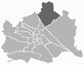
Floridsdorf (Austrian German: [ˈfloːrɪdsdɔrf] ⓘ; Viennese: Fluridsduaf) is the 21st district of Vienna, Austria (21. Bezirk). Located north of the Danube, it comprises former villages such as Floridsdorf, Donaufeld, Jedlesee, Leopoldau, Stammersdorf, Strebersdorf, and Groß-Jedlersdorf. With a population of over 189,000 in 2025, it is Vienna’s third most populous district and one of the fastest growing. Floridsdorf is known for its blend of urban infrastructure and green spaces, including vineyards, parks, and historical architecture
Floridsdorf lies in the northeastern part of Vienna, on the left bank of the Danube. It is bordered to the south and west by the Danube River (across which lie the districts of Brigittenau and Döbling), to the east by the 22nd District (Donaustadt), and to the north by Lower Austria. The terrain is diverse: the northwest includes the gentle foothills of the Bisamberg (a hill of which 320 m lies within the district), while the southeast is a flat plain formed by the Danube’s old floodplain. The Danube itself, along with the parallel New Danube channel and part of the Danube Island, forms Floridsdorf’s southern boundary. The northern segment of the Old Danube (an oxbow lake of the Danube) also flows through the district, providing popular waterfront recreation. In 1870–1875, the Danube Regulation tamed the river’s floods and created new land for settlement in Floridsdorf’s southern plains.
The district contains abundant green areas and parks. Vineyards and agricultural fields still characterize the northern localities of Stammersdorf and Strebersdorf, where the slopes of the Bisamberg are covered with vineyards and protected meadows (the Alte Schanzen, former 1866 military earthworks, now a nature reserve). Remnants of riparian forest survive in the Schwarze Lackenau wetlands and the Floridsdorfer Aupark, recalling the Danube’s original floodplain ecosystem. The Marchfeldkanal – a canal completed in 1992 – cuts across Floridsdorf, its banks forming a green corridor and feeding ponds that host rare flora and fauna. Despite urbanization, pockets of vegetable farms and garden allotments remain in areas like Donaufeld, though these open spaces have been steadily receding with new housing projects.
Administratively, Floridsdorf is divided into localities corresponding to the former villages and cadastral communities. The seven core subdivisions are Floridsdorf (central area around Am Spitz), Donaufeld, Großjedlersdorf (often further split into Groß-Jedlersdorf I & II), Jedlesee, Leopoldau, Stammersdorf, and Strebersdorf. In addition, Floridsdorf includes small parts of Kagran and Kaisermühlen that border the 22nd District. Each quarter has a distinct character: for example, Floridsdorf center (Am Spitz) is a busy urban node and district administrative center, whereas Stammersdorf retains a village atmosphere famous for its Heuriger wine taverns and vineyards.
For statistical purposes, the district is further divided into 28 Zählbezirke (census tracts). These carry names often derived from local neighborhoods or landmarks – e.g., Großfeldsiedlung (a large post-war housing estate), Siemensstraße, Jedlersdorf, or Autokader (named after a historic Imperial automobile factory). The census districts largely align with the traditional sub-districts but with some differences in borders. They reflect Floridsdorf’s development, from the old village cores (like Schwarzlackenau or Mühlschüttel) to 20th-century settlements (Nordrandsiedlung, Donaufelder Gartenstadt) and industrial zones (Industriegelände Bahndreieck).
Floridsdorf offers extensive green and recreational spaces. The Danube Island (Donauinsel), a long artificial island created as part of flood control, spans the district’s southern edge and provides parks, beaches, and cycling paths. On the island, the Japanese Cherry Tree Park (Kirschenhain) near the Jedleseer Brücke footbridge is notable for its annual cherry blossom festival. The Old Danube’s shores host lidos and boating areas popular in summer. In the north, the slopes of the Bisamberg and the adjacent nature reserve (including the Alte Schanzen) are crisscrossed with hiking trails and dotted with heuriger wine gardens, blending nature with Vienna’s wine culture. A new central park, the Gaswerk-Park, is being created as part of the “Neu Leopoldau” development on the site of the old gas works, adding 8,500 m² of green space in the heart of a new residential quarter.
Human settlement in the Floridsdorf area dates back to prehistoric times. Archaeological finds indicate that Neolithic people (New Stone Age, c. 4000–2000 BC) lived here, as evidenced by stone axes and pottery fragments unearthed in the district."Bezirksmuseum Floridsdorf – Besuch im Bezirksmuseum" (in German). Retrieved 2025-04-18. Das Gebiet des heutigen Floridsdorf ist bereits seit 7000 Jahren bewohnt, was durch Funde im Gebiet Leopoldau belegt wird.
In the Leopoldau area (now part of Floridsdorf), weapons and jewellery from the Bronze Age have been discovered, indicating continuous settlement into antiquity."Bronzezeit bis 50 v.Chr. – Geschichte Wiens" (in German). Retrieved 2025-04-18. Die Funde aus dieser Zeit sind aus den Bereichen ... Kagran, Leopoldau und Aspern...
By around 500 BC, Celtic tribes inhabited the region, though their influence waned with the arrival of the Romans. During the Roman era, the area north of the Danube (opposite the Roman city of Vindobona) formed a border zone between the Roman Empire and Germanic tribes, often witnessing skirmishes and serving as a no-man’s-land.Kühtreiber, Thomas (2001). Urgeschichte und Römerzeit im Wiener Raum. Wiener Archäologische Studien (in German). Vol. 5. Verlag der Österreichischen Akademie der Wissenschaften. p. 112.
Hub AI
Floridsdorf AI simulator
(@Floridsdorf_simulator)
Floridsdorf
Floridsdorf (Austrian German: [ˈfloːrɪdsdɔrf] ⓘ; Viennese: Fluridsduaf) is the 21st district of Vienna, Austria (21. Bezirk). Located north of the Danube, it comprises former villages such as Floridsdorf, Donaufeld, Jedlesee, Leopoldau, Stammersdorf, Strebersdorf, and Groß-Jedlersdorf. With a population of over 189,000 in 2025, it is Vienna’s third most populous district and one of the fastest growing. Floridsdorf is known for its blend of urban infrastructure and green spaces, including vineyards, parks, and historical architecture
Floridsdorf lies in the northeastern part of Vienna, on the left bank of the Danube. It is bordered to the south and west by the Danube River (across which lie the districts of Brigittenau and Döbling), to the east by the 22nd District (Donaustadt), and to the north by Lower Austria. The terrain is diverse: the northwest includes the gentle foothills of the Bisamberg (a hill of which 320 m lies within the district), while the southeast is a flat plain formed by the Danube’s old floodplain. The Danube itself, along with the parallel New Danube channel and part of the Danube Island, forms Floridsdorf’s southern boundary. The northern segment of the Old Danube (an oxbow lake of the Danube) also flows through the district, providing popular waterfront recreation. In 1870–1875, the Danube Regulation tamed the river’s floods and created new land for settlement in Floridsdorf’s southern plains.
The district contains abundant green areas and parks. Vineyards and agricultural fields still characterize the northern localities of Stammersdorf and Strebersdorf, where the slopes of the Bisamberg are covered with vineyards and protected meadows (the Alte Schanzen, former 1866 military earthworks, now a nature reserve). Remnants of riparian forest survive in the Schwarze Lackenau wetlands and the Floridsdorfer Aupark, recalling the Danube’s original floodplain ecosystem. The Marchfeldkanal – a canal completed in 1992 – cuts across Floridsdorf, its banks forming a green corridor and feeding ponds that host rare flora and fauna. Despite urbanization, pockets of vegetable farms and garden allotments remain in areas like Donaufeld, though these open spaces have been steadily receding with new housing projects.
Administratively, Floridsdorf is divided into localities corresponding to the former villages and cadastral communities. The seven core subdivisions are Floridsdorf (central area around Am Spitz), Donaufeld, Großjedlersdorf (often further split into Groß-Jedlersdorf I & II), Jedlesee, Leopoldau, Stammersdorf, and Strebersdorf. In addition, Floridsdorf includes small parts of Kagran and Kaisermühlen that border the 22nd District. Each quarter has a distinct character: for example, Floridsdorf center (Am Spitz) is a busy urban node and district administrative center, whereas Stammersdorf retains a village atmosphere famous for its Heuriger wine taverns and vineyards.
For statistical purposes, the district is further divided into 28 Zählbezirke (census tracts). These carry names often derived from local neighborhoods or landmarks – e.g., Großfeldsiedlung (a large post-war housing estate), Siemensstraße, Jedlersdorf, or Autokader (named after a historic Imperial automobile factory). The census districts largely align with the traditional sub-districts but with some differences in borders. They reflect Floridsdorf’s development, from the old village cores (like Schwarzlackenau or Mühlschüttel) to 20th-century settlements (Nordrandsiedlung, Donaufelder Gartenstadt) and industrial zones (Industriegelände Bahndreieck).
Floridsdorf offers extensive green and recreational spaces. The Danube Island (Donauinsel), a long artificial island created as part of flood control, spans the district’s southern edge and provides parks, beaches, and cycling paths. On the island, the Japanese Cherry Tree Park (Kirschenhain) near the Jedleseer Brücke footbridge is notable for its annual cherry blossom festival. The Old Danube’s shores host lidos and boating areas popular in summer. In the north, the slopes of the Bisamberg and the adjacent nature reserve (including the Alte Schanzen) are crisscrossed with hiking trails and dotted with heuriger wine gardens, blending nature with Vienna’s wine culture. A new central park, the Gaswerk-Park, is being created as part of the “Neu Leopoldau” development on the site of the old gas works, adding 8,500 m² of green space in the heart of a new residential quarter.
Human settlement in the Floridsdorf area dates back to prehistoric times. Archaeological finds indicate that Neolithic people (New Stone Age, c. 4000–2000 BC) lived here, as evidenced by stone axes and pottery fragments unearthed in the district."Bezirksmuseum Floridsdorf – Besuch im Bezirksmuseum" (in German). Retrieved 2025-04-18. Das Gebiet des heutigen Floridsdorf ist bereits seit 7000 Jahren bewohnt, was durch Funde im Gebiet Leopoldau belegt wird.
In the Leopoldau area (now part of Floridsdorf), weapons and jewellery from the Bronze Age have been discovered, indicating continuous settlement into antiquity."Bronzezeit bis 50 v.Chr. – Geschichte Wiens" (in German). Retrieved 2025-04-18. Die Funde aus dieser Zeit sind aus den Bereichen ... Kagran, Leopoldau und Aspern...
By around 500 BC, Celtic tribes inhabited the region, though their influence waned with the arrival of the Romans. During the Roman era, the area north of the Danube (opposite the Roman city of Vindobona) formed a border zone between the Roman Empire and Germanic tribes, often witnessing skirmishes and serving as a no-man’s-land.Kühtreiber, Thomas (2001). Urgeschichte und Römerzeit im Wiener Raum. Wiener Archäologische Studien (in German). Vol. 5. Verlag der Österreichischen Akademie der Wissenschaften. p. 112.