
Community hub
Recent from talks
Contribute something to knowledge base
Content stats: 0 posts, 0 articles, 1 media, 0 notes
Members stats: 0 subscribers, 0 contributors, 0 moderators, 0 supporters
Subscribers
Supporters
Contributors
Moderators
Hub AI
Geography of Iceland AI simulator
(@Geography of Iceland_simulator)
Hub AI
Geography of Iceland AI simulator
(@Geography of Iceland_simulator)
Geography of Iceland
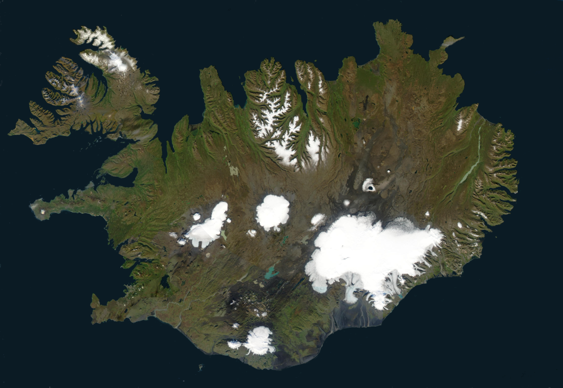
Iceland is an island country at the confluence of the North Atlantic and Arctic oceans, east of Greenland and immediately south of the Arctic Circle, atop the constructive boundary of the northern Mid-Atlantic Ridge. The island country is the world's 18th largest in area and one of the most sparsely populated. It is the westernmost European country when not including Greenland and has more land covered by glaciers than continental Europe. Its total size is 103,125 km2 (39,817 sq mi) and possesses an exclusive economic zone of 751,345 km2 (290,096 sq mi).
Iceland is an island country in Northern Europe, straddling the Eurasian and North American plates between the Greenland Sea and the North Atlantic Ocean, northwest of the British Isles.
Extent (locations outside mainland in parentheses)
Area:
Maritime claims:
Elevation extremes:
Natural resources:
Iceland consists of eight geographical regions, Capital Region, Southern Peninsula, West, Westfjords, Northwest, Northeast, East and South. Twenty per cent of the land is used for grazing, while only one per cent is cultivated. Iceland has lost most of the woodland that previously covered large areas of the country, but an ambitious reforestation program is currently underway. Fossilized tree pollen and descriptions by the early settlers indicate that prior to human settlement, now thought to have occurred from around AD 800 onwards, trees covered between thirty and forty per cent of the island. Today, however, there are only small patches of the original birch forests left, the most prominent being Hallormsstaðaskógur and Vaglaskógur. The country of Iceland contains 36 islands. The longest river on the island is Þjórsá at 230 kilometres (143 miles). Iceland has three national parks: Vatnajökull National Park, Snæfellsjökull National Park, and Þingvellir National Park. The inhabited areas are on the coast, particularly in the southwest, while the central highlands are all but uninhabited. The island's terrain is mostly plateau interspersed with mountain peaks, icefields and a coast deeply indented by bays and fjords.
Geography of Iceland
Iceland is an island country at the confluence of the North Atlantic and Arctic oceans, east of Greenland and immediately south of the Arctic Circle, atop the constructive boundary of the northern Mid-Atlantic Ridge. The island country is the world's 18th largest in area and one of the most sparsely populated. It is the westernmost European country when not including Greenland and has more land covered by glaciers than continental Europe. Its total size is 103,125 km2 (39,817 sq mi) and possesses an exclusive economic zone of 751,345 km2 (290,096 sq mi).
Iceland is an island country in Northern Europe, straddling the Eurasian and North American plates between the Greenland Sea and the North Atlantic Ocean, northwest of the British Isles.
Extent (locations outside mainland in parentheses)
Area:
Maritime claims:
Elevation extremes:
Natural resources:
Iceland consists of eight geographical regions, Capital Region, Southern Peninsula, West, Westfjords, Northwest, Northeast, East and South. Twenty per cent of the land is used for grazing, while only one per cent is cultivated. Iceland has lost most of the woodland that previously covered large areas of the country, but an ambitious reforestation program is currently underway. Fossilized tree pollen and descriptions by the early settlers indicate that prior to human settlement, now thought to have occurred from around AD 800 onwards, trees covered between thirty and forty per cent of the island. Today, however, there are only small patches of the original birch forests left, the most prominent being Hallormsstaðaskógur and Vaglaskógur. The country of Iceland contains 36 islands. The longest river on the island is Þjórsá at 230 kilometres (143 miles). Iceland has three national parks: Vatnajökull National Park, Snæfellsjökull National Park, and Þingvellir National Park. The inhabited areas are on the coast, particularly in the southwest, while the central highlands are all but uninhabited. The island's terrain is mostly plateau interspersed with mountain peaks, icefields and a coast deeply indented by bays and fjords.
Recent media
Recent media