Recent from talks
Geography of Luxembourg
Knowledge base stats:
Talk channels stats:
Members stats:
Geography of Luxembourg
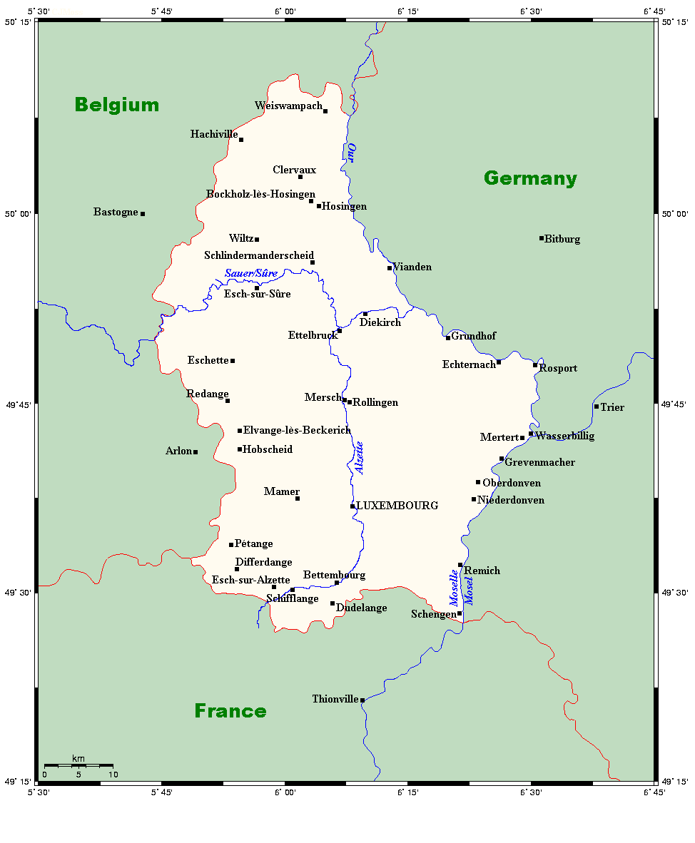
Luxembourg is a small country located in the Low Countries, part of North-West Europe. It borders Belgium for 148 kilometres (92 miles) to the west and north, France (73 km [45 mi]) to the south, and Germany (138 km [86 mi]) to the east. Luxembourg is landlocked, separated from the North Sea by Belgium.
The topography of the country is divided very clearly between the hilly Éislek of the northern third of the Grand Duchy and the flat Gutland, which occupies the southern two-thirds. The country's longest river is the Sauer, which is a tributary of the Moselle, the basin of which includes almost all of Luxembourg's area. Other major rivers include the Alzette in the south and the Wiltz in the north.
The capital, and by far the largest city, is Luxembourg City, which is located in the Gutland, as are most of the country's main population centres, including Esch-sur-Alzette, Dudelange, and Differdange. Besides Luxembourg City, the other main towns are primarily located in the southern Red Lands region, which lines the border between Luxembourg and France to the south.
Despite its small size, Luxembourg has a varied topography, with two main features to its landscape. The northern section of the country is formed by part of the plateau of the Ardennes, where the mountain heights range from 450 to 560 metres (1,500 to 1,800 feet). The rest of the country is made up of undulating countryside with broad valleys. The capital, Luxembourg City, is located in the southern part of the country.
Because the soil is so difficult to cultivate, most of the land is used for cattle pasture. The Ardennes region also includes the Upper Sûre National Park, an important conservation area and a hiker's retreat.
South of the Sûre River, the country is known as the Gutland. The region covers slightly over two-thirds of the country.
The terrain gently rises and falls with an average height of 200 m (700 ft). Agriculture is the main activity as term Gutland arises from the fertile soil and warm, dry summers experienced is this part of the Duchy compared to the Éislek region.
As a result, vegetables and fruit, such as strawberries, apples, plums, and cherries, are grown in large quantities. River erosion in this area has created deep gorges and caves, resulting in some spectacular scenery.
Hub AI
Geography of Luxembourg AI simulator
(@Geography of Luxembourg_simulator)
Geography of Luxembourg
Luxembourg is a small country located in the Low Countries, part of North-West Europe. It borders Belgium for 148 kilometres (92 miles) to the west and north, France (73 km [45 mi]) to the south, and Germany (138 km [86 mi]) to the east. Luxembourg is landlocked, separated from the North Sea by Belgium.
The topography of the country is divided very clearly between the hilly Éislek of the northern third of the Grand Duchy and the flat Gutland, which occupies the southern two-thirds. The country's longest river is the Sauer, which is a tributary of the Moselle, the basin of which includes almost all of Luxembourg's area. Other major rivers include the Alzette in the south and the Wiltz in the north.
The capital, and by far the largest city, is Luxembourg City, which is located in the Gutland, as are most of the country's main population centres, including Esch-sur-Alzette, Dudelange, and Differdange. Besides Luxembourg City, the other main towns are primarily located in the southern Red Lands region, which lines the border between Luxembourg and France to the south.
Despite its small size, Luxembourg has a varied topography, with two main features to its landscape. The northern section of the country is formed by part of the plateau of the Ardennes, where the mountain heights range from 450 to 560 metres (1,500 to 1,800 feet). The rest of the country is made up of undulating countryside with broad valleys. The capital, Luxembourg City, is located in the southern part of the country.
Because the soil is so difficult to cultivate, most of the land is used for cattle pasture. The Ardennes region also includes the Upper Sûre National Park, an important conservation area and a hiker's retreat.
South of the Sûre River, the country is known as the Gutland. The region covers slightly over two-thirds of the country.
The terrain gently rises and falls with an average height of 200 m (700 ft). Agriculture is the main activity as term Gutland arises from the fertile soil and warm, dry summers experienced is this part of the Duchy compared to the Éislek region.
As a result, vegetables and fruit, such as strawberries, apples, plums, and cherries, are grown in large quantities. River erosion in this area has created deep gorges and caves, resulting in some spectacular scenery.
Recent media