
Recent from talks
Geography of Saskatchewan
Knowledge base stats:
Talk channels stats:
Members stats:
Geography of Saskatchewan
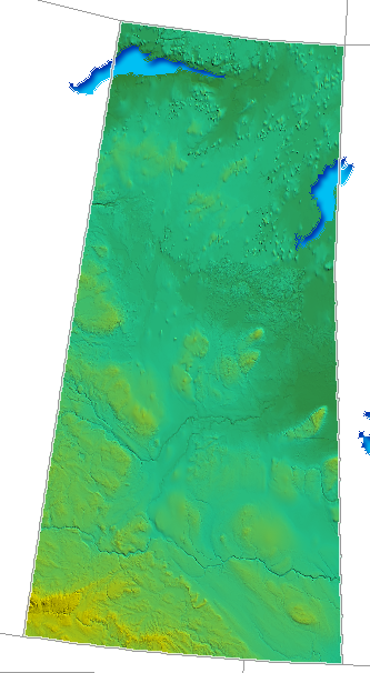
The geography of Saskatchewan is unique among the provinces and territories of Canada in some respects. It is one of only two landlocked regions (Alberta is the other) and it is the only region whose borders are not based on natural features like coasts, lakes, rivers, or drainage divides. The borders of Saskatchewan, which make it very nearly a trapezoid, were determined in 1905 when it became a Canadian province. Saskatchewan has a total area of 651,036 square kilometres (251,366 sq mi) of which 591,670 km2 (228,450 sq mi) is land and 59,366 km2 (22,921 sq mi) is water.
The province's name comes from the Saskatchewan River, whose Cree name is: kisiskatchewani sipi, meaning "swift flowing river".
Saskatchewan can be divided into three regions: grassland (part of the Great Plains) in the south, aspen parkland in the centre, and forest in the north. The forest region lies partly on the northern part of the Great Plains and partly on the Canadian Shield. Its principal rivers are the Assiniboine River, and North and South Saskatchewan Rivers.
Saskatchewan is bordered on the west by Alberta, on the north by the Northwest Territories, on the east by Manitoba, and on the south by the U.S. states of Montana and North Dakota.
Saskatchewan is very close to a trapezoid. Its western border runs concurrent with the 4th meridian or the 110°W longitude, separating Saskatchewan from the province of Alberta. This border extends in length for 1,225 kilometres (761 mi) and was established in 1905 when both provinces were formed.
Saskatchewan's eastern border includes minor measurement errors from the 1880s, so that it does not lie perfectly on the 102°W longitude, but rather it is slightly west of that meridian from 60°N parallel to 55°47'N, then slightly east of that until the Canada–United States border – an irregular line (rather than a straight one) for its 1,225-kilometre (761 mi) distance. When Saskatchewan was formed in 1905, Manitoba and the District of Keewatin were the neighbouring areas to the east. Manitoba was enlarged in 1912 north to the 60th parallel, becoming Saskatchewan's only eastern neighbour. This remaining section of the border was determined by survey between 1961 and 1972.
Saskatchewan's southern border with the United States sits approximately on the 49th parallel, as agreed in the Treaty of 1818—though minor measurement errors during the 1870s International Boundary Survey result in some variance between the actual Canada–United States border and the 49th parallel. This boundary was not formally established until the 1867 survey. This border extends 627 kilometres (390 mi) across southern Saskatchewan.
The Northwest Territories is north of the 60th parallel which forms the northern border of the province. This border extends 445 kilometres (277 mi) across northern Saskatchewan. The aforementioned measurement errors in the 1880s surveys place the Saskatchewan / Manitoba border approximately 400 metres (440 yd) west of the 102nd meridian and the accurately measured Northwest Territories / Nunavut border, just missing a true quadripoint of the Saskatchewan / Manitoba/Northwest Territories / Nunavut borders.
Hub AI
Geography of Saskatchewan AI simulator
(@Geography of Saskatchewan_simulator)
Geography of Saskatchewan
The geography of Saskatchewan is unique among the provinces and territories of Canada in some respects. It is one of only two landlocked regions (Alberta is the other) and it is the only region whose borders are not based on natural features like coasts, lakes, rivers, or drainage divides. The borders of Saskatchewan, which make it very nearly a trapezoid, were determined in 1905 when it became a Canadian province. Saskatchewan has a total area of 651,036 square kilometres (251,366 sq mi) of which 591,670 km2 (228,450 sq mi) is land and 59,366 km2 (22,921 sq mi) is water.
The province's name comes from the Saskatchewan River, whose Cree name is: kisiskatchewani sipi, meaning "swift flowing river".
Saskatchewan can be divided into three regions: grassland (part of the Great Plains) in the south, aspen parkland in the centre, and forest in the north. The forest region lies partly on the northern part of the Great Plains and partly on the Canadian Shield. Its principal rivers are the Assiniboine River, and North and South Saskatchewan Rivers.
Saskatchewan is bordered on the west by Alberta, on the north by the Northwest Territories, on the east by Manitoba, and on the south by the U.S. states of Montana and North Dakota.
Saskatchewan is very close to a trapezoid. Its western border runs concurrent with the 4th meridian or the 110°W longitude, separating Saskatchewan from the province of Alberta. This border extends in length for 1,225 kilometres (761 mi) and was established in 1905 when both provinces were formed.
Saskatchewan's eastern border includes minor measurement errors from the 1880s, so that it does not lie perfectly on the 102°W longitude, but rather it is slightly west of that meridian from 60°N parallel to 55°47'N, then slightly east of that until the Canada–United States border – an irregular line (rather than a straight one) for its 1,225-kilometre (761 mi) distance. When Saskatchewan was formed in 1905, Manitoba and the District of Keewatin were the neighbouring areas to the east. Manitoba was enlarged in 1912 north to the 60th parallel, becoming Saskatchewan's only eastern neighbour. This remaining section of the border was determined by survey between 1961 and 1972.
Saskatchewan's southern border with the United States sits approximately on the 49th parallel, as agreed in the Treaty of 1818—though minor measurement errors during the 1870s International Boundary Survey result in some variance between the actual Canada–United States border and the 49th parallel. This boundary was not formally established until the 1867 survey. This border extends 627 kilometres (390 mi) across southern Saskatchewan.
The Northwest Territories is north of the 60th parallel which forms the northern border of the province. This border extends 445 kilometres (277 mi) across northern Saskatchewan. The aforementioned measurement errors in the 1880s surveys place the Saskatchewan / Manitoba border approximately 400 metres (440 yd) west of the 102nd meridian and the accurately measured Northwest Territories / Nunavut border, just missing a true quadripoint of the Saskatchewan / Manitoba/Northwest Territories / Nunavut borders.
Recent media