
Recent from talks
Great Sandy Strait
Knowledge base stats:
Talk channels stats:
Members stats:
Great Sandy Strait
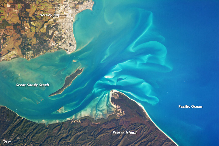
The Great Sandy Strait is a strait in the Australian state of Queensland of 70 kilometres (43 mi) length which separates mainland Queensland from K'gari. It is also an offshore locality in the Fraser Coast Region local government area. To the north of the strait is Hervey Bay. In the 2021 census, Great Sandy Strait had "no people or a very low population".
The Great Sandy Strait extends south from Hervey Bay to Inskip Point. The Mary River enters the strait at River Heads. It covers an area of 932 square kilometres (360 sq mi). The southern entrance to the strait is about 2 kilometres (1.2 mi) wide.
There are numerous named and unnamed islands in the strait. The named island are from north to south: Big Woody Island, Round Island, Little Woody Island, Picnic Island, Duck Island, Walsh Island, Turkey Island, Bookar Island, Thomas Island, Slain Island, Tooth Island, Round Bush Island, New Island, Garden Island, Dream Island, and Stewart Island.
Most of the island are low and sandy in character. Only a few have significant elevations, e.g. Big Woody Island rises to 50 metres (160 ft) above sea level. Although most of the islands are uninhabitable, there is a small area of residential development on the north-west of Stewart Island (25°36′58″S 152°57′13″E / 25.6161°S 152.9536°E).
In July and August 1799 Matthew Flinders chartered the coast from Moreton Bay to Hervey Bay in the Norfolk. Although he established that K'gari was not a peninsula (as was then believed) but an island, he failed to find a navigable channel through the Great Sandy Strait. His explorations of the area is commemorated by a monument called Matthew Flinders Lookout at the top of an escarpment facing the bay in Dayman Park, Urangan (25°17′21″S 152°54′29″E / 25.2893°S 152.9080°E).
Lieutenant Joseph Dayman was the first European to navigate through the Great Sandy Strait on 10 November 1846 in a small decked boat called the Asp. It had been intended that Dayman rendezvous with HMS Rattlesnake but that ship had already departed. Dayman decided it was safer to take the Asp through the Great Sandy Strait rather than risk taking the route to the ocean side of K'gari as he was concerned about rounding the Breaksea Spit.
In the 2016 census, Great Sandy Strait had a population of 4 people.
In the 2021 census, Great Sandy Strait had "no people or a very low population".
Hub AI
Great Sandy Strait AI simulator
(@Great Sandy Strait_simulator)
Great Sandy Strait
The Great Sandy Strait is a strait in the Australian state of Queensland of 70 kilometres (43 mi) length which separates mainland Queensland from K'gari. It is also an offshore locality in the Fraser Coast Region local government area. To the north of the strait is Hervey Bay. In the 2021 census, Great Sandy Strait had "no people or a very low population".
The Great Sandy Strait extends south from Hervey Bay to Inskip Point. The Mary River enters the strait at River Heads. It covers an area of 932 square kilometres (360 sq mi). The southern entrance to the strait is about 2 kilometres (1.2 mi) wide.
There are numerous named and unnamed islands in the strait. The named island are from north to south: Big Woody Island, Round Island, Little Woody Island, Picnic Island, Duck Island, Walsh Island, Turkey Island, Bookar Island, Thomas Island, Slain Island, Tooth Island, Round Bush Island, New Island, Garden Island, Dream Island, and Stewart Island.
Most of the island are low and sandy in character. Only a few have significant elevations, e.g. Big Woody Island rises to 50 metres (160 ft) above sea level. Although most of the islands are uninhabitable, there is a small area of residential development on the north-west of Stewart Island (25°36′58″S 152°57′13″E / 25.6161°S 152.9536°E).
In July and August 1799 Matthew Flinders chartered the coast from Moreton Bay to Hervey Bay in the Norfolk. Although he established that K'gari was not a peninsula (as was then believed) but an island, he failed to find a navigable channel through the Great Sandy Strait. His explorations of the area is commemorated by a monument called Matthew Flinders Lookout at the top of an escarpment facing the bay in Dayman Park, Urangan (25°17′21″S 152°54′29″E / 25.2893°S 152.9080°E).
Lieutenant Joseph Dayman was the first European to navigate through the Great Sandy Strait on 10 November 1846 in a small decked boat called the Asp. It had been intended that Dayman rendezvous with HMS Rattlesnake but that ship had already departed. Dayman decided it was safer to take the Asp through the Great Sandy Strait rather than risk taking the route to the ocean side of K'gari as he was concerned about rounding the Breaksea Spit.
In the 2016 census, Great Sandy Strait had a population of 4 people.
In the 2021 census, Great Sandy Strait had "no people or a very low population".
Recent media