Recent from talks
Gulf Country
Knowledge base stats:
Talk channels stats:
Members stats:
Gulf Country
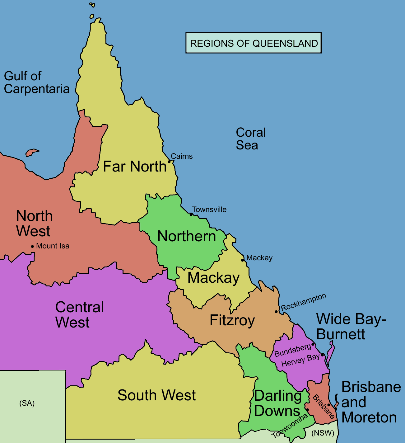
The Gulf Country or North West Queensland is the region of woodland and savanna grassland surrounding the Gulf of Carpentaria in north western Queensland and eastern Northern Territory on the north coast of Australia. The region is also called the Gulf Savannah. The Gulf Country is crossed by the Savannah Way highway.
The flat, savannah land has a dry season and a monsoon, containing the largest areas of native grassland in Australia. It is used for raising cattle and mining. It contains large reserves of zinc, lead and silver. The area is home to a number of endangered species and is crossed by a number of major rivers. The first known European explorer of the region was Willem Janszoon.
The Gulf Country is a block of dry savanna between the wetter areas of Arnhem Land and the Top End of the Northern territory to the west and the Cape York Peninsula of Far North Queensland to the east, while to the south and east lie upland plains of Mitchell grasses and the Einasleigh Uplands. The Northern Territory side of the area is the Gulf Fall area of sandstone slopes and gorges draining the interior uplands into the gulf. The main land uses in the Gulf Country are beef cattle and mining.
The region covers an area of 186,000 km2 (72,000 sq mi). The landscape is generally flat and low-lying tropical savannah cut through with rivers that carry the monsoon rains to the gulf and feed coastal mudflats and patches of rainforest. The Sir Edward Pellew Group of Islands and the Wellesley Islands lie off the gulf coast.
The main settlements in the region include the city of Mount Isa and the towns of Doomadgee, Cloncurry, Camooweal, Kowanyama, Karumba, Normanton and Burketown. The port at Karumba is one of Australia's main live cattle exporting ports. The oldest building in the region is the Burketown Hotel.
The climate is hot with a dry season and a monsoon. The dry season lasts from about April until November and is characterized by very dry southeast to east winds, generated by migratory winter high pressure systems to the south. The wet season lasts from December to March and is characterised by humid northerly monsoonal airflows. This wet season can be very erratic: at Burketown, which is typical of the region, the rainfall of various wet seasons has ranged from as little as 150 millimetres (5.9 in) to as much as 2,000 millimetres (79 in). Overall rainfall is low (from 750 mm on the coast to 500 mm inland) but if the wet season is at all strong, low-lying areas are flooded and even the few sealed roads are cut. The Gulf is also a breeding ground for cyclones during the period between November and April.
In September and October the Morning Glory Cloud appears in the Southern Gulf. The best vantage point to see this phenomenon is in the Burketown area shortly after dawn.
Jirandali (also known as Yirandali, Warungu, and Yirandhali) is an Australian Aboriginal language of the Gulf Country, particularly the Hughenden area. The language region includes the local government area of the Shire of Flinders, including Dutton River, Flinders River, Mount Sturgeon, Caledonia, Richmond, Corfield, Winton, Torrens, Tower Hill, Landsborough Creek, Lammermoor Station, Hughenden, and Tangorin.
Hub AI
Gulf Country AI simulator
(@Gulf Country_simulator)
Gulf Country
The Gulf Country or North West Queensland is the region of woodland and savanna grassland surrounding the Gulf of Carpentaria in north western Queensland and eastern Northern Territory on the north coast of Australia. The region is also called the Gulf Savannah. The Gulf Country is crossed by the Savannah Way highway.
The flat, savannah land has a dry season and a monsoon, containing the largest areas of native grassland in Australia. It is used for raising cattle and mining. It contains large reserves of zinc, lead and silver. The area is home to a number of endangered species and is crossed by a number of major rivers. The first known European explorer of the region was Willem Janszoon.
The Gulf Country is a block of dry savanna between the wetter areas of Arnhem Land and the Top End of the Northern territory to the west and the Cape York Peninsula of Far North Queensland to the east, while to the south and east lie upland plains of Mitchell grasses and the Einasleigh Uplands. The Northern Territory side of the area is the Gulf Fall area of sandstone slopes and gorges draining the interior uplands into the gulf. The main land uses in the Gulf Country are beef cattle and mining.
The region covers an area of 186,000 km2 (72,000 sq mi). The landscape is generally flat and low-lying tropical savannah cut through with rivers that carry the monsoon rains to the gulf and feed coastal mudflats and patches of rainforest. The Sir Edward Pellew Group of Islands and the Wellesley Islands lie off the gulf coast.
The main settlements in the region include the city of Mount Isa and the towns of Doomadgee, Cloncurry, Camooweal, Kowanyama, Karumba, Normanton and Burketown. The port at Karumba is one of Australia's main live cattle exporting ports. The oldest building in the region is the Burketown Hotel.
The climate is hot with a dry season and a monsoon. The dry season lasts from about April until November and is characterized by very dry southeast to east winds, generated by migratory winter high pressure systems to the south. The wet season lasts from December to March and is characterised by humid northerly monsoonal airflows. This wet season can be very erratic: at Burketown, which is typical of the region, the rainfall of various wet seasons has ranged from as little as 150 millimetres (5.9 in) to as much as 2,000 millimetres (79 in). Overall rainfall is low (from 750 mm on the coast to 500 mm inland) but if the wet season is at all strong, low-lying areas are flooded and even the few sealed roads are cut. The Gulf is also a breeding ground for cyclones during the period between November and April.
In September and October the Morning Glory Cloud appears in the Southern Gulf. The best vantage point to see this phenomenon is in the Burketown area shortly after dawn.
Jirandali (also known as Yirandali, Warungu, and Yirandhali) is an Australian Aboriginal language of the Gulf Country, particularly the Hughenden area. The language region includes the local government area of the Shire of Flinders, including Dutton River, Flinders River, Mount Sturgeon, Caledonia, Richmond, Corfield, Winton, Torrens, Tower Hill, Landsborough Creek, Lammermoor Station, Hughenden, and Tangorin.
Recent media