.jpg/250px-Haigerloch_-_Altstadt_-_Ansicht_aus_Süden_vom_Römerturm_(2).jpg "Haigerloch")
.jpg/2000px-Haigerloch_-_Altstadt_-_Ansicht_aus_Süden_vom_Römerturm_(2).jpg)
Community hub
Recent from talks
Contribute something
Nothing was collected or created yet.
Haigerloch
View on WikipediaThis article needs additional citations for verification. (January 2023) |
Haigerloch (German pronunciation: [ˈhaɪɡɐˌlɔx] ⓘ) is a town in the north-western part of the Swabian Alb in Germany.
Key Information
.jpg)


Geography
[edit]Geographical location
[edit]Haigerloch lies at between 430 and 550 metres elevation in the valley of the Eyach river, which forms two loops in a steep shelly limestone valley. The town is therefore also called the 'Felsenstädtchen' (rocky/cliffy small town).
Neighbouring municipalities
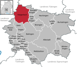
[edit]Haigerloch's neighbouring municipalities are specified below in clockwise order from the north, and belong to the Zollernalbkreis unless indicated.
Starzach ¹, Rangendingen, Grosselfingen, Balingen, Geislingen, Rosenfeld, Sulz am Neckar ², Empfingen ³ and Horb am Neckar ³.
¹ Landkreis Tübingen, ² Landkreis Rottweil, ³ Landkreis Freudenstadt
Districts
[edit]Haigerloch consists of the following nine districts:
- Bad Imnau
- Bittelbronn
- Gruol
- Hart
- Haigerloch
- Owingen
- Stetten
- Trillfingen
- Weildorf
It is located 397 m above mean sea level and has 572 inhabitants (31 December 2011). Bad Imnau was incorporated on 1 August 1973 town Haigerloch.
History
[edit]The city came in 1381 with the reign Haigerloch to the Habsburgs, the fief passed it in the 15th century to the lords of Weitingen. In 1516 Imnau was sold to the Count of Zollern. Imnau had inhabitants:
- 1824 440,
- 1836 591
- 1890 507
Mineral resources
[edit]In 1700, the physician Samuel Caspar discovered small pots source in the valley of the Eyach. 1733 Prince source was exposed, which is named after Prince Joseph Friedrich von Hohenzollern. In 1905, the Apollo-source was taken in by the family Imnau Pope, which was sold to Commerce Carl Haegele in the following year.
History
[edit]The first documented mention of Haigerloch was in the year 1095 on the occasion of the gift of the local castle. This castle was probably located in the area around the Upper Town. By 1200 the Counts of Hohenberg appeared as the local lords and built a new castle on the Schlossberg. The lower town evolved into a market town. Rudolf I, a brother-in-law of Albert II Von Hohenberg-Haigerloch, awarded the town charter to Haigerloch before 1231. In 1268 a battle was fought just outside the city between Zollern and Hohenberg. In 1291 the city was besieged by Count Eberhard I of Württemberg; in 1347 the town was besieged again. From 1356 onward the upper town and lower town were administratively separated but were reunited when the lordship of Haigerloch was sold to Austria in 1381. The Habsburgs pawned the property on several occasions, including to the Counts of Württemberg.
In 1487 rule of the city fell to the Hohenzollern. In 1567 under Christoph von Hohenzollern-Haigerloch the area around Haigerloch was an independent territory within the area of the Holy Roman Empire as Hohenzollern-Haigerloch. In this period, the present castle complex was built on the Schlossberg as the residence of the counts of Hohenzollern-Haigerloch, replacing the former high-medieval structure. In 1634 rule of the city descended to the line of Hohenzollern-Sigmaringen, whose residence city was the city of Haigerloch between 1737 and 1769.
In the last months of World War II, Haigerloch was the location of the Kaiser Wilhelm Institute of Physics, part of the German nuclear programme, which had the goal of achieving practical use of nuclear fission. According to contemporary views, the atomic bomb was not a direct objective of this work, but initially only the construction of the Haigerloch research reactor, which was constructed in a beer cellar beneath the palace church. Through courageous negotiations by the pastor to rescue the reactor facility it was spared from demolition by an American command on April 24, 1945, and today is the site of the Atomkeller-Museum with a replica of the reactor.[3]
Politics
[edit]Local council
[edit]In the local council election of 13 June 2004, the result was:
Culture and objects of interest
[edit]Haigerloch lies on the Ferienstraße (holiday road) and on the Hohenzollernstraße.
Museums
[edit]- Atomkeller-Museum (atomic cellar museum), former research reactor during World War II
- Synagogue Haigerloch,[4] former synagogue
Notable buildings
[edit]- Atomic cellar in the rock under the castle church
- Roman tower Burg Haigerloch (Römerturm)
- Lower part of town church
- Jewisch cemetery (Haigerloch)
- Former synagogue[5]
Partnerships between cities
[edit] Noyal-sur-Vilaine, France
 Sokobanja, Serbia
Economics and infrastructure
[edit]
Roads
[edit]The L410 connects the city with Rangendingen to the east. The L360 forms the feeder, along with the federal highway B463, to the A81 motorway.
Local industry
[edit]One of the few rock salt mines still active in Germany is in the Stetten quarter.[6] Salt has been extracted here since 1854.[7]
Notable people
[edit]
- Salomon Schweigger (1551–1622), evangelic parson and traveller to the Orient
- Christoph, Count of Hohenzollern-Haigerloch (1552–1592), first Count of Hohenzollern-Haigerloch
- Johann Christoph, Count of Hohenzollern-Haigerloch (1586–1620), second Earl of Hohenzollern-Haigerloch
- Charles, Count of Hohenzollern-Haigerloch (1588–1634), third Earl of Hohenzollern-Haigerloch
- Franz Christoph Anton, Count of Hohenzollern-Sigmaringen (1699–1767), Canon, First Minister of the Electorate of Cologne
- Christian Großbayer (1718–1782), architect of the late Baroque
- Simon Anton Zimmermann (1807–1876), conductor, choirmaster and composer
- Father Desiderius Lenz, born Peter Lenz (1832–1928), painter and founder of the Beuron School of Art
- Hermann Eger (1877–1944), born in Weildorf, politician (center), member of the Reichstag
- Karl Widmaier (1886–1931), writer
- Karl Hurm (1930–2019), painter
References
[edit]- ^ Bürgermeisterwahl Haigerloch 2022, Staatsanzeiger.
- ^ "Alle politisch selbständigen Gemeinden mit ausgewählten Merkmalen am 31.12.2023" (in German). Federal Statistical Office of Germany. 28 October 2024. Retrieved 16 November 2024.
- ^ Bethe, Hans A. (July 2000). "The German Uranium Project". Physics Today. 53 (7): 34–36. doi:10.1063/1.1292473.
- ^ "Startseite - Ehemalige Synagoge Haigerloch". www.synagoge-haigerloch.de. Retrieved October 26, 2019.
- ^ "Die Synagoge in Haigerloch (Zollernalbkreis)". www.alemannia-judaica.de.
- ^ miners song Steigerlied
- ^ Mine
- This is a translation of the German wiki page de:Haigerloch
External links
[edit]![]() Media related to Haigerloch at Wikimedia Commons
Media related to Haigerloch at Wikimedia Commons
- Official website (in German)
Towns and municipalities in Zollernalb district | ||
|---|---|---|
 | ||
| International | |
|---|---|
| National | |
| Geographic | |
| Other | |
Haigerloch
View on GrokipediaHaigerloch is a town in the Zollernalbkreis district of Baden-Württemberg, southwestern Germany, situated in the northwestern Swabian Jura along the Eyach River.[1][2] As of 2024, its population is estimated at 10,930 residents across an area of 76.44 square kilometers.[1] The town is characterized by its picturesque old town built into rocky terrain, earning it the nickname "Felsenstädtchen" (Little Rock Town), and features a Renaissance-style castle originating from medieval fortifications first documented in 1095.[2][3] Haigerloch gained international historical notoriety as the location of the Haigerloch research reactor (B-VIII), an experimental nuclear assembly constructed by German physicists in a bunker beneath the castle church in early 1945 as part of the Uranverein project aimed at developing nuclear technology during World War II; the reactor, composed of uranium oxide cubes and heavy water moderator, failed to achieve criticality due to insufficient purity of materials and design flaws.[4][5] The town's medieval core includes half-timbered buildings and a Romanesque tower, reflecting its development under feudal lords and later the Hohenzollern family, who ruled the County of Hohenzollern-Haigerloch from the 16th century.[3] Today, Haigerloch preserves this heritage through sites like the Atomkeller Museum, which documents the wartime nuclear experiments, alongside natural attractions in the Swabian Alb region conducive to hiking and cultural tourism.[6]
Geography
Location and topography
Haigerloch is located in the Zollernalbkreis district of Baden-Württemberg, Germany, on the northwestern edge of the Swabian Alb, a low mountain range characterized by its Jurassic limestone plateaus.[7] The town occupies a position approximately 25 kilometers south of Tübingen and 20 kilometers southeast of Reutlingen, within a landscape shaped by tectonic uplift and erosion that has produced the Alb's distinctive escarpment and valleys.[8] [9] The settlement lies primarily in the Eyach River valley, where the river traces two pronounced loops through a steep, shelly limestone gorge, with elevations ranging from 430 to 550 meters above sea level.[10] This topography creates a confined, meandering floodplain hemmed by higher plateaus, fostering natural isolation and defensibility through the valley's narrow confines and elevated surrounds. Bordered by municipalities including Rangendingen to the north and Bisingen to the south, the area exemplifies the Swabian Alb's karst features, including soluble limestone bedrock that has formed extensive underground cave networks and provided abundant raw materials like limestone for local geology-driven settlement patterns.[11] [12]Administrative divisions
Haigerloch is divided into nine districts, known as Ortsteile: Bad Imnau, Bittelbronn, Gruol, Hart, Haigerloch (the central core), Owingen, Stetten, Trillfingen, and Weildorf.[13][14] The municipality spans 76.45 km², integrating urban settlement in the core with rural areas in the peripheral districts.[15] This structure resulted from Baden-Württemberg's municipal reform in the early 1970s, which amalgamated Haigerloch with eight formerly independent villages to form the enlarged town on January 1, 1972, and subsequent dates.[16][17] As part of the Zollernalbkreis district, Haigerloch's boundaries align with regional administrative zoning, including provisions for historical preservation in the core district's old town and designated areas for industrial use in peripheral zones like Gruol.[18] Certain districts retain semi-autonomous local administration through Ortschaftsverwaltungen, handling community-specific matters such as in Gruol.[19]Natural resources
Haigerloch's geology is dominated by the Jurassic limestone of the Swabian Alb, forming a karst landscape with abundant deposits of white, porous limestone that has historically been quarried on a small scale for local construction and lime. This formation, dating to the Late Jurassic (Oxfordian-Kimmeridgian stages, circa 163-150 million years ago), constitutes the primary mineral resource, supporting the region's plateaus and valleys without significant associated metallic ores.[20] Subsurface evaporites include halite deposits exploited at the Stetten salt mine within Haigerloch municipality, part of broader Permian Zechstein formations yielding industrial salt through solution mining techniques.[21] Surface and groundwater resources derive from the Eyach River—a right tributary of the Neckar spanning 50 km and traversing Haigerloch—augmented by karst aquifers in the limestone, which provide reliable but vulnerable hydrological assets prone to rapid recharge and drainage. The region features no verifiable deposits of heavy metals, fossil fuels, or uranium, reflecting the limestone-centric geology and contributing to historical resource limitations for energy-intensive endeavors.[22]History
Early settlement and medieval period
, bolstering prosperity under Hohenberg oversight until the lordship's sale to Habsburg Austria in 1381. The parish church of St. Ulrich, first attested in 1237, served as the medieval spiritual center for the upper town, underscoring ecclesiastical integration into feudal life.[23][25]Hohenzollern governance and early modern era
In 1634, upon the extinction of the Hohenzollern-Haigerloch line, the lordship of Haigerloch was incorporated into the Principality of Hohenzollern-Sigmaringen, maintaining continuity in dynastic rule while integrating into a larger territorial structure.[23][26] This transition occurred amid the disruptions of the Thirty Years' War, underscoring Haigerloch's role in regional stability despite external conflicts, as the principality emphasized administrative consolidation over expansionist ambitions.[23] Haigerloch's position on a defensible rock spur above the Eyach River, near the Württemberg border, enhanced its strategic value for border defense and oversight of trade routes in the Swabian Alb.[23] The local economy centered on agriculture and forestry, with small-scale trade activities, including textile and livestock dealings by permitted Jewish merchants who paid protection fees and contributed to princely revenues through lending and market participation.[27] Fortifications evolved under earlier Hohenzollern influence, as Count Christoph (r. 1576–1592) rebuilt the medieval castle into a Renaissance palace and initiated the Schlosskirche, prioritizing residency while preserving the site's inherent defensive topography amid post-war recovery efforts.[23] Residence status further bolstered development when Prince Joseph Friedrich von Hohenzollern-Sigmaringen (r. 1737–1769) relocated his court to Haigerloch, commissioning baroque renovations to the Schlosskirche and constructing the St. Anna Church, which stimulated local craftsmanship and economic activity without major industrial shifts.[23] Population expanded gradually under this governance; by circa 1800, the Jewish community numbered 30–36 families, reflecting broader demographic stability in a town reliant on agrarian livelihoods rather than urban growth.[27] The principality's mediatization in 1849 transferred sovereignty to Prussia, ending direct Hohenzollern control but introducing administrative reforms under Prussian oversight, such as enhanced road networks that improved connectivity and economic resilience in the border region.[23] By 1854, Haigerloch served as the seat of a Prussian Oberamt, formalizing local self-governance while aligning with centralized Prussian policies that prioritized infrastructure over feudal fragmentation.[23]Industrialization and 19th-20th century developments
The establishment of the Salzbergwerk Stetten salt mine in 1854, located adjacent to Haigerloch, markedly enhanced local employment opportunities and contributed to economic stabilization in the region.[28] This development aligned with Prussia's efforts to exploit Hohenzollern's mineral resources following the territory's cession from Württemberg in 1849, fostering modest growth in related extractive and processing activities amid the broader shift toward industrial pursuits.[29] Railway infrastructure expanded significantly in the late 19th and early 20th centuries, with the Hohenzollerische Landesbahn connecting Eyach to Haigerloch and onward to Hechingen and Sigmaringen between 1899 and 1912, improving access to markets and supporting trade in local goods.[29] Industrialization in the Hohenzollern portion of the Zollernalbkreis, including Haigerloch, lagged behind adjacent Württemberg areas, emphasizing small-scale manufacturing and mining over heavy industry; the Oberamt Haigerloch recorded 6,541 inhabitants across its villages in 1861, reflecting gradual demographic expansion tied to these infrastructural gains.[30] During the Weimar Republic, the local economy maintained relative stability through persistent craft-based production and resource extraction, buffering against national hyperinflation and depression impacts via regional self-sufficiency.[31] Under the Nazi regime prior to full wartime mobilization, centralized resource policies indirectly bolstered regional infrastructure via state-directed investments in transport and extraction, though Haigerloch saw no distinct early advancements in specialized heavy industry.[29]World War II nuclear research efforts
In response to intensifying Allied bombing campaigns threatening urban research facilities, the Kaiser Wilhelm Institute for Physics, directed by Werner Heisenberg, relocated its Uranmaschine project to rural sites near Hechingen and Haigerloch in southern Germany during late 1944.[32] The final experimental assembly, designated B-VIII, was constructed in a natural cave beneath Haigerloch castle, selected for its concealment and protection from aerial attacks.[33] Construction commenced in February 1945 under the supervision of Heisenberg's colleague Karl Wirtz, incorporating 664 cubes of natural uranium metal, each approximately 5 cm on side and weighing 2.5 kg, suspended by cables within an aluminum vessel filled with heavy water as the moderator.[34] This configuration aimed to demonstrate a sustained neutron chain reaction through moderated fission in uranium-235 impurities.[35] The B-VIII reactor underwent testing in late March 1945, achieving a neutron multiplication factor (k_eff) of approximately 0.5 to 0.7, indicating a partially self-sustaining chain reaction but falling short of full criticality (k_eff ≥ 1).[35] Operations involved incrementally stacking uranium cubes into a lattice immersed in about 3.5 tons of heavy water, with measurements confirming neutron flux increases but insufficient for power production or explosive applications.[36] Despite these results, the experiment highlighted fundamental constraints: limited heavy water availability, stemming from prior Allied commando raids and bombings on Norwegian production facilities, restricted moderator volume and purity.[37] Earlier reliance on heavy water over graphite—due to undetected boron impurities in German graphite causing excessive neutron absorption—further hampered moderator efficiency, though B-VIII avoided graphite entirely. Resource shortages and strategic misallocations compounded technical hurdles; the program's decentralized structure and diversion of uranium to less prioritized efforts, including radar and other military technologies, delayed scaling.[38] German physicists' overestimation of the critical mass required for a bomb—by factors of thousands—shifted focus toward experimental reactors rather than fast-fission weapons, a misjudgment rooted in incomplete diffusion theory applications and lack of isotope enrichment pursuits.[39] Empirical post-war analyses confirm the Haigerloch assembly produced no viable path to a fission bomb, debunking retrospective claims of near-success; its subcritical design yielded neutronics data on moderation and multiplication but underscored the regime's inefficiencies in mobilizing industrial-scale resources under wartime pressures.[40] On April 23, 1945, advancing U.S. forces from the Alsos Mission overran Haigerloch, capturing the cave laboratory, uranium cubes, heavy water barrels, and key scientists including Heisenberg, who had fled but was detained shortly after.[41] The team dismantled and shipped materials stateside for analysis, revealing the German effort's lag: no plutonium production, enrichment, or implosion research had advanced sufficiently for weaponry.[42] This interception prevented potential Soviet acquisition and affirmed Allied intelligence that Nazi nuclear ambitions remained experimental, contributing modestly to reactor science amid broader program failures.[34]Government and administration
Municipal structure
The municipal council (Gemeinderat) of Haigerloch comprises 20 elected members serving five-year terms, with the mayor holding voting rights as a full participant.[43] The most recent election occurred on June 9, 2024, resulting in a council constituted on September 10, 2024.[44] Voter turnout reached 63.9%, with 5,493 of 8,591 eligible voters participating.[45] The mayor, Heiko Lebherz, functions as the chief executive, overseeing administrative operations, policy execution, and representation of the municipality.[46] Appointed deputies assist in these duties, with three Stellvertreter elected in September 2024 to support continuity.[47] The administration employs a three-part departmental structure: the finance office (Kämmerei) for budgeting and fiscal management, the main office (Hauptamt) for general services, and the building office (Bauamt) for infrastructure and planning.[48] Core services encompass waste collection, local education facilities, and historic preservation efforts, funded via annual Haushaltspläne that balance local revenues with state allocations while prioritizing expenditure control.[49][50] The coat of arms features a per pale division of silver (argent) and red (gules), derived from seals dating to the late 13th century under the Counts of Hohenberg, who founded the town around that era. This design persisted through Hohenzollern rule and reflects Haigerloch's medieval origins in the Eyach river valley, evoking regional heritage including early mining activities tied to the area's geological resources.[14][51]Political representation
In the 2024 municipal election for Haigerloch's Gemeinderat, the Freie Wählervereinigung (FWV), a localist group emphasizing pragmatic community governance, secured an absolute majority with 54.9% of the vote and 11 of 18 seats, down from 12 seats in the previous 26-seat council of 2019.[52] The CDU followed with 30.7% and 6 seats, reflecting consistent conservative support amid national trends, while the Sozial-Ökologische Liste (SÖL) obtained 11.1% and 2 seats, and the new Bürger für Haigerloch list gained 3.3% for 1 seat.[52] Voter turnout rose to 64.4% from 59.1% in 2019, indicating stable rural engagement focused on local priorities over partisan national debates.[52]| Party/List | Vote Share (%) | Seats (2024) | Seats (2019) |
|---|---|---|---|
| FWV | 54.9 | 11 | 12 |
| CDU | 30.7 | 6 | N/A* |
| SÖL | 11.1 | 2 | 5 |
| Bürger für Haigerloch | 3.3 | 1 | - |
Economy and infrastructure
Key industries
Haigerloch's economy centers on manufacturing, with a focus on precision engineering, plastics processing, and electronics production, supported by the region's skilled workforce and proximity to Baden-Württemberg's industrial clusters.[56] Prominent firms include Theben AG, a leader in building automation systems like sensors and KNX technology, which reported 130 million euros in revenue and employed approximately 800 people as of 2021.[57] Other notable enterprises encompass AWS Präzisionstechnik GmbH for custom precision components and Hans Volm GmbH for injection-molded plastics, often supplying sectors such as automotive and machinery.[58][59] The Zollernalbkreis, which includes Haigerloch, exhibits an above-average proportion of manufacturing relative to Baden-Württemberg's statewide figures, driven by a dense network of medium-sized enterprises (Mittelstand) rooted in historical craftsmanship and post-war industrial expansion.[60] This structure fosters specialization in high-value, export-oriented goods, with causal ties to the area's engineering heritage and access to regional supply chains, though no active nuclear energy production persists from World War II experiments.[60] Tourism provides supplementary economic activity on a small scale, primarily through visitors to the Atomkeller Museum, which reconstructs the 1945 German nuclear reactor test in a subterranean site beneath Haigerloch Castle, attracting interest in atomic history.[61] Agriculture remains marginal due to the Swabian Alb's hilly topography and fragmented landholdings, serving mainly local food security via small-scale operations rather than large commercial output.[62]Transportation networks
Haigerloch's primary road connection is the Bundesstraße 463 (B463), a federal highway that traverses the town and links it northward to Balingen and southward toward Horb am Neckar, providing access to the A81 motorway via the L360 feeder road near Empfingen. This infrastructure supports efficient regional mobility, with the B463 handling through traffic while local side roads like the L410 connect to adjacent communities such as Rangendingen.[63][64] Rail services center on the Eyach–Hechingen railway line, a single-track, non-electrified route operated by the Hohenzollerische Landesbahn (HzL), which connects Haigerloch station to Eyach and onward to Tübingen Hauptbahnhof in approximately 1 hour and 12 minutes, including a transfer. Local bus networks complement this, with lines such as 310 (to Horb and Hechingen), 320 (to Balingen via Owingen), and 319 (serving intra-town districts like Bittelbronn and Empfingen), ensuring coverage of outlying areas and hourly frequencies on key routes.[65][66] No commercial airport operates within Haigerloch; the closest facility is Stuttgart Airport (STR), situated about 70 kilometers northeast, accessible by car in roughly 45 minutes or via public transport combinations (train to Stuttgart followed by bus or S-Bahn) taking over 2 hours. Post-World War II reconstruction efforts restored the railway and road networks promptly, with the HzL assuming operations in the region by the early 1950s, contributing to sustained connectivity amid broader infrastructural repairs across Baden-Württemberg. Modern operations have experienced few significant disruptions, supported by routine maintenance on the B463 and rail lines.[67][68]Demographics
Population statistics and trends
As of late 2024, Haigerloch had approximately 11,000 residents across its 76.4 km² area, resulting in a population density of roughly 144 inhabitants per square kilometer.[2][69] The population has remained largely stable since the municipal mergers of the 1970s, which incorporated surrounding villages and elevated the total from under 5,000 in the core settlement to over 10,000, reflecting administrative consolidation rather than organic growth.[70] Recent annual changes hover around 0.3%, with minor fluctuations driven by balanced births, deaths, and migration.[1] Historical data for the central settlement indicate slow growth in the 19th and early 20th centuries, from 1,256 residents in 1852 to 1,280 in 1925, coinciding with modest industrialization in the Eyach Valley but punctuated by dips during the World Wars due to combat losses and economic disruption.[71] Post-war recovery stabilized numbers, but the broader municipality experienced a 10% increase from 1990 to 2006 before a slight -1% dip by 2006 (10,823 residents), attributable to net out-migration amid limited local job prospects.[72] Demographic drivers include sub-replacement fertility, averaging 1.31 children per woman from 2001-2006, tied to rural economic constraints that discourage family expansion compared to urban alternatives.[72] An aging profile has intensified, with the proportion aged 60+ projected to rise from 18.4% in 2006 to 21-23% by 2020, exacerbated by negative net migration (-27 persons in 2005-2006) as younger cohorts relocate to nearby cities like Tübingen or Stuttgart for employment, perpetuating low immigration inflows in this peripheral location.[72]Ethnic and social composition
Haigerloch's population is overwhelmingly ethnic German, accounting for 92.8% of residents as of the 2022 census, with 9,597 individuals holding German citizenship out of a total of approximately 10,339. The foreign-born or non-German citizen population comprises 7.2%, or 742 persons, primarily from labor migration tied to post-war industrial needs in the region. Turkish nationals form the largest minority group at 314 individuals (roughly 3% of the total population), followed by Romanians (148) and Poles (58), reflecting patterns of guest worker recruitment from the 1960s onward and more recent EU mobility. Socially, the town exhibits markers of cohesion typical of rural Baden-Württemberg locales, with education emphasizing vocational pathways through local schools and apprenticeships in manufacturing sectors.[73] Crime remains low relative to urban benchmarks; police statistics for the Zollernalb district indicate 265 reported offenses in Haigerloch in 2023, yielding a rate of about 2,400 incidents per 100,000 inhabitants—below the national average of over 5,000—despite a slight uptick attributed to property crimes.[74] This contrasts with higher rates in larger cities, underscoring effective community integration of small migrant groups through employment rather than segregation.[75]Culture and heritage
Museums and educational sites
The Atomkeller Museum, situated in a rock-hewn cellar beneath Haigerloch Castle, preserves the site of Germany's wartime nuclear research facility established in early 1945. It houses a faithful reconstruction of the B-VIII experimental nuclear reactor, assembled by a team led by physicist Werner Heisenberg to test uranium cube arrangements for potential chain reactions using heavy water moderation. Exhibits include replica uranium oxide cubes strung on wires, mimicking the original configuration that achieved only partial criticality due to insufficient materials and geometric inefficiencies.[61][76][77] The museum's displays draw on declassified documents and artifacts to outline the Uranprojekt's evolution from Berlin to Haigerloch amid Allied bombings, underscoring the program's emphasis on fundamental fission studies rather than explosive applications—a distinction rooted in both technical constraints and the researchers' assessments of feasibility. Educational tours and panels utilize primary records to contextualize the experiments' outcomes, refuting postwar exaggerations of imminent German atomic weaponry by highlighting measurable neutron flux limitations and the absence of plutonium production pathways.[78][79] Complementing this, the former synagogue in Haigerloch operates as a modest interpretive site on the town's pre-1933 Jewish community, featuring restored interiors and archival materials on local religious and economic life before deportations in the 1940s. While lacking large-scale science outreach beyond the Atomkeller, Haigerloch's schools incorporate site visits into curricula on regional technical history, fostering awareness of 20th-century physics milestones without broader art or general science centers.[80]Architectural landmarks
Schloss Haigerloch, a medieval castle overlooking the Eyach River, originated around 1200 when the Counts of Hohenberg erected it on a strategic rocky outcrop.[81] The structure later became a residence for the Hohenzollern family, with renovations in 1580 transforming parts into Renaissance style, including the construction of the adjacent castle church.[82] In 1745, Prince Friedrich of Hohenzollern oversaw the conversion of the castle church to Baroque architecture and the erection of the nearby St. Anna Church.[3] The Römerturm, a 12th-century defensive tower on the opposite riverbank, marks the probable site of an earlier fortress first documented in 1095.[23] Haigerloch's Altstadt preserves numerous half-timbered houses from the 16th to 18th centuries, clustered along narrow streets in the Eyach valley bend, reflecting Swabian vernacular building traditions.[83] Subterranean features include the Schlattstetter Caves, natural karst formations adapted during World War II into a reinforced concrete bunker laboratory beneath the castle church, featuring vaulted chambers and ventilation systems for experimental apparatus.[77] Post-1945 Allied bombings damaged parts of the town, prompting reconstruction that maintained the castle and Altstadt's core facades through targeted repairs using original materials where possible.[23]Town partnerships
Haigerloch has maintained a single international town partnership with Noyal-sur-Vilaine, a commune in Brittany, France, since 1972.[84] This Franco-German link, formalized amid post-World War II reconciliation efforts, emphasizes cultural exchange over economic integration, with activities coordinated by the Förderverein Städtefreundschaft Haigerloch-Noyal e.V.[85] The partnership supports youth and educational programs, including reciprocal school visits, such as French students attending events in Haigerloch in 2024, and internships like that of Elise Le Meur from Noyal in the Haigerloch town hall in 2025.[86][87] Sports exchanges, including annual tennis tournaments since the 1970s, and cultural celebrations—marked by a 50th anniversary in 2022 with joint events and publications—have sustained interpersonal ties.[88][89] Empirical outcomes include enhanced language proficiency and cross-cultural awareness for participants, alongside modest tourism from visiting delegations, as evidenced by hosted groups and local media coverage of events.[90] Economic benefits, however, appear negligible, with no documented trade surges or joint ventures; the focus remains on symbolic goodwill and individual mobility rather than material gains, aligning with broader critiques of twinning as supplementary to local self-reliance.[91]Notable individuals
Historical figures
Christoph, the first Count of Hohenzollern-Haigerloch (1552–1592), was born in Haigerloch on March 20, 1552, as the third surviving son of Karl I, Count of Hohenzollern, and inherited the territory in 1576 through partition among the Swabian Hohenzollern brothers.[92] He married Katharina von Welsperg in 1577, securing alliances, and governed during a period of religious tensions following the Reformation, aligning the county with Catholicism while navigating feuds and imperial politics in Swabia.[93] His rule emphasized fortification and local administration, contributing to Haigerloch's emergence as a distinct Hohenzollern enclave amid broader family expansions toward Brandenburg-Prussia. Johann Christoph, his son and successor (1586–1620), was also born and died in Haigerloch, reigning from 1592 and upholding the county's Catholic stance during the early Thirty Years' War prelude, including defensive preparations against Protestant neighbors. The lineage continued through figures like Franz Anton (1657–1702), who managed inheritance disputes and territorial consolidations until the male line's extinction in 1634, after which the county reverted to related Hohenzollern branches.[94] These counts engaged in regional warfare, such as anti-Ottoman coalitions and Swabian League activities, but their impact was confined to feudal governance rather than broader innovation or scholarship. Beyond nobility, pre-20th-century records yield few verifiable non-aristocratic figures of note, such as medieval traders or administrators, reflecting Haigerloch's role as a secondary seat in the Hohenzollern domain rather than a center of trade, learning, or invention. Early Jewish residents existed from the Middle Ages but faced expulsion in 1348 amid Black Death pogroms, with sparse named individuals documented before 16th-century repopulation.[95] This paucity underscores the town's historical subordination to larger Hohenzollern holdings like Hechingen and Sigmaringen.Modern residents
Paul Sebastian Schwenk has served as Chairman of the Board of Theben AG, a Haigerloch-based manufacturer of building automation systems including sensors, timers, and smart energy solutions, since September 2020.[96] Under his leadership, the company expanded into intelligent metering for the energy transition via its subsidiary Theben Smart Energy GmbH, co-managed with Ruwen Konzelmann, and committed to a 30-million-euro facility upgrade in 2025 to enhance production capacity.[97][98] Theben, employing around 430 people, represents a cornerstone of local manufacturing focused on energy-efficient technologies derived from post-war industrial innovation. Helmut Gabeli (1944–2018), a lawyer and former German army officer who resided in Haigerloch from 1968 until his death, contributed significantly to preserving the town's Jewish heritage.[99][100] After relocating for his wife's teaching position, Gabeli researched pre-war Jewish life in Haigerloch, co-founded a local historical association, and facilitated memorials including artifacts from displaced Jewish families and efforts to commemorate Holocaust victims.[101] His work emphasized empirical documentation of the community's history amid the town's wartime associations, supporting ongoing educational initiatives without reliance on unsubstantiated narratives.[102]References
- https://www.wikidata.org/wiki/Q75140