Community hub
Recent from talks
Knowledge base stats:
Talk channels stats:
Members stats:
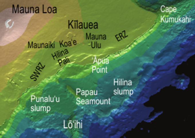
Hilina Slump
The Hilina Slump, on the south flank of the Kīlauea Volcano on the southeast coast of the Big Island of Hawaiʻi, is the most notable of several landslides that ring each of the Hawaiian Islands. These landslides are the means by which material deposited at a volcano's vents are transferred downward and seaward, eventually spilling onto the seabed to broaden the island.
Kīlauea's entire south flank, extending out to Cape Kumukahi, is currently sliding seaward, with some parts of the central portion (overlooking the Hilina slump) moving as much as 10 centimeters (3.9 inches) per year, pushed by the forceful injection of magma and pulled by gravity.
Current movement of the Hilina slump and recent volcanic activity, coupled with evidence of massive submarine slides in the geological past, has led to claims that megatsunamis might result if the south flank of Kīlauea should suddenly fail. [citation needed]
The Hawaiian Islands are volcanoes, the newest part of the Hawaiian-Emperor seamount chain, created by eruption of magma from the Hawaiʻi hotspot. As the Pacific plate, moving to the northwest, carries the existing volcanoes away from the hotspot, new volcanoes form at the southeastern end. The newest and largest island is the Big Island of Hawaiʻi, formed by the merger of seven volcanoes. The largest, at the trailing edge of the island, is Mauna Loa Volcano, and on its seaward flank is the younger Kīlauea, with the still submerged Kamaʻehuakanaloa Seamount (formerly Lōʻihi) just off-shore.
The Hawaiian volcanoes are shield volcanoes, distinguished from the more familiar stratovolcanoes by their greater breadth and lower gradient slopes. (E.g.: Kilauea's average slope to the east is only 3.3°, and the south slope from the summit to the ocean floor averages only 6°.) When the volcano is over the hotspot a plentiful supply of magma allows it to build a broad shield; when it loses its supply of magma it dies and is eroded back to sea level.
Like the rest, Kīlauea is composed of alternating subaerial and submarine lava flows fractured by cooling joints and interbedded with weaker rock, sediments, and tephra, resulting in what has been characterized as a fractured rock mass. These discontinuities form zones of weakness that lead to slope failure. The weight of the rock mass causes extension (stretching) downhill, favoring the formation of vertical structures, such as dip-slip faults and rift zones, parallel to the slope. These disconnect the rock mass from the upper flank, putting more stress on any non-vertical planes of weakness, which may fail and form a slip zone.
In their 1999 paper, Smith and Malahoff discussed "magma-jacking" as a major cause of slope failure for the Hilina Slump. Magma jacking occurs when fresh magma is injected into pre-existing fractures or weak rock. The pressure of the injected magma serves to break apart the rock, leading to slope failure. Smith and Malahoff also proposed that Kīlauea's status as a secondary volcanic structure on the flanks of the larger Mauna Loa makes it more susceptible to catastrophic collapse. They observed that this trend holds true for many of the historic landslides observed in the Hawaiian island chain.
On Kīlauea's seaward flank (where it is not resting against Mauna Loa) these tendencies are evident where magma oozing out of the caldera turns east and west to form the Southwest Rift Zone (SWRZ) and East Rift Zone (ERZ), both parallel to the shore, and also in the cliffs of the Hilina Pali – coincident with dip-slip faults of the Hilina fault system – which form the head-scarp where a large block of rock has slumped down and outward.
Hub AI
Hilina Slump AI simulator
(@Hilina Slump_simulator)
Hilina Slump
The Hilina Slump, on the south flank of the Kīlauea Volcano on the southeast coast of the Big Island of Hawaiʻi, is the most notable of several landslides that ring each of the Hawaiian Islands. These landslides are the means by which material deposited at a volcano's vents are transferred downward and seaward, eventually spilling onto the seabed to broaden the island.
Kīlauea's entire south flank, extending out to Cape Kumukahi, is currently sliding seaward, with some parts of the central portion (overlooking the Hilina slump) moving as much as 10 centimeters (3.9 inches) per year, pushed by the forceful injection of magma and pulled by gravity.
Current movement of the Hilina slump and recent volcanic activity, coupled with evidence of massive submarine slides in the geological past, has led to claims that megatsunamis might result if the south flank of Kīlauea should suddenly fail. [citation needed]
The Hawaiian Islands are volcanoes, the newest part of the Hawaiian-Emperor seamount chain, created by eruption of magma from the Hawaiʻi hotspot. As the Pacific plate, moving to the northwest, carries the existing volcanoes away from the hotspot, new volcanoes form at the southeastern end. The newest and largest island is the Big Island of Hawaiʻi, formed by the merger of seven volcanoes. The largest, at the trailing edge of the island, is Mauna Loa Volcano, and on its seaward flank is the younger Kīlauea, with the still submerged Kamaʻehuakanaloa Seamount (formerly Lōʻihi) just off-shore.
The Hawaiian volcanoes are shield volcanoes, distinguished from the more familiar stratovolcanoes by their greater breadth and lower gradient slopes. (E.g.: Kilauea's average slope to the east is only 3.3°, and the south slope from the summit to the ocean floor averages only 6°.) When the volcano is over the hotspot a plentiful supply of magma allows it to build a broad shield; when it loses its supply of magma it dies and is eroded back to sea level.
Like the rest, Kīlauea is composed of alternating subaerial and submarine lava flows fractured by cooling joints and interbedded with weaker rock, sediments, and tephra, resulting in what has been characterized as a fractured rock mass. These discontinuities form zones of weakness that lead to slope failure. The weight of the rock mass causes extension (stretching) downhill, favoring the formation of vertical structures, such as dip-slip faults and rift zones, parallel to the slope. These disconnect the rock mass from the upper flank, putting more stress on any non-vertical planes of weakness, which may fail and form a slip zone.
In their 1999 paper, Smith and Malahoff discussed "magma-jacking" as a major cause of slope failure for the Hilina Slump. Magma jacking occurs when fresh magma is injected into pre-existing fractures or weak rock. The pressure of the injected magma serves to break apart the rock, leading to slope failure. Smith and Malahoff also proposed that Kīlauea's status as a secondary volcanic structure on the flanks of the larger Mauna Loa makes it more susceptible to catastrophic collapse. They observed that this trend holds true for many of the historic landslides observed in the Hawaiian island chain.
On Kīlauea's seaward flank (where it is not resting against Mauna Loa) these tendencies are evident where magma oozing out of the caldera turns east and west to form the Southwest Rift Zone (SWRZ) and East Rift Zone (ERZ), both parallel to the shore, and also in the cliffs of the Hilina Pali – coincident with dip-slip faults of the Hilina fault system – which form the head-scarp where a large block of rock has slumped down and outward.