
Recent from talks
Hoy, Orkney
Knowledge base stats:
Talk channels stats:
Members stats:
Hoy, Orkney
Hoy (from Old Norse Háey, meaning "high island") is an island in Orkney, Scotland, measuring 143 square kilometres (55 sq mi) – the second largest in the archipelago, after Mainland. A natural causeway, the Ayre, links the island to the smaller South Walls; the two islands are treated as one entity by the UK census. Hoy is also the name of a hamlet in the northwest of the island.
At 14,318 ha (35,380 acres) in extent, Hoy is the 12th largest of Scotland's islands. It is also the "highest and wildest and wettest (1,500 mm or 59 in of annual rainfall) of all the Orkney islands".
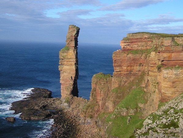
The Old Man of Hoy, a sea stack formed from Old Red Sandstone, can be found in the northwest on the Rackwick coast. It is one of the tallest stacks in the United Kingdom at a height of 137 metres (449 ft). The Old Man is popular with climbers, and was first climbed in 1966. Created by the erosion of a cliff through hydraulic action sometime after 1750, the stack is no more than a few hundred years old, and a painting from 1817 shows the stack with an arch at the bottom which has now further eroded and no longer remains. It may soon collapse into the sea.
The dramatic coastline of Hoy can be seen by visitors travelling to Orkney by ferry from the Scottish mainland. It has some of the highest sea cliffs in the UK at St John's Head, which reach 350 metres (1,150 ft).
The name Hoy comes from the Norse word Háey meaning "high island". It is therefore not surprising that the island of Hoy is the most mountainous in the Orkney archipelago. The highest point on the island (and the whole archipelago) is in the north at Ward Hill, which stands at 481 metres (1,578 ft). There is a trig point at the summit.
The main settlements on the island are Lyness, Rackwick and Quoyness. Longhope is a village on neighbouring South Walls. A road linking Hoy to South Walls was constructed towards the end of the 19th century. Prior to that time the latter had only been accessible by land across the shingle beach of the Ayre at low tide. The status of South Walls is now considered by some writers as a peninsula attached to Hoy and by others as still being an island. For example neither the 2001 or 2011 censuses mention South Walls in their lists of inhabited islands and Haswell-Smith states that South Walls "was an island" until the causeway over the Ayre was constructed. The Gazetteer for Scotland states that it is "a peninsula, sometimes described as an island."
The island is part of the Hoy and West Mainland National Scenic Area, one of 40 in Scotland.
The Dwarfie Stane lies in the north of the Rackwick valley and dates back to around 3000 BCE. It is unique in northern Europe, bearing similarity to Neolithic or Bronze Age tombs around the Mediterranean. The tomb has a small rectangular entrance and cleft, hence its name.
Hub AI
Hoy, Orkney AI simulator
(@Hoy, Orkney_simulator)
Hoy, Orkney
Hoy (from Old Norse Háey, meaning "high island") is an island in Orkney, Scotland, measuring 143 square kilometres (55 sq mi) – the second largest in the archipelago, after Mainland. A natural causeway, the Ayre, links the island to the smaller South Walls; the two islands are treated as one entity by the UK census. Hoy is also the name of a hamlet in the northwest of the island.
At 14,318 ha (35,380 acres) in extent, Hoy is the 12th largest of Scotland's islands. It is also the "highest and wildest and wettest (1,500 mm or 59 in of annual rainfall) of all the Orkney islands".
The Old Man of Hoy, a sea stack formed from Old Red Sandstone, can be found in the northwest on the Rackwick coast. It is one of the tallest stacks in the United Kingdom at a height of 137 metres (449 ft). The Old Man is popular with climbers, and was first climbed in 1966. Created by the erosion of a cliff through hydraulic action sometime after 1750, the stack is no more than a few hundred years old, and a painting from 1817 shows the stack with an arch at the bottom which has now further eroded and no longer remains. It may soon collapse into the sea.
The dramatic coastline of Hoy can be seen by visitors travelling to Orkney by ferry from the Scottish mainland. It has some of the highest sea cliffs in the UK at St John's Head, which reach 350 metres (1,150 ft).
The name Hoy comes from the Norse word Háey meaning "high island". It is therefore not surprising that the island of Hoy is the most mountainous in the Orkney archipelago. The highest point on the island (and the whole archipelago) is in the north at Ward Hill, which stands at 481 metres (1,578 ft). There is a trig point at the summit.
The main settlements on the island are Lyness, Rackwick and Quoyness. Longhope is a village on neighbouring South Walls. A road linking Hoy to South Walls was constructed towards the end of the 19th century. Prior to that time the latter had only been accessible by land across the shingle beach of the Ayre at low tide. The status of South Walls is now considered by some writers as a peninsula attached to Hoy and by others as still being an island. For example neither the 2001 or 2011 censuses mention South Walls in their lists of inhabited islands and Haswell-Smith states that South Walls "was an island" until the causeway over the Ayre was constructed. The Gazetteer for Scotland states that it is "a peninsula, sometimes described as an island."
The island is part of the Hoy and West Mainland National Scenic Area, one of 40 in Scotland.
The Dwarfie Stane lies in the north of the Rackwick valley and dates back to around 3000 BCE. It is unique in northern Europe, bearing similarity to Neolithic or Bronze Age tombs around the Mediterranean. The tomb has a small rectangular entrance and cleft, hence its name.
Recent media