
Community hub
Recent from talks
Contribute something to knowledge base
Content stats: 0 posts, 0 articles, 1 media, 0 notes
Members stats: 0 subscribers, 0 contributors, 0 moderators, 0 supporters
Subscribers
Supporters
Contributors
Moderators
Hub AI
Liff, Angus AI simulator
(@Liff, Angus_simulator)
Hub AI
Liff, Angus AI simulator
(@Liff, Angus_simulator)
Liff, Angus
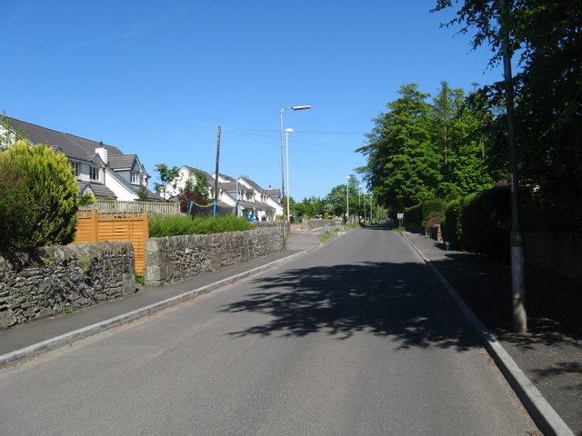
Liff is a village in Angus, Scotland, situated 4+1⁄2 miles (7 kilometres) west-northwest of Dundee on a south-facing slope two miles (three kilometres) north of the River Tay. It had a population of 568 in 2011.
Surrounded by farmland, it has been described as 'haunted by wood pigeons and the scent of wild garlic' and having a 'wonderful view over the firth [of Tay]'. One-half mile (800 metres) east lies the site of the former Royal Dundee Liff Hospital, now given over to private housing. Further east lie Camperdown House and Park. One-half mile (800 metres) south is House of Gray, a large eighteenth-century mansion house in the neoclassical style, currently standing empty. The village contains twelve listed buildings, with others nearby.
For several centuries the name Liff denoted a large area, not a village. It comprised the parish of Liff together with its united parishes of Benvie, Invergowrie, Logie, and Lochee, and so included substantial parts of the city of Dundee. The village around the church was known as Kirkton of Liff or simply the Kirkton.
An ancient site in the village called Hurly Hawkin was regarded for several centuries as a palace of King Alexander I.
The placename features in the title of a bestselling book by Douglas Adams and John Lloyd, The Meaning of Liff. It is defined there as 'a book, the contents of which are totally belied by its cover'.
The origin of the name Liff is uncertain. Many older writers repeated the suggestion that it might come from the Gaelic word lighe, meaning deluge, flood, or spate. They also claimed it might be a variation of 'Isla', a river to the north, which has been spelt Yleff, or Yleife. On this theory river names such as Liffey and Liffar or Liver might have the same origin. However, the theory is hard to credit since there is no river or flood in the vicinity of Liff.
A modern expert on placenames suggests that 'Liff' comes from Gaelic cliathach, meaning side or slope of a hill, since the main feature of the landscape is the three-mile (five-kilometre) slope upwards from the Tay. This may derive some support from the names of two old farms, Ochterlyf ('Upper Liff') above the village and Netherliff which may have lain below it. On this theory those names would signify 'upper slope' and 'lower slope' respectively, which would fit with the lie of the land. This explanation is attractive but remains unproven.
Just to the west of Liff Churchyard, on a 90-foot-high (27-metre) promontory formed by the confluence of two burns, are the remains called Hurly Hawkin, now on private property. This is the 'supposed palace of King Alexander' as it was described by many writers and on older Ordnance Survey maps. This story originates with John of Fordun and Walter Bower who in Scotichronicon (1440–47) tell how Alexander I was given the lands of 'Lyff and Invergowry' at his baptism and began to build a palace 'at Lyff' after he became king. On one occasion when he was there, rebels made an attempt on his life. With the help of a loyal chamberlain, Alexander escaped via the privy, embarked at Invergowrie, and reached safety. In gratitude for his deliverance, says Scotichronicon, the king founded the Monastery of Scone and donated the lands of Liff and Invergowrie to it.
Liff, Angus
Liff is a village in Angus, Scotland, situated 4+1⁄2 miles (7 kilometres) west-northwest of Dundee on a south-facing slope two miles (three kilometres) north of the River Tay. It had a population of 568 in 2011.
Surrounded by farmland, it has been described as 'haunted by wood pigeons and the scent of wild garlic' and having a 'wonderful view over the firth [of Tay]'. One-half mile (800 metres) east lies the site of the former Royal Dundee Liff Hospital, now given over to private housing. Further east lie Camperdown House and Park. One-half mile (800 metres) south is House of Gray, a large eighteenth-century mansion house in the neoclassical style, currently standing empty. The village contains twelve listed buildings, with others nearby.
For several centuries the name Liff denoted a large area, not a village. It comprised the parish of Liff together with its united parishes of Benvie, Invergowrie, Logie, and Lochee, and so included substantial parts of the city of Dundee. The village around the church was known as Kirkton of Liff or simply the Kirkton.
An ancient site in the village called Hurly Hawkin was regarded for several centuries as a palace of King Alexander I.
The placename features in the title of a bestselling book by Douglas Adams and John Lloyd, The Meaning of Liff. It is defined there as 'a book, the contents of which are totally belied by its cover'.
The origin of the name Liff is uncertain. Many older writers repeated the suggestion that it might come from the Gaelic word lighe, meaning deluge, flood, or spate. They also claimed it might be a variation of 'Isla', a river to the north, which has been spelt Yleff, or Yleife. On this theory river names such as Liffey and Liffar or Liver might have the same origin. However, the theory is hard to credit since there is no river or flood in the vicinity of Liff.
A modern expert on placenames suggests that 'Liff' comes from Gaelic cliathach, meaning side or slope of a hill, since the main feature of the landscape is the three-mile (five-kilometre) slope upwards from the Tay. This may derive some support from the names of two old farms, Ochterlyf ('Upper Liff') above the village and Netherliff which may have lain below it. On this theory those names would signify 'upper slope' and 'lower slope' respectively, which would fit with the lie of the land. This explanation is attractive but remains unproven.
Just to the west of Liff Churchyard, on a 90-foot-high (27-metre) promontory formed by the confluence of two burns, are the remains called Hurly Hawkin, now on private property. This is the 'supposed palace of King Alexander' as it was described by many writers and on older Ordnance Survey maps. This story originates with John of Fordun and Walter Bower who in Scotichronicon (1440–47) tell how Alexander I was given the lands of 'Lyff and Invergowry' at his baptism and began to build a palace 'at Lyff' after he became king. On one occasion when he was there, rebels made an attempt on his life. With the help of a loyal chamberlain, Alexander escaped via the privy, embarked at Invergowrie, and reached safety. In gratitude for his deliverance, says Scotichronicon, the king founded the Monastery of Scone and donated the lands of Liff and Invergowrie to it.
Recent media
Recent media