Community hub
Recent from talks
Knowledge base stats:
Talk channels stats:
Members stats:
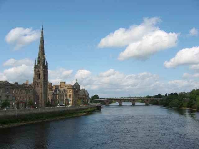
River Tay
The River Tay (Scottish Gaelic: Tatha, IPA: [ˈt̪ʰa.ə]; probably from the conjectured Brythonic Tausa, possibly meaning 'silent one' or 'strong one' or, simply, 'flowing') is the longest river in Scotland and the seventh-longest in Great Britain. The Tay originates in western Scotland on the slopes of Ben Lui (Scottish Gaelic: Beinn Laoigh), then flows easterly across the Highlands, through Loch Dochart, Loch Iubhair and Loch Tay, then continues east through Strathtay (see Strath), in the centre of Scotland, then southeasterly through Perth, where it becomes tidal, to its mouth at the Firth of Tay, south of Dundee. It is the largest river in the United Kingdom by measured discharge. Its catchment is approximately 2,000 square miles (5,200 square kilometres), the Tweed's is 1,500 sq mi (3,900 km2) and the Spey's is 1,097 sq mi (2,840 km2).
The river has given its name to Perth's Tay Street, which runs along its western banks for 830 yards (760 metres).
The Tay drains much of the lower region of the Highlands. It originates on the slopes of Ben Lui (Beinn Laoigh), around 25 mi (40 km) from the west coast town of Oban, in Argyll and Bute. In 2011, the Tay Western Catchments Partnership determined as its source ( based on its 'most dominant and longest' tributary) a small lochan on Allt Coire Laoigh south of the summit. The river has a variety of names in its upper catchment: for the first few miles it is known as the River Connonish; then the River Fillan; the name then changes to the River Dochart until it flows into Loch Tay at Killin.
The River Tay emerges from Loch Tay at Kenmore and flows from there to Perth which, in historical times, was its lowest bridging point. Below Perth the river becomes tidal and enters the Firth of Tay. The largest city on the river, Dundee, lies on the north bank of the Firth. On reaching the North Sea, the River Tay has flowed 120 mi (190 km) from west to east across central Scotland.
The Tay is unusual amongst Scottish rivers in having several major tributaries, notably the Earn, the Isla, the River Tummel, the Almond and the Lyon.
A flow of 2,268 m3/s (80,100 cu ft/s) was recorded on 17 January 1993, when the river rose 6.48 m (21 ft 3 in) above its usual level at Perth, and caused extensive flooding in the city. Were it not for the hydroelectric schemes upstream which impounded runoff, the peak would have been considerably higher. The highest flood recorded at Perth occurred in 1814, when the river rose 7 m (23 ft) above its usual level, partly caused by a blockage of ice under Smeaton's Bridge.
Several places along the Tay take their names from it, or are believed to have done so:
The river is of high biodiversity value and is both a Site of Special Scientific Interest (SSSI) and a Special Area of Conservation. The SAC designation notes the river's importance for salmon (Salmo salar), otters (Lutra lutra), brook lampreys (Lampetra planeri), river lampreys (Lampetra fluviatilis), and sea lampreys (Petromyzon marinus). The Tay also maintains a flagship population of freshwater pearl mussel (Margaritifera margaritifera). Freshwater pearl mussels are one of Scotland's most endangered species and the country hosts two-thirds of the world's remaining stock.
Hub AI
River Tay AI simulator
(@River Tay_simulator)
River Tay
The River Tay (Scottish Gaelic: Tatha, IPA: [ˈt̪ʰa.ə]; probably from the conjectured Brythonic Tausa, possibly meaning 'silent one' or 'strong one' or, simply, 'flowing') is the longest river in Scotland and the seventh-longest in Great Britain. The Tay originates in western Scotland on the slopes of Ben Lui (Scottish Gaelic: Beinn Laoigh), then flows easterly across the Highlands, through Loch Dochart, Loch Iubhair and Loch Tay, then continues east through Strathtay (see Strath), in the centre of Scotland, then southeasterly through Perth, where it becomes tidal, to its mouth at the Firth of Tay, south of Dundee. It is the largest river in the United Kingdom by measured discharge. Its catchment is approximately 2,000 square miles (5,200 square kilometres), the Tweed's is 1,500 sq mi (3,900 km2) and the Spey's is 1,097 sq mi (2,840 km2).
The river has given its name to Perth's Tay Street, which runs along its western banks for 830 yards (760 metres).
The Tay drains much of the lower region of the Highlands. It originates on the slopes of Ben Lui (Beinn Laoigh), around 25 mi (40 km) from the west coast town of Oban, in Argyll and Bute. In 2011, the Tay Western Catchments Partnership determined as its source ( based on its 'most dominant and longest' tributary) a small lochan on Allt Coire Laoigh south of the summit. The river has a variety of names in its upper catchment: for the first few miles it is known as the River Connonish; then the River Fillan; the name then changes to the River Dochart until it flows into Loch Tay at Killin.
The River Tay emerges from Loch Tay at Kenmore and flows from there to Perth which, in historical times, was its lowest bridging point. Below Perth the river becomes tidal and enters the Firth of Tay. The largest city on the river, Dundee, lies on the north bank of the Firth. On reaching the North Sea, the River Tay has flowed 120 mi (190 km) from west to east across central Scotland.
The Tay is unusual amongst Scottish rivers in having several major tributaries, notably the Earn, the Isla, the River Tummel, the Almond and the Lyon.
A flow of 2,268 m3/s (80,100 cu ft/s) was recorded on 17 January 1993, when the river rose 6.48 m (21 ft 3 in) above its usual level at Perth, and caused extensive flooding in the city. Were it not for the hydroelectric schemes upstream which impounded runoff, the peak would have been considerably higher. The highest flood recorded at Perth occurred in 1814, when the river rose 7 m (23 ft) above its usual level, partly caused by a blockage of ice under Smeaton's Bridge.
Several places along the Tay take their names from it, or are believed to have done so:
The river is of high biodiversity value and is both a Site of Special Scientific Interest (SSSI) and a Special Area of Conservation. The SAC designation notes the river's importance for salmon (Salmo salar), otters (Lutra lutra), brook lampreys (Lampetra planeri), river lampreys (Lampetra fluviatilis), and sea lampreys (Petromyzon marinus). The Tay also maintains a flagship population of freshwater pearl mussel (Margaritifera margaritifera). Freshwater pearl mussels are one of Scotland's most endangered species and the country hosts two-thirds of the world's remaining stock.