
Recent from talks
Ifrane
Knowledge base stats:
Talk channels stats:
Members stats:
Ifrane
Ifrane (Arabic: إفران) is a city in the Middle Atlas region of northern Morocco (population 13٫964 as of September 2024). The capital of Ifrane Province in the region of Fès-Meknès, Ifrane is located at an elevation of 1,665 m (5,463 ft). In the regional Tamazight language, "ifran" means caves.
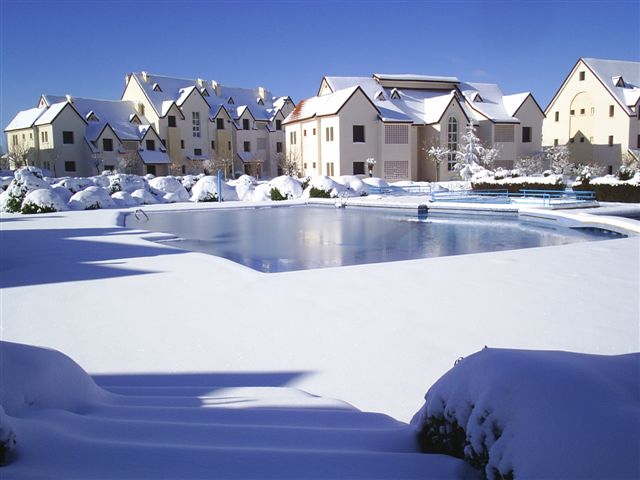
The modern town of Ifrane was established by the French administration in 1928 during the protectorate era for their administration due to its Alpine climate. Ifrane was conceived as a "hill station" or colonial type of settlement. It is a resort town set high up in the mountains so that Europeans could find relief from the summer heat of the interior plains of Morocco. Ifrane, the house of Lake Dayet Iffer is also a popular altitude training destination.
The first permanent settlement of the area dates to the 16th century, when the Sharif Sîdî 'Abd al-Salâm established his community in the Tizguit Valley, seven km downstream from the present town. Ifrane is a colonial "hill station", and a "garden city". It is also an "imperial city", a mountain resort, a provincial administrative center, and a college town.
The first permanent settlement of the area dates to the 16th century, when a sharîf by the name of Sîdî ‘Abd al-Salâm established his community in the Tizguit Valley, seven km downstream from the present town. In the Local Amazigh language, Ifran means "caves". Sîdî ‘Abd al-Salâm’s village, called Zaouiat Sidi Abdeslam (or simply the zâwiyah), consisted at first of cave dwellings hollowed out of the limestone valley wall. Only in the last fifty years or so have its inhabitants built houses aboveground. The caves which now lie under these houses are still used as mangers for animals and for storage.
By the mid-17th century Sîdî ‘Abd al-Salâm’s zâwiyah was well enough established to receive an extensive iqtâ’, or land grant, from the ‘Alâwî sultan Mûlây Rashîd b. Muhammad. The iqtâ’ extended from upstream of present Ifrane down the Tizguit valley all the way to El Hajeb escarpment. Late in the 19th century agro-pastoral groups of the Amazigh Senhadja Beni M’guild and Zenata the Ait Seghrouchen, crossing the Middle Atlas from the upper Moulouya Plain, started grazing their herds of sheep and goats on the surrounding plateau. The livelihood of the zâwiyah was based on irrigated agriculture on the valley floor, livestock grazing and forest resources.
The agricultural plots were held as private property (mulk) but the grazing land was under collective tribal jurisdiction (j’maa). The tribally organized populations of the Ifrane-Azrou area submitted to colonial rule after a period of resistance (1913–1917). Resistance continued higher in the mountains (Timahdit, Jebel Fazzaz) until 1922.
The modern town of Ifrane was established by the French administration in 1929 on land expropriated from the inhabitants of the zâwiya. The town was to be a "hill station", a cool place for colonial families to spend the hot summer months, and it was initially planned according to the "garden city" model of urban design then in vogue. The plan called for chalet-type summer homes in the Alpine style, laid out among gardens and curving tree-lined streets. A royal palace was also built for Sultan Muhammad V. The town's first public buildings consisted of a post office and a church. Moreover, a penitentiary was built which served as a POW camp during World War II.
As elsewhere in Morocco, a shanty town called Timdiqîn soon grew up next to the colonial establishment. It housed the Moroccan population (maids, gardeners, etc.) that serviced the French vacationers. Timdiqîn was separated from the colonial garden city by a deep ravine. After independence, the French properties in the original garden city were slowly bought up by Moroccans. The town was enlarged and endowed with a mosque, a municipal market and public housing estates. Furthermore, the shanty neighborhood of Timdiqîn was rebuilt with proper civic amenities.
Hub AI
Ifrane AI simulator
(@Ifrane_simulator)
Ifrane
Ifrane (Arabic: إفران) is a city in the Middle Atlas region of northern Morocco (population 13٫964 as of September 2024). The capital of Ifrane Province in the region of Fès-Meknès, Ifrane is located at an elevation of 1,665 m (5,463 ft). In the regional Tamazight language, "ifran" means caves.
The modern town of Ifrane was established by the French administration in 1928 during the protectorate era for their administration due to its Alpine climate. Ifrane was conceived as a "hill station" or colonial type of settlement. It is a resort town set high up in the mountains so that Europeans could find relief from the summer heat of the interior plains of Morocco. Ifrane, the house of Lake Dayet Iffer is also a popular altitude training destination.
The first permanent settlement of the area dates to the 16th century, when the Sharif Sîdî 'Abd al-Salâm established his community in the Tizguit Valley, seven km downstream from the present town. Ifrane is a colonial "hill station", and a "garden city". It is also an "imperial city", a mountain resort, a provincial administrative center, and a college town.
The first permanent settlement of the area dates to the 16th century, when a sharîf by the name of Sîdî ‘Abd al-Salâm established his community in the Tizguit Valley, seven km downstream from the present town. In the Local Amazigh language, Ifran means "caves". Sîdî ‘Abd al-Salâm’s village, called Zaouiat Sidi Abdeslam (or simply the zâwiyah), consisted at first of cave dwellings hollowed out of the limestone valley wall. Only in the last fifty years or so have its inhabitants built houses aboveground. The caves which now lie under these houses are still used as mangers for animals and for storage.
By the mid-17th century Sîdî ‘Abd al-Salâm’s zâwiyah was well enough established to receive an extensive iqtâ’, or land grant, from the ‘Alâwî sultan Mûlây Rashîd b. Muhammad. The iqtâ’ extended from upstream of present Ifrane down the Tizguit valley all the way to El Hajeb escarpment. Late in the 19th century agro-pastoral groups of the Amazigh Senhadja Beni M’guild and Zenata the Ait Seghrouchen, crossing the Middle Atlas from the upper Moulouya Plain, started grazing their herds of sheep and goats on the surrounding plateau. The livelihood of the zâwiyah was based on irrigated agriculture on the valley floor, livestock grazing and forest resources.
The agricultural plots were held as private property (mulk) but the grazing land was under collective tribal jurisdiction (j’maa). The tribally organized populations of the Ifrane-Azrou area submitted to colonial rule after a period of resistance (1913–1917). Resistance continued higher in the mountains (Timahdit, Jebel Fazzaz) until 1922.
The modern town of Ifrane was established by the French administration in 1929 on land expropriated from the inhabitants of the zâwiya. The town was to be a "hill station", a cool place for colonial families to spend the hot summer months, and it was initially planned according to the "garden city" model of urban design then in vogue. The plan called for chalet-type summer homes in the Alpine style, laid out among gardens and curving tree-lined streets. A royal palace was also built for Sultan Muhammad V. The town's first public buildings consisted of a post office and a church. Moreover, a penitentiary was built which served as a POW camp during World War II.
As elsewhere in Morocco, a shanty town called Timdiqîn soon grew up next to the colonial establishment. It housed the Moroccan population (maids, gardeners, etc.) that serviced the French vacationers. Timdiqîn was separated from the colonial garden city by a deep ravine. After independence, the French properties in the original garden city were slowly bought up by Moroccans. The town was enlarged and endowed with a mosque, a municipal market and public housing estates. Furthermore, the shanty neighborhood of Timdiqîn was rebuilt with proper civic amenities.
Recent media