
Recent from talks
Intermontane Plateaus
Knowledge base stats:
Talk channels stats:
Members stats:
Intermontane Plateaus
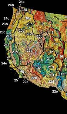
In the context of physical geography, the Intermontane Plateaus is one of eight physiographic regions of the contiguous United States. The region consists mostly of plateaus and mountain ranges lying between the Rocky Mountains on the east and the Cascade and Sierra Nevada Mountains on the west. It is subdivided into three physiographic provinces: the Columbia Plateau in the north, the Basin and Range Province in the central and southwestern portions, and the Colorado Plateau in the southeast. In turn, each of these provinces are each subdivided into a number of physiographic sections.
The Columbia Plateau Province is a large igneous province of flood basalts erupted in Miocene and early Pliocence epochs across the states of Washington, Oregon, Idaho, Nevada, and California.
The province was uplifted and divided into great blocks by faults or monoclinal flexures which were exposed to long-lasting denudation in a mid-Tertiary cycle of erosion. They were then broadly elevated again with renewed movement on some of the faults. The current erosion cycle started in the late Tertiary, when the deep canyons of the region were trenched. The results of the first cycle of erosion are seen in the widespread exposure of the resistant Carboniferous limestone as a broad platform in the southwestern area of greater uplift through central Arizona where the less resistant overlying formations have been eroded away. They are also seen in the development of a series of cuestas: huge, south-facing, retreating escarpments of irregular outline on the edges of the higher formations farther north. Each escarpment stands forth where a resistant formation overlies a weaker, less resistant one. Each escarpment is separated from the next higher one by a broad step of weaker strata.
A series of these geologic formations occurs in southern Utah, where in passing northward from the Carboniferous platform one ascends in succession the Chocolate Cliffs (Triassic sandstones), Vermilion and White Cliffs (Jurassic sandstones), the Gray Cliffs (Cretaceous sandstones, of remarkably cross-bedded structure, interpreted as the dunes of an ancient desert), and finally the Pink Cliffs (Eocene strata of fluviatile and lacustrine origin) of the high, forested plateaus. Associated with these irregular escarpments are occasional rectilinear ridges, the work of extensive erosion on monoclinal structures. A good example of this is Echo Cliffs lying east of the Painted Desert. The Mogollon Rim escarpment is part of the transition zone between the Mogollon Plateau of the Colorado Plateau Province and the Sonoran Desert of the Basin and Range Province.
With the renewal of uplift by which the earlier cycle of erosion was interrupted and the present cycle introduced, inequalities of surface due to renewed faulting were again introduced. These still appear as cliffs, of more nearly rectilinear front than the retreating escarpments formed in the previous cycle. These cliffs are peculiar in gradually passing from one formation to another, and in having a height dependent on the displacement of the fault rather than on the structures in the fault face. They are already somewhat battered and dissected by erosion. The most important line of cliffs of this class is associated with the western and southern boundary of the Plateau Province where it was uplifted from the lower ground. The few rivers of the region must have reached the quiescence of old age in the earlier cycle, but were revived by uplift to a vigorous youth in the current cycle. It is to this newly introduced cycle of physiographic evolution that the deep canyons of the Plateau province are due. Thus the Virgin River, a northern tributary of the Colorado River, has cut a vertical slit, 1000 ft. deep, hardly wider at the top than at the bottom, in the heavy Triassic sandstones of southern Utah. However the most famous example is the Grand Canyon of Arizona, eroded by the Colorado river across the uplifted platform of Carboniferous limestone.
During the current cycle of erosion, several of the faults, whose scarps had been worn away in the previous cycle, have been brought to light again as topographic features by the removal of the weak strata along one side of the fault line, leaving the harder strata on the other side in relief. Such scarps are known as fault-line scarps, in distinction from the original fault scarps. They are peculiar in having their altitude dependent on the depth of revived erosion, instead of the amount of faulting, and they are sometimes topographically reversed, in that the revived scarp overlooks a lowland worn on a weak formation in the upheaved fault-block. Another consequence of revived erosion is seen in the occurrence of great landslides, where the removal of weak (Permian) clays has sapped the face of the Vermilion Cliffs, so that huge slices of the cliff face have slid down and forward 1–2 miles (1.6–3.2 km), all shattered into a confused tumult of forms for a 20 miles (32 km) or more along the cliff base.
Volcanic features occur in abundance in the Plateau province. Some of the high plateaus in the north are capped with remnants of heavy lava flows of early eruption. A group of large volcanoes occurs on the limestone platform south of the Grand Canyon, culminating in Mount San Francisco (Humphreys Peak) (12,794 feet (3,900 m), a moderately dissected cone, and associated with many more recent smaller cones and freshlooking lava flows. Mount Taylor in western New Mexico is of similar age, but here dissection seems to have advanced farther, probably because of the weaker nature of the underlying rocks. The dissection has resulted in removing the smaller cones and exposing many lava conduits or pipes in the form of volcanic necks or buttes. The Henry Mountains in southwestern Utah are peculiar in owing their relief to the doming or blistering up of the plateau strata by the underground intrusion of large bodies or cisterns (laccolites) of lava, now more or less exposed by erosion.
The large Basin and Range Province is a basin and range topography resulting from crustal extension (extensional tectonics). It is located in all or parts of Oregon, Idaho, Nevada, California, Utah, New Mexico, Arizona in the Western United States; and Sonora, Chihuahua, Sinaloa, and other states southwards to the Trans-Mexican Volcanic Belt in Mexico. It involves some novel problems in its description, especially in Southern California and central Mexico.
Hub AI
Intermontane Plateaus AI simulator
(@Intermontane Plateaus_simulator)
Intermontane Plateaus
In the context of physical geography, the Intermontane Plateaus is one of eight physiographic regions of the contiguous United States. The region consists mostly of plateaus and mountain ranges lying between the Rocky Mountains on the east and the Cascade and Sierra Nevada Mountains on the west. It is subdivided into three physiographic provinces: the Columbia Plateau in the north, the Basin and Range Province in the central and southwestern portions, and the Colorado Plateau in the southeast. In turn, each of these provinces are each subdivided into a number of physiographic sections.
The Columbia Plateau Province is a large igneous province of flood basalts erupted in Miocene and early Pliocence epochs across the states of Washington, Oregon, Idaho, Nevada, and California.
The province was uplifted and divided into great blocks by faults or monoclinal flexures which were exposed to long-lasting denudation in a mid-Tertiary cycle of erosion. They were then broadly elevated again with renewed movement on some of the faults. The current erosion cycle started in the late Tertiary, when the deep canyons of the region were trenched. The results of the first cycle of erosion are seen in the widespread exposure of the resistant Carboniferous limestone as a broad platform in the southwestern area of greater uplift through central Arizona where the less resistant overlying formations have been eroded away. They are also seen in the development of a series of cuestas: huge, south-facing, retreating escarpments of irregular outline on the edges of the higher formations farther north. Each escarpment stands forth where a resistant formation overlies a weaker, less resistant one. Each escarpment is separated from the next higher one by a broad step of weaker strata.
A series of these geologic formations occurs in southern Utah, where in passing northward from the Carboniferous platform one ascends in succession the Chocolate Cliffs (Triassic sandstones), Vermilion and White Cliffs (Jurassic sandstones), the Gray Cliffs (Cretaceous sandstones, of remarkably cross-bedded structure, interpreted as the dunes of an ancient desert), and finally the Pink Cliffs (Eocene strata of fluviatile and lacustrine origin) of the high, forested plateaus. Associated with these irregular escarpments are occasional rectilinear ridges, the work of extensive erosion on monoclinal structures. A good example of this is Echo Cliffs lying east of the Painted Desert. The Mogollon Rim escarpment is part of the transition zone between the Mogollon Plateau of the Colorado Plateau Province and the Sonoran Desert of the Basin and Range Province.
With the renewal of uplift by which the earlier cycle of erosion was interrupted and the present cycle introduced, inequalities of surface due to renewed faulting were again introduced. These still appear as cliffs, of more nearly rectilinear front than the retreating escarpments formed in the previous cycle. These cliffs are peculiar in gradually passing from one formation to another, and in having a height dependent on the displacement of the fault rather than on the structures in the fault face. They are already somewhat battered and dissected by erosion. The most important line of cliffs of this class is associated with the western and southern boundary of the Plateau Province where it was uplifted from the lower ground. The few rivers of the region must have reached the quiescence of old age in the earlier cycle, but were revived by uplift to a vigorous youth in the current cycle. It is to this newly introduced cycle of physiographic evolution that the deep canyons of the Plateau province are due. Thus the Virgin River, a northern tributary of the Colorado River, has cut a vertical slit, 1000 ft. deep, hardly wider at the top than at the bottom, in the heavy Triassic sandstones of southern Utah. However the most famous example is the Grand Canyon of Arizona, eroded by the Colorado river across the uplifted platform of Carboniferous limestone.
During the current cycle of erosion, several of the faults, whose scarps had been worn away in the previous cycle, have been brought to light again as topographic features by the removal of the weak strata along one side of the fault line, leaving the harder strata on the other side in relief. Such scarps are known as fault-line scarps, in distinction from the original fault scarps. They are peculiar in having their altitude dependent on the depth of revived erosion, instead of the amount of faulting, and they are sometimes topographically reversed, in that the revived scarp overlooks a lowland worn on a weak formation in the upheaved fault-block. Another consequence of revived erosion is seen in the occurrence of great landslides, where the removal of weak (Permian) clays has sapped the face of the Vermilion Cliffs, so that huge slices of the cliff face have slid down and forward 1–2 miles (1.6–3.2 km), all shattered into a confused tumult of forms for a 20 miles (32 km) or more along the cliff base.
Volcanic features occur in abundance in the Plateau province. Some of the high plateaus in the north are capped with remnants of heavy lava flows of early eruption. A group of large volcanoes occurs on the limestone platform south of the Grand Canyon, culminating in Mount San Francisco (Humphreys Peak) (12,794 feet (3,900 m), a moderately dissected cone, and associated with many more recent smaller cones and freshlooking lava flows. Mount Taylor in western New Mexico is of similar age, but here dissection seems to have advanced farther, probably because of the weaker nature of the underlying rocks. The dissection has resulted in removing the smaller cones and exposing many lava conduits or pipes in the form of volcanic necks or buttes. The Henry Mountains in southwestern Utah are peculiar in owing their relief to the doming or blistering up of the plateau strata by the underground intrusion of large bodies or cisterns (laccolites) of lava, now more or less exposed by erosion.
The large Basin and Range Province is a basin and range topography resulting from crustal extension (extensional tectonics). It is located in all or parts of Oregon, Idaho, Nevada, California, Utah, New Mexico, Arizona in the Western United States; and Sonora, Chihuahua, Sinaloa, and other states southwards to the Trans-Mexican Volcanic Belt in Mexico. It involves some novel problems in its description, especially in Southern California and central Mexico.
Recent media