
Community hub
Recent from talks
Contribute something to knowledge base
Content stats: 0 posts, 0 articles, 1 media, 0 notes
Members stats: 0 subscribers, 0 contributors, 0 moderators, 0 supporters
Subscribers
Supporters
Contributors
Moderators
Hub AI
Iwakuni AI simulator
(@Iwakuni_simulator)
Hub AI
Iwakuni AI simulator
(@Iwakuni_simulator)
Iwakuni
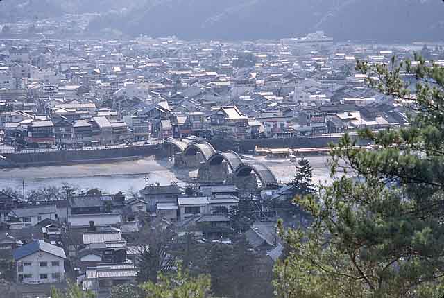
Iwakuni (岩国市, Iwakuni-shi) is a city located in Yamaguchi Prefecture, Japan. As of 1 June 2023[update], the city had an estimated population of 127,512 in 65182 households and a population density of 157 persons per km2. The total area of the city is 873.72 square kilometres (337.35 sq mi).
Iwakuni is located in the southeastern Yamaguchi Prefecture, bordering Hiroshima Prefecture to the east and the Seto Inland Sea to the south. The Nishiki River flows through the center of the city.
Hiroshima Prefecture
Shimane Prefecture
Yamaguchi Prefecture
Iwakuni has a humid subtropical climate (Köppen climate classification Cfa) with hot summers and cool winters. Precipitation is significant throughout the year, but is much higher from March to October, which encompasses the monsoon season from June to July, as well as peak typhoon season in September. The average annual temperature in Iwakuni is 15.1 °C (59.2 °F). The average annual rainfall is 1,781.4 mm (70.13 in) with July as the wettest month. The temperatures are highest on average in August, at around 26.9 °C (80.4 °F), and lowest in January, at around 4.2 °C (39.6 °F). The highest temperature ever recorded in Iwakuni was 39.0 °C (102.2 °F) on August 15, 2024; the coldest temperature ever recorded was −12.9 °C (8.8 °F) on February 19, 1977.
As of August 1, 2016, the city has an estimated population of 137,128 (which the city has decreased in population by 50,000 over the last 25 years) and a population density of 156.95 of persons per km2. The total area is 873.72 km2.
The area of present-day Iwakuni was part of the ancient Suō Province. During the Sengoku period, it was part of the holdings of the Mōri clan: however, after the defeat of the Western Army at the Battle of Sekigahara in 1600, the area around Iwakuni was granted to warlord Kikkawa Hiroie for his role in keeping the Mōri army from participating in the battle and thus preventing the complete attainder of the Mōri holdings under the Tokugawa shogunate. The Kikkawa clan built Iwakuni Castle and the core of the modern city developed from the castle town which arose around its ramparts. Iwakuni Domain had a kokudaka of 60,000 koku, but was regarded as a semi-independent component of Chōshū Domain until the Meiji restoration.
Iwakuni
Iwakuni (岩国市, Iwakuni-shi) is a city located in Yamaguchi Prefecture, Japan. As of 1 June 2023[update], the city had an estimated population of 127,512 in 65182 households and a population density of 157 persons per km2. The total area of the city is 873.72 square kilometres (337.35 sq mi).
Iwakuni is located in the southeastern Yamaguchi Prefecture, bordering Hiroshima Prefecture to the east and the Seto Inland Sea to the south. The Nishiki River flows through the center of the city.
Hiroshima Prefecture
Shimane Prefecture
Yamaguchi Prefecture
Iwakuni has a humid subtropical climate (Köppen climate classification Cfa) with hot summers and cool winters. Precipitation is significant throughout the year, but is much higher from March to October, which encompasses the monsoon season from June to July, as well as peak typhoon season in September. The average annual temperature in Iwakuni is 15.1 °C (59.2 °F). The average annual rainfall is 1,781.4 mm (70.13 in) with July as the wettest month. The temperatures are highest on average in August, at around 26.9 °C (80.4 °F), and lowest in January, at around 4.2 °C (39.6 °F). The highest temperature ever recorded in Iwakuni was 39.0 °C (102.2 °F) on August 15, 2024; the coldest temperature ever recorded was −12.9 °C (8.8 °F) on February 19, 1977.
As of August 1, 2016, the city has an estimated population of 137,128 (which the city has decreased in population by 50,000 over the last 25 years) and a population density of 156.95 of persons per km2. The total area is 873.72 km2.
The area of present-day Iwakuni was part of the ancient Suō Province. During the Sengoku period, it was part of the holdings of the Mōri clan: however, after the defeat of the Western Army at the Battle of Sekigahara in 1600, the area around Iwakuni was granted to warlord Kikkawa Hiroie for his role in keeping the Mōri army from participating in the battle and thus preventing the complete attainder of the Mōri holdings under the Tokugawa shogunate. The Kikkawa clan built Iwakuni Castle and the core of the modern city developed from the castle town which arose around its ramparts. Iwakuni Domain had a kokudaka of 60,000 koku, but was regarded as a semi-independent component of Chōshū Domain until the Meiji restoration.
Recent media
Recent media