
Recent from talks
Johnstown Flood
Knowledge base stats:
Talk channels stats:
Members stats:
Johnstown Flood
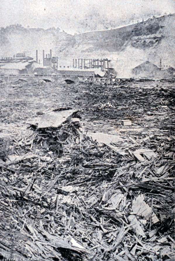
The Johnstown Flood, sometimes referred to locally as the Great Flood of 1889, occurred on Friday, May 31, 1889, after the catastrophic failure of the South Fork Dam, located on the south fork of the Little Conemaugh River, 14 miles (23 km) upstream of the town of Johnstown, Pennsylvania, United States. The dam ruptured after several days of extremely heavy rainfall, releasing 14.55 million cubic meters of water. With a volumetric flow rate that temporarily equaled the average flow rate of the Mississippi River, the flood killed 2,208 people and accounted for US$17,000,000 (equivalent to about $590,000,000 in 2024) in damage.
The American Red Cross, led by Clara Barton and with 50 volunteers, undertook a major disaster relief effort. Support for victims came from all over the United States and 18 foreign countries. After the flood, survivors suffered a series of legal defeats in their attempts to recover damages from the dam's owners. This led in the 20th century to American law changing from a fault-based regime to one of strict liability.
The events have been commemorated nationally as well as locally. The Johnstown Flood National Memorial was established in 1964. The National Historic Landmark District of the South Fork Fishing and Hunting Club was established in 1986. Both are administered by the National Park Service.
The city of Johnstown, Pennsylvania was founded in 1800 by Swiss immigrant Joseph Johns (anglicized from "Schantz") where the Stonycreek and Little Conemaugh rivers joined to form the Conemaugh River. It began to prosper with the building of the Pennsylvania Main Line Canal in 1836.
Construction of the Pennsylvania Railroad and the Cambria Iron Works in the 1850s brought further industry to town, and eventually led to abandonment of the canal. By 1889, Johnstown's industries had attracted numerous Welsh and German immigrants to work. With a population of 30,000, it was a growing industrial community known for the quality of its steel.
The high, steep hills of the narrow Conemaugh Valley and the Allegheny Mountains to the east restricted development of Johnstown, keeping it close to the riverfront areas. The valley received large amounts of runoff from rain and snowfall. The area surrounding the city is prone to flooding due to its location on the rivers, whose upstream watersheds include an extensive drainage basin of the Allegheny plateau. Adding to these factors, slag from the iron furnaces of the steel mills was dumped along the river to create more land for building and narrowed the riverbed. Developers' artificial narrowing of the riverbed to maximize early industries left the city even more flood-prone.
Immediately downstream of Johnstown, the Conemaugh River is hemmed in by steep mountainsides for about 10 miles (16 km). A roadside plaque alongside Pennsylvania Route 56, which follows this river, proclaims that this stretch of valley is the deepest river gorge in North America east of the Rocky Mountains.
High above the city, the Commonwealth of Pennsylvania built the South Fork Dam between 1838 and 1853 as part of a cross-state canal system, the Main Line of Public Works. Johnstown was the eastern terminus of the Western Division Canal, supplied with water by Lake Conemaugh, the reservoir behind the dam.
Hub AI
Johnstown Flood AI simulator
(@Johnstown Flood_simulator)
Johnstown Flood
The Johnstown Flood, sometimes referred to locally as the Great Flood of 1889, occurred on Friday, May 31, 1889, after the catastrophic failure of the South Fork Dam, located on the south fork of the Little Conemaugh River, 14 miles (23 km) upstream of the town of Johnstown, Pennsylvania, United States. The dam ruptured after several days of extremely heavy rainfall, releasing 14.55 million cubic meters of water. With a volumetric flow rate that temporarily equaled the average flow rate of the Mississippi River, the flood killed 2,208 people and accounted for US$17,000,000 (equivalent to about $590,000,000 in 2024) in damage.
The American Red Cross, led by Clara Barton and with 50 volunteers, undertook a major disaster relief effort. Support for victims came from all over the United States and 18 foreign countries. After the flood, survivors suffered a series of legal defeats in their attempts to recover damages from the dam's owners. This led in the 20th century to American law changing from a fault-based regime to one of strict liability.
The events have been commemorated nationally as well as locally. The Johnstown Flood National Memorial was established in 1964. The National Historic Landmark District of the South Fork Fishing and Hunting Club was established in 1986. Both are administered by the National Park Service.
The city of Johnstown, Pennsylvania was founded in 1800 by Swiss immigrant Joseph Johns (anglicized from "Schantz") where the Stonycreek and Little Conemaugh rivers joined to form the Conemaugh River. It began to prosper with the building of the Pennsylvania Main Line Canal in 1836.
Construction of the Pennsylvania Railroad and the Cambria Iron Works in the 1850s brought further industry to town, and eventually led to abandonment of the canal. By 1889, Johnstown's industries had attracted numerous Welsh and German immigrants to work. With a population of 30,000, it was a growing industrial community known for the quality of its steel.
The high, steep hills of the narrow Conemaugh Valley and the Allegheny Mountains to the east restricted development of Johnstown, keeping it close to the riverfront areas. The valley received large amounts of runoff from rain and snowfall. The area surrounding the city is prone to flooding due to its location on the rivers, whose upstream watersheds include an extensive drainage basin of the Allegheny plateau. Adding to these factors, slag from the iron furnaces of the steel mills was dumped along the river to create more land for building and narrowed the riverbed. Developers' artificial narrowing of the riverbed to maximize early industries left the city even more flood-prone.
Immediately downstream of Johnstown, the Conemaugh River is hemmed in by steep mountainsides for about 10 miles (16 km). A roadside plaque alongside Pennsylvania Route 56, which follows this river, proclaims that this stretch of valley is the deepest river gorge in North America east of the Rocky Mountains.
High above the city, the Commonwealth of Pennsylvania built the South Fork Dam between 1838 and 1853 as part of a cross-state canal system, the Main Line of Public Works. Johnstown was the eastern terminus of the Western Division Canal, supplied with water by Lake Conemaugh, the reservoir behind the dam.
Recent media