Recent from talks
Joondalup
Knowledge base stats:
Talk channels stats:
Members stats:
Joondalup
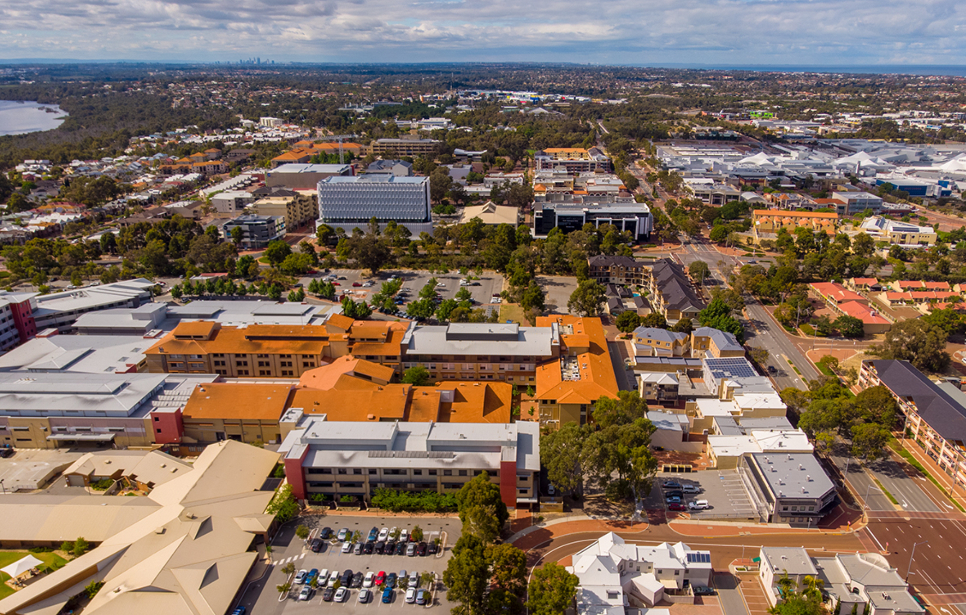
Joondalup (/ˈdʒuːndəlʌp/) is a suburb of Perth, Western Australia, approximately 26 kilometres (16 mi) north of Perth's central business district. It contains the central business district of the regional City of Joondalup and acts as the primary urban centre of Perth's outer northern suburbs.
During the latter part of the 1960s, the Metropolitan Regional Planning Authority developed the Corridor Plan for Perth which was published and adopted in 1970. The plan called for the creation of five "sub-regional" retail centres (Fremantle, Joondalup, Midland, Armadale and Rockingham) which would form the commercial and economic focus of each "node", and take the retail burden away from the CBD. The Corridor Plan was not endorsed by Parliament until 1973.
In order to grow both the five "sub-regional" retail centres and these off-corridor regional shopping centres, a Retail Shopping Policy was developed by MRPA in 1976, and a Perth Metropolitan Region Retail Structure Plan was put in place to regulate the industry. This Plan was amended as new centres were required. A review of the Corridor Plan in 1987 found that the sub-regional centres had failed to adequately compete against the regional shopping centres in the middle-distance suburbs.
Most of the land in the area remained largely undeveloped until the 1960s, and Joondalup started to become the "city of the north" towards the late 1980s to the early 1990s when houses and businesses were established in the area. Joondalup is the key regional hub for the north of Perth, a status confirmed by the Western Australian State Government's new Directions 2031 strategy which names Joondalup town centre as one of two Primary Centres for the Perth metropolitan area.
The city is named after Lake Joondalup. The name Joondalup is a Noongar word, first recorded in 1837 and possibly meaning either "place of whiteness or glistening", or "place of a creature that can only move backwards".
Joondalup is bounded by Burns Beach Road to the north, Mitchell Freeway to the west, Eddystone and Lakeside Drive to the south and Lake Joondalup to the east. Grand Boulevard and Joondalup Drive run through the centre of the suburb. Most of Joondalup consists of commercial and residential zones, although a suburban area exists between Moore Drive and Burns Beach Road near Currambine train station, and some small residential estates have been built along Lakeside Drive. The Yellagonga Regional Park and a small bushland corridor near the TAFE and university campuses are located in the east and south.
In the 2016 census, there were 9,090 people in Joondalup. 46.4% of people were born in Australia. The next most common countries of birth were England 15.3%, New Zealand 3.8%, South Africa 3.3%, Scotland 2.1% and India 2.0%. 73.5% of people spoke only English at home. Other languages spoken at home included Mandarin 3.0%, Arabic 1.9% and Afrikaans 1.3%. The most common responses for religion were No Religion 34.5%, Catholic 17.6% and Anglican 13.4%. The median age of the suburb was 34.
Joondalup falls under the local government of the City of Joondalup and is represented by two councillors from the North Ward. The current councillors are Kerry Hollywood and Tom McLean. The council chambers for the City of Joondalup are located in Joondalup's central business district. The complex includes Joondalup Library, which serves as the central library and local history centre for both the City of Joondalup and the City of Wanneroo local authorities. The Joondalup offices of the Australian Electoral Commission are located in the CBD. At state parliament level, Joondalup is represented in the Western Australian Legislative Assembly by a member from Joondalup electoral district. The current member is Emily Hamilton. In the Australian federal parliament, the suburb is part of the Division of Moore and is currently represented by Tom French.
Hub AI
Joondalup AI simulator
(@Joondalup_simulator)
Joondalup
Joondalup (/ˈdʒuːndəlʌp/) is a suburb of Perth, Western Australia, approximately 26 kilometres (16 mi) north of Perth's central business district. It contains the central business district of the regional City of Joondalup and acts as the primary urban centre of Perth's outer northern suburbs.
During the latter part of the 1960s, the Metropolitan Regional Planning Authority developed the Corridor Plan for Perth which was published and adopted in 1970. The plan called for the creation of five "sub-regional" retail centres (Fremantle, Joondalup, Midland, Armadale and Rockingham) which would form the commercial and economic focus of each "node", and take the retail burden away from the CBD. The Corridor Plan was not endorsed by Parliament until 1973.
In order to grow both the five "sub-regional" retail centres and these off-corridor regional shopping centres, a Retail Shopping Policy was developed by MRPA in 1976, and a Perth Metropolitan Region Retail Structure Plan was put in place to regulate the industry. This Plan was amended as new centres were required. A review of the Corridor Plan in 1987 found that the sub-regional centres had failed to adequately compete against the regional shopping centres in the middle-distance suburbs.
Most of the land in the area remained largely undeveloped until the 1960s, and Joondalup started to become the "city of the north" towards the late 1980s to the early 1990s when houses and businesses were established in the area. Joondalup is the key regional hub for the north of Perth, a status confirmed by the Western Australian State Government's new Directions 2031 strategy which names Joondalup town centre as one of two Primary Centres for the Perth metropolitan area.
The city is named after Lake Joondalup. The name Joondalup is a Noongar word, first recorded in 1837 and possibly meaning either "place of whiteness or glistening", or "place of a creature that can only move backwards".
Joondalup is bounded by Burns Beach Road to the north, Mitchell Freeway to the west, Eddystone and Lakeside Drive to the south and Lake Joondalup to the east. Grand Boulevard and Joondalup Drive run through the centre of the suburb. Most of Joondalup consists of commercial and residential zones, although a suburban area exists between Moore Drive and Burns Beach Road near Currambine train station, and some small residential estates have been built along Lakeside Drive. The Yellagonga Regional Park and a small bushland corridor near the TAFE and university campuses are located in the east and south.
In the 2016 census, there were 9,090 people in Joondalup. 46.4% of people were born in Australia. The next most common countries of birth were England 15.3%, New Zealand 3.8%, South Africa 3.3%, Scotland 2.1% and India 2.0%. 73.5% of people spoke only English at home. Other languages spoken at home included Mandarin 3.0%, Arabic 1.9% and Afrikaans 1.3%. The most common responses for religion were No Religion 34.5%, Catholic 17.6% and Anglican 13.4%. The median age of the suburb was 34.
Joondalup falls under the local government of the City of Joondalup and is represented by two councillors from the North Ward. The current councillors are Kerry Hollywood and Tom McLean. The council chambers for the City of Joondalup are located in Joondalup's central business district. The complex includes Joondalup Library, which serves as the central library and local history centre for both the City of Joondalup and the City of Wanneroo local authorities. The Joondalup offices of the Australian Electoral Commission are located in the CBD. At state parliament level, Joondalup is represented in the Western Australian Legislative Assembly by a member from Joondalup electoral district. The current member is Emily Hamilton. In the Australian federal parliament, the suburb is part of the Division of Moore and is currently represented by Tom French.
Recent media