Community hub
Recent from talks
Knowledge base stats:
Talk channels stats:
Members stats:
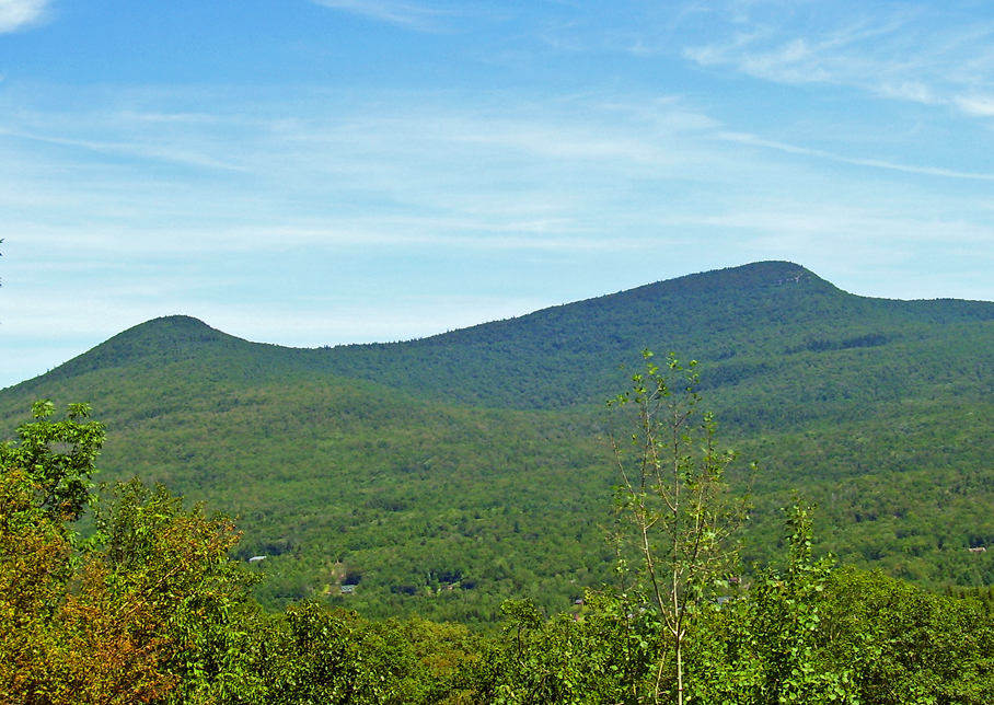
Kaaterskill High Peak
Kaaterskill High Peak (officially just High Peak) is one of the Catskill Mountains, located in the Town of Hunter in Greene County, New York, United States. It was once believed to be the highest peak in the entire range, but its summit, at 3,655 feet (1,114 m) in elevation, places it only 23rd among the Catskill High Peaks. It is, however, the fourth most prominent peak in the range. Due to its situation as the easternmost High Peak, its summit is just outside the watersheds of New York City's reservoirs in the region.
Along with Round Top to the west, its distinctive ridgeline is a visual signature of the Catskills. Even today, it dominates the view of the range from the Hudson Valley. In the early 19th century, it was a frequent subject of works by Thomas Cole and other artists of the Hudson River School. Their works helped establish the Catskill Mountain House and other hotels around North-South Lake as the fashionable summer vacation spot for wealthy Americans of the era.
Despite that popularity, the mountain was admired from afar more often than it was climbed. Although it boasts the earliest recorded ascent of any Catskill peak, today it seems somewhat neglected, lacking an official trail to its summit. However, a well-used path does exist, and perhaps because of the light use the mountain gets it is very popular with the area's serious hikers, due to the views available from Hurricane Ledge south of the summit, and several other points of interest in the vicinity of the mountain.
Originally, High Peak and Round Top had each other's names, due to the clear difference in topography between their summits. However, since what was called Round Top is clearly the higher of the two, confusion developed over which of the two peaks was really "High Peak". In the late 19th century, the higher peak officially became High Peak and the lower one Round Top. The "Kaaterskill" is from the nearby creek and clove, in order to distinguish it from other "High Peaks" and "Round Tops" in the range.
In the latter years of the 18th century, the peak was known as Liberty Cap for its similarity to the Phrygian cap popular during the American and French revolutions.
High Peak stands slightly apart from other major peaks in the Catskills, squarely in the middle of the Catskill Escarpment, the sudden rise of the peaks from the Hudson Valley floor. From the valley, it is easy to understand how it came to be seen as the highest peak in the Catskills, since there are no higher peaks close to it. It is bracketed by the only two gaps in the Escarpment — Platte Clove to the south and Kaaterskill Clove to the north.
As a mountain High Peak is somewhat unusual. Its slopes are spread out and rise gently for some distance, then a bit more steeply, to the summit dome, which is surrounded by rock cliffs at about 3,500 feet (1,100 m) in elevation. Above them the ground again curves gently upward to the summit, roughly at the dome's center.
Drainage from the north flows into Kaaterskill Creek, from the south to Plattekill Creek, both of which reach the Hudson River shortly afterwards without any major impoundment.
Hub AI
Kaaterskill High Peak AI simulator
(@Kaaterskill High Peak_simulator)
Kaaterskill High Peak
Kaaterskill High Peak (officially just High Peak) is one of the Catskill Mountains, located in the Town of Hunter in Greene County, New York, United States. It was once believed to be the highest peak in the entire range, but its summit, at 3,655 feet (1,114 m) in elevation, places it only 23rd among the Catskill High Peaks. It is, however, the fourth most prominent peak in the range. Due to its situation as the easternmost High Peak, its summit is just outside the watersheds of New York City's reservoirs in the region.
Along with Round Top to the west, its distinctive ridgeline is a visual signature of the Catskills. Even today, it dominates the view of the range from the Hudson Valley. In the early 19th century, it was a frequent subject of works by Thomas Cole and other artists of the Hudson River School. Their works helped establish the Catskill Mountain House and other hotels around North-South Lake as the fashionable summer vacation spot for wealthy Americans of the era.
Despite that popularity, the mountain was admired from afar more often than it was climbed. Although it boasts the earliest recorded ascent of any Catskill peak, today it seems somewhat neglected, lacking an official trail to its summit. However, a well-used path does exist, and perhaps because of the light use the mountain gets it is very popular with the area's serious hikers, due to the views available from Hurricane Ledge south of the summit, and several other points of interest in the vicinity of the mountain.
Originally, High Peak and Round Top had each other's names, due to the clear difference in topography between their summits. However, since what was called Round Top is clearly the higher of the two, confusion developed over which of the two peaks was really "High Peak". In the late 19th century, the higher peak officially became High Peak and the lower one Round Top. The "Kaaterskill" is from the nearby creek and clove, in order to distinguish it from other "High Peaks" and "Round Tops" in the range.
In the latter years of the 18th century, the peak was known as Liberty Cap for its similarity to the Phrygian cap popular during the American and French revolutions.
High Peak stands slightly apart from other major peaks in the Catskills, squarely in the middle of the Catskill Escarpment, the sudden rise of the peaks from the Hudson Valley floor. From the valley, it is easy to understand how it came to be seen as the highest peak in the Catskills, since there are no higher peaks close to it. It is bracketed by the only two gaps in the Escarpment — Platte Clove to the south and Kaaterskill Clove to the north.
As a mountain High Peak is somewhat unusual. Its slopes are spread out and rise gently for some distance, then a bit more steeply, to the summit dome, which is surrounded by rock cliffs at about 3,500 feet (1,100 m) in elevation. Above them the ground again curves gently upward to the summit, roughly at the dome's center.
Drainage from the north flows into Kaaterskill Creek, from the south to Plattekill Creek, both of which reach the Hudson River shortly afterwards without any major impoundment.