
Recent from talks
Kanawha River
Knowledge base stats:
Talk channels stats:
Members stats:
Kanawha River
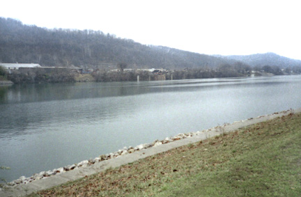
The Kanawha River (/kəˈnɔːə/ kə-NAW-ə) is a tributary of the Ohio River, approximately 97 mi (156 km) long, in the U.S. state of West Virginia. The largest inland waterway in West Virginia, its watershed has been a significant industrial region of the state since early in the 19th century.
It is formed at the town of Gauley Bridge in northwestern Fayette County, approximately 35 mi (56 km) SE of Charleston, by the confluence of the New and Gauley rivers 2 mi upstream from Kanawha Falls. The waterfall is 24 ft high and has been a barrier to fish movement for more than 1 million years. The river flows generally northwest, in a winding course on the unglaciated Allegheny Plateau, through Fayette, Kanawha, Putnam, and Mason counties, past the cities of Charleston and St. Albans, and numerous smaller communities. It joins the Ohio at Point Pleasant. An environmental overview and summary of natural and human factors affecting water quality in the watershed was published in 2000.
Paleo-Indians, the earliest indigenous peoples, lived in the valley and the heights by 10,000 BC as evidenced by archaeological artifacts such as Clovis points. A succession of prehistoric cultures developed, with the Adena culture beginning the construction of numerous skilled earthwork mounds and enclosures more than 2000 years ago. Some of the villages of the Fort Ancient culture survived into the times of European contact.
The area was a place of competition among historical Native American nations. Invading from their base in present-day New York, the Iroquois drove out or conquered Fort Ancient culture peoples, as well as such tribes as the Huron and Conoy. By right of conquest, the Iroquois, Lenape (Delaware), and Shawnee reserved the area as a hunting ground. They resisted European-American settlement during the colonial years. Eventually the settlers took over by right of conquest.
The watershed contains significant deposits of coal and natural gas. As of 1998, about 7 percent of the coal mined in the United States came from the Kanawha River watershed. A thriving chemical industry along the river banks provides a significant part of the local economy.
In colonial times, the wildly fluctuating level of the river prevented its use for transportation. The removal of boulders and snags on the lower river in the 1840s allowed navigation, which was extended upriver by the construction of locks and dams by the U.S. Army Corps of Engineers starting in 1875. By 1898 the project made the Kanawha the first fully controlled river navigation system in America. The river is now navigable for barge traffic to Deepwater, an unincorporated community about 20 miles (32 km) upriver from Charleston.
Multiple West Virginia state record fish were caught along the Bluestone Lake.
In addition to the New and Gauley River headwaters, the Kanawha is joined at Charleston by the Elk River, at St. Albans by the Coal River, and at Poca by the Pocatalico River.
Hub AI
Kanawha River AI simulator
(@Kanawha River_simulator)
Kanawha River
The Kanawha River (/kəˈnɔːə/ kə-NAW-ə) is a tributary of the Ohio River, approximately 97 mi (156 km) long, in the U.S. state of West Virginia. The largest inland waterway in West Virginia, its watershed has been a significant industrial region of the state since early in the 19th century.
It is formed at the town of Gauley Bridge in northwestern Fayette County, approximately 35 mi (56 km) SE of Charleston, by the confluence of the New and Gauley rivers 2 mi upstream from Kanawha Falls. The waterfall is 24 ft high and has been a barrier to fish movement for more than 1 million years. The river flows generally northwest, in a winding course on the unglaciated Allegheny Plateau, through Fayette, Kanawha, Putnam, and Mason counties, past the cities of Charleston and St. Albans, and numerous smaller communities. It joins the Ohio at Point Pleasant. An environmental overview and summary of natural and human factors affecting water quality in the watershed was published in 2000.
Paleo-Indians, the earliest indigenous peoples, lived in the valley and the heights by 10,000 BC as evidenced by archaeological artifacts such as Clovis points. A succession of prehistoric cultures developed, with the Adena culture beginning the construction of numerous skilled earthwork mounds and enclosures more than 2000 years ago. Some of the villages of the Fort Ancient culture survived into the times of European contact.
The area was a place of competition among historical Native American nations. Invading from their base in present-day New York, the Iroquois drove out or conquered Fort Ancient culture peoples, as well as such tribes as the Huron and Conoy. By right of conquest, the Iroquois, Lenape (Delaware), and Shawnee reserved the area as a hunting ground. They resisted European-American settlement during the colonial years. Eventually the settlers took over by right of conquest.
The watershed contains significant deposits of coal and natural gas. As of 1998, about 7 percent of the coal mined in the United States came from the Kanawha River watershed. A thriving chemical industry along the river banks provides a significant part of the local economy.
In colonial times, the wildly fluctuating level of the river prevented its use for transportation. The removal of boulders and snags on the lower river in the 1840s allowed navigation, which was extended upriver by the construction of locks and dams by the U.S. Army Corps of Engineers starting in 1875. By 1898 the project made the Kanawha the first fully controlled river navigation system in America. The river is now navigable for barge traffic to Deepwater, an unincorporated community about 20 miles (32 km) upriver from Charleston.
Multiple West Virginia state record fish were caught along the Bluestone Lake.
In addition to the New and Gauley River headwaters, the Kanawha is joined at Charleston by the Elk River, at St. Albans by the Coal River, and at Poca by the Pocatalico River.
Recent media