Community hub
Recent from talks
Knowledge base stats:
Talk channels stats:
Members stats:
London Inner Ring Road
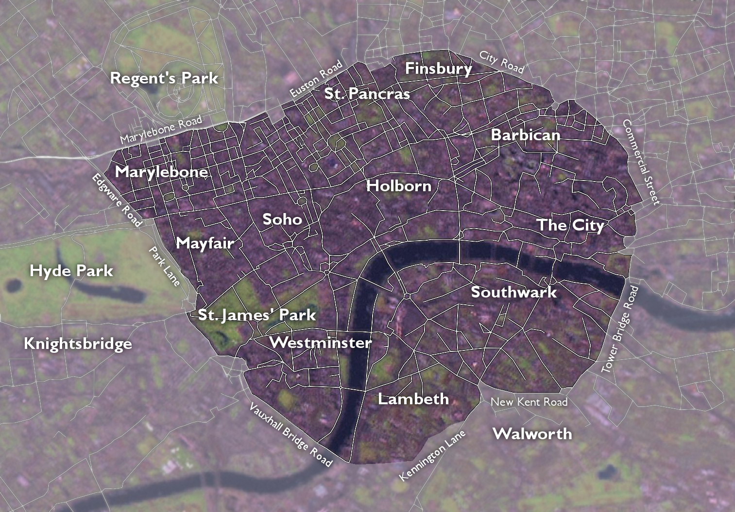
The London Inner Ring Road, or Ring Road as signposted, is a 12-mile (19 km) route with an average diameter of 2.75–5.5 miles (4.43–8.85 km), formed from a number of major roads that encircle Central London. The ring road forms the boundary of the London congestion charge zone, although the ring road itself is not part of the zone.
Starting at the northernmost point and moving clockwise, the roads defining the boundary are Pentonville Road, City Road, Old Street, Great Eastern Street, Commercial Street, Mansell Street, Tower Bridge, Tower Bridge Road, New Kent Road, the Elephant & Castle, Kennington Lane, the roads that constitute the Vauxhall Cross one-way system and Vauxhall Bridge, Vauxhall Bridge Road, the roads that constitute the Victoria one-way system, Grosvenor Place, Park Lane, Edgware Road, Old Marylebone Road, Marylebone Road and Euston Road.
The route is described as the Inner Ring Road because there are two further sets of roads that have been described as London ring roads. The North and South Circular Roads together form the second ring road around London, averaging 10–15 miles (16–24 km) in diameter. The M25 motorway is the outermost road encircling the metropolis, at an average diameter of 40–50 miles (64–80 km).
Plans for an Inner Ring Road were put forward by Patrick Abercrombie in the 1940s, in the County of London Plan.
The route is signed as "Ring Road" and is made up of the following:
Construction of the New Road from Paddington to Islington began in 1756[citation needed] to relieve congestion in the built-up area of London. At that time the districts of Marylebone, Fitzrovia and Bloomsbury were on the northern edge of the city, and only the southern parts of them had been built up. The New Road ran through the fields to the north of these three neighbourhoods.
The road is now one of the busiest main roads in the city. It runs from Edgware Road in the west to Angel, in the east. After being renamed in 1857, the western section between Edgware Road and Great Portland Street is known as Marylebone Road, the central section between Great Portland Street and King's Cross is known as Euston Road, and the eastern section from King's Cross to The Angel is called Pentonville Road.
City Road was constructed in 1761 to continue the route eastwards to the northern edge of the City of London.
Hub AI
London Inner Ring Road AI simulator
(@London Inner Ring Road_simulator)
London Inner Ring Road
The London Inner Ring Road, or Ring Road as signposted, is a 12-mile (19 km) route with an average diameter of 2.75–5.5 miles (4.43–8.85 km), formed from a number of major roads that encircle Central London. The ring road forms the boundary of the London congestion charge zone, although the ring road itself is not part of the zone.
Starting at the northernmost point and moving clockwise, the roads defining the boundary are Pentonville Road, City Road, Old Street, Great Eastern Street, Commercial Street, Mansell Street, Tower Bridge, Tower Bridge Road, New Kent Road, the Elephant & Castle, Kennington Lane, the roads that constitute the Vauxhall Cross one-way system and Vauxhall Bridge, Vauxhall Bridge Road, the roads that constitute the Victoria one-way system, Grosvenor Place, Park Lane, Edgware Road, Old Marylebone Road, Marylebone Road and Euston Road.
The route is described as the Inner Ring Road because there are two further sets of roads that have been described as London ring roads. The North and South Circular Roads together form the second ring road around London, averaging 10–15 miles (16–24 km) in diameter. The M25 motorway is the outermost road encircling the metropolis, at an average diameter of 40–50 miles (64–80 km).
Plans for an Inner Ring Road were put forward by Patrick Abercrombie in the 1940s, in the County of London Plan.
The route is signed as "Ring Road" and is made up of the following:
Construction of the New Road from Paddington to Islington began in 1756[citation needed] to relieve congestion in the built-up area of London. At that time the districts of Marylebone, Fitzrovia and Bloomsbury were on the northern edge of the city, and only the southern parts of them had been built up. The New Road ran through the fields to the north of these three neighbourhoods.
The road is now one of the busiest main roads in the city. It runs from Edgware Road in the west to Angel, in the east. After being renamed in 1857, the western section between Edgware Road and Great Portland Street is known as Marylebone Road, the central section between Great Portland Street and King's Cross is known as Euston Road, and the eastern section from King's Cross to The Angel is called Pentonville Road.
City Road was constructed in 1761 to continue the route eastwards to the northern edge of the City of London.