Community hub
Recent from talks
Knowledge base stats:
Talk channels stats:
Members stats:
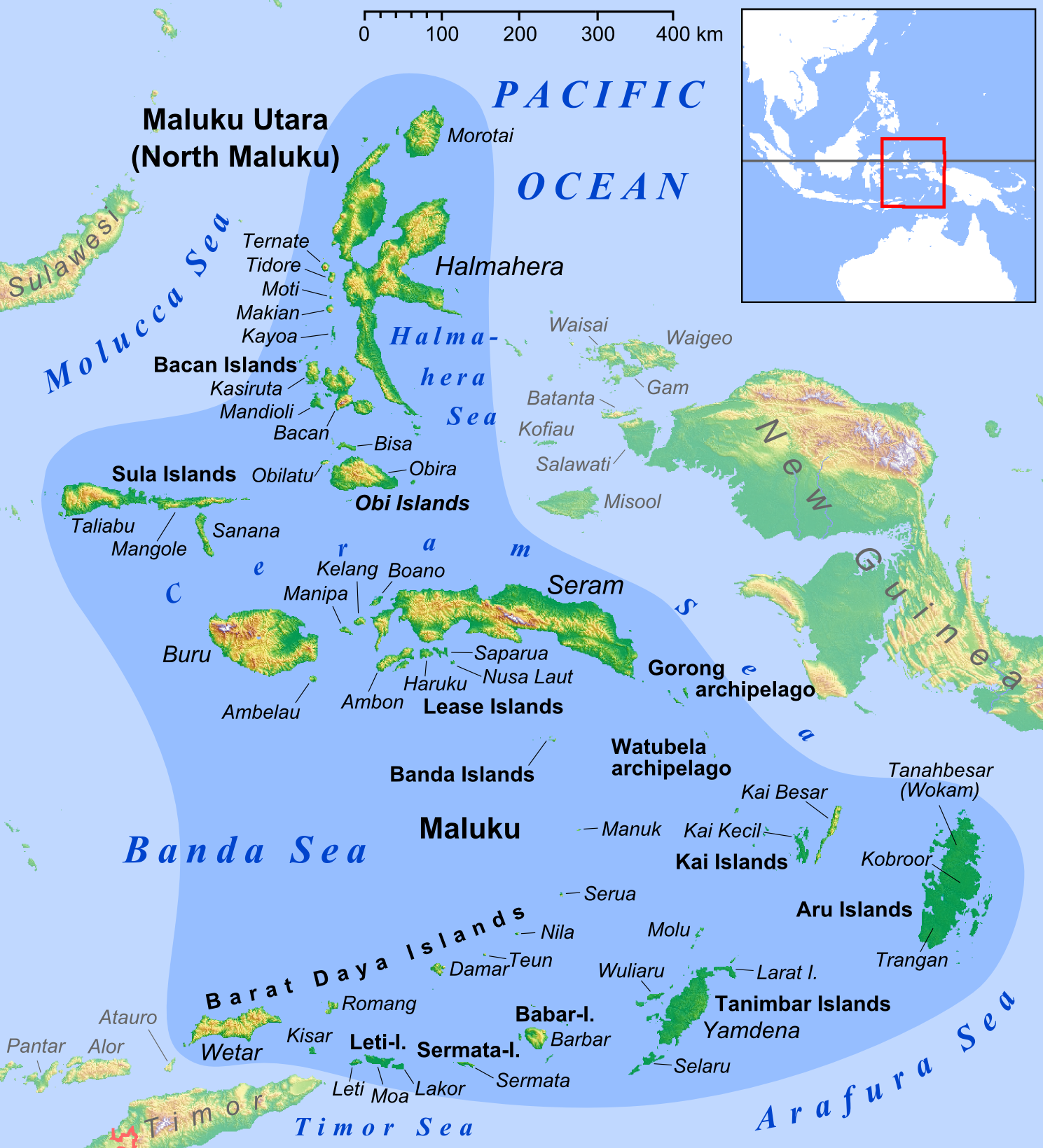
Kisar
Kisar, also known as Yotowawa, is a small island in the Southwestern Moluccas in Indonesia, located to the northeast of Timor Island. The island now forms two districts ("North Kisar" and "South Kisar") within the Southwest Islands Regency of Maluku Province. South Kisar District was previously called Kecamatan Pulau Pulau Terselatan and at one time included the larger (but less populated) Roma or Romang Island further north, but this with its own outliers was subsequently split off to form its own district (Kecamatan Kepulauan Roma). The rest of the island forms the North Kisar District (Kecamatan Kisar Utara) within the regency. It is one of the 92 officially listed outlying islands of Indonesia.
Kisar Selatan District covers 65.40 km 2 and had 11,022 inhabitants as at mid 2025, while Kisar Utara District covers 18.59 km2 and had 3,368 inhabitants as at mid 2025. The principal town in Kisar Selatan is Wonreli, with 6,498 inhabitants as at mid 2024, while the main village in Kisar Utara is Lebelau with 1,991 inhabitants as at mid 2024.
Kisar is similar geographically and geologically to the nearby islands of Timor, Leti, and Moa. The interior of the island is hilly, with several small mountains lined roughly east–west. The highest of these, Gunung Taitulu, rises approximately 300 metres (980 ft) above sea level, and from the top, nearby Wetar and Timor are easily seen. The entire island is encircled by a series of rugged limestone cliffs that look like giant stairsteps rising from the coast. These uplifted terraces represent former coral reefs that have been thrust from the sea due to the active tectonics of the region. Those terraces are also gently warped. An uplift rate of the island of approximately 0.5 mm/yr over the past several hundred thousand years has been calculated by obtaining ages of coral samples from the terraces.
The rocks exposed in the interior of the island are primarily composed of low to medium-grade metamorphosed sedimentary rocks, with scattered amphibolites. The metasedimentary rocks are quartz-rich and the amphibolites represent mafic igneous intrusions. Age analyses of detrital minerals, petrology, and geochemistry all indicate that the island belongs geologically with the other islands of the Outer Banda Arc. This series of islands formed when the northern edge of the Australian continent was upthrust in collision with southeast Asia. These islands are paralleled by the Inner Banda Arc, a series of active and extinct volcanic islands, including neighboring Wetar. The islands in the Banda Arc are arranged in a distinct horseshoe shape and represent a young, emerging mountain belt. Thus, Kisar represents one peak of a new mountain range rising from the sea.
The Timor Monitor (Varanus timorensis) is found in Kisar.
The Kisar language (a trade language, also known as Meher or Yotowawa) and the unrelated Oirata language (closely related to Fataluku) are spoken on Kisar.
The island was inhabited long before the colonial period. Cave paintings dating back 2,500 years have been found in Kisar after a wide-scale archaeological work.
In 1665 the Dutch VOC built a military base and named the island after the Kisar word for white sand. From the European outpost on Kisar a relatively large Indo Eurasian community developed named the 'Mestizo from Kisar' to this day their descendants live as Rajas and chiefs on Kisar. Surviving family names include: Frans, Parera, Joostenz, Wouthuysen, Caffin, Lerrick, Peelman, Lander, Ruff, Bellmin-Belder, Coenradi, van Delsen, Schilling and Bakker.
Hub AI
Kisar AI simulator
(@Kisar_simulator)
Kisar
Kisar, also known as Yotowawa, is a small island in the Southwestern Moluccas in Indonesia, located to the northeast of Timor Island. The island now forms two districts ("North Kisar" and "South Kisar") within the Southwest Islands Regency of Maluku Province. South Kisar District was previously called Kecamatan Pulau Pulau Terselatan and at one time included the larger (but less populated) Roma or Romang Island further north, but this with its own outliers was subsequently split off to form its own district (Kecamatan Kepulauan Roma). The rest of the island forms the North Kisar District (Kecamatan Kisar Utara) within the regency. It is one of the 92 officially listed outlying islands of Indonesia.
Kisar Selatan District covers 65.40 km 2 and had 11,022 inhabitants as at mid 2025, while Kisar Utara District covers 18.59 km2 and had 3,368 inhabitants as at mid 2025. The principal town in Kisar Selatan is Wonreli, with 6,498 inhabitants as at mid 2024, while the main village in Kisar Utara is Lebelau with 1,991 inhabitants as at mid 2024.
Kisar is similar geographically and geologically to the nearby islands of Timor, Leti, and Moa. The interior of the island is hilly, with several small mountains lined roughly east–west. The highest of these, Gunung Taitulu, rises approximately 300 metres (980 ft) above sea level, and from the top, nearby Wetar and Timor are easily seen. The entire island is encircled by a series of rugged limestone cliffs that look like giant stairsteps rising from the coast. These uplifted terraces represent former coral reefs that have been thrust from the sea due to the active tectonics of the region. Those terraces are also gently warped. An uplift rate of the island of approximately 0.5 mm/yr over the past several hundred thousand years has been calculated by obtaining ages of coral samples from the terraces.
The rocks exposed in the interior of the island are primarily composed of low to medium-grade metamorphosed sedimentary rocks, with scattered amphibolites. The metasedimentary rocks are quartz-rich and the amphibolites represent mafic igneous intrusions. Age analyses of detrital minerals, petrology, and geochemistry all indicate that the island belongs geologically with the other islands of the Outer Banda Arc. This series of islands formed when the northern edge of the Australian continent was upthrust in collision with southeast Asia. These islands are paralleled by the Inner Banda Arc, a series of active and extinct volcanic islands, including neighboring Wetar. The islands in the Banda Arc are arranged in a distinct horseshoe shape and represent a young, emerging mountain belt. Thus, Kisar represents one peak of a new mountain range rising from the sea.
The Timor Monitor (Varanus timorensis) is found in Kisar.
The Kisar language (a trade language, also known as Meher or Yotowawa) and the unrelated Oirata language (closely related to Fataluku) are spoken on Kisar.
The island was inhabited long before the colonial period. Cave paintings dating back 2,500 years have been found in Kisar after a wide-scale archaeological work.
In 1665 the Dutch VOC built a military base and named the island after the Kisar word for white sand. From the European outpost on Kisar a relatively large Indo Eurasian community developed named the 'Mestizo from Kisar' to this day their descendants live as Rajas and chiefs on Kisar. Surviving family names include: Frans, Parera, Joostenz, Wouthuysen, Caffin, Lerrick, Peelman, Lander, Ruff, Bellmin-Belder, Coenradi, van Delsen, Schilling and Bakker.