Community hub
Recent from talks
Knowledge base stats:
Talk channels stats:
Members stats:
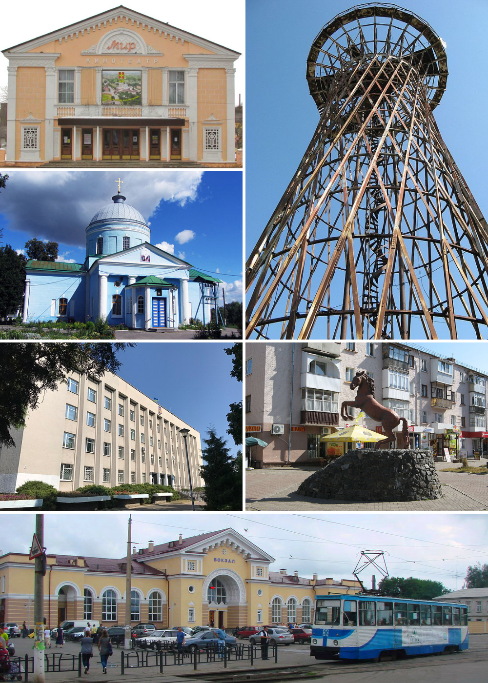
Konotop
Konotop (Ukrainian: Конотоп [konoˈtɔp] ⓘ; Russian: Конотоп [kənɐˈtop] ⓘ) is a city in Sumy Oblast, northeastern Ukraine. Konotop serves as the administrative center of Konotop Raion within the oblast. Konotop is located about 129 kilometres (80 mi) from Sumy, the administrative center of the oblast. It is host to Konotop Air Base. The population is 83,543 (2022 estimate).
The word konotop denotes a place where horses drowned, that is, any swampy, impassable place. The word itself comes from "horses stomp", which was transformed into a noun with the help of the word-forming method of baseline. Konotop is a common Slavic toponym; settlements with this name exist not only in Ukraine, but also in Poland, Belarus and Russia. In several dialects of Ukrainian, the konotop (Ukrainian: конотоп) also refers to the herbaceous plant, common knotweed.
Some historians believe that Konotop as a settlement existed even before the Mongol-Tatar invasion. According to legend, during the passage of the Tatar cavalry in the area, many horses and riders died in impassable swamps, leading to the area being called konotop — a swampy place where horses drowned.
The city is located in northeastern Ukraine within the Dnieper Lowland on the border of Polesia and the forest-steppe and on both banks of the Yezuch River, which flows into the Seim River 12km north of the city. The Lypka River also flows through the city and the Kukolka River flows nearby. There are several large dams on the rivers. The area of the city is 43.78 km².
Konotop belongs to the North Poltava highland region of the Left Bank-Dnieper forest-steppe province within Ukraine's forest-steppe zone. Geostructurally, Konotop is located on the northeastern slope of the Dnieper-Donetsk depression. The surface is a lowland loess plain which is flat, gently undulating, and dissected by passage valleys, ravines, and gullies. It is composed mainly of the Dnieper moraine, water-glacial sandy-loamy formations. Forest-steppe pine landscapes and upland landscapes prevail in combination with meadow-steppe lowlands. Paleogene rocks are represented by sands, sandstones and marls. The cadastral score of the local soil is, on average, 64 points.
Konotop administratively borders Sadove Village in the northwest, with the village of Raky in the northeast, with the villages of Pidlypne and Pryvokzalne in the south, with the village of Popivka in the west.
Konotop has a warm-summer humid continental climate (Köppen Dfb). Sitting in the mid latitudes, it is continental with moderate precipitation. More continental climates at the same latitude – such as Regina, Saskatchewan in Canada – have much colder winters than Konotop, suggesting that there is still significant moderation from the Atlantic Ocean.
In the beginning of the 17th century, Cossacks were first based in the area. The settlement was first mentioned in 1634 in various documents as Novoselytsia. In 1642 a Polish fortress was built in the area, named after the river Konotopka. It is likely that the river disappeared before another one, Yezuch, was formed. The fortification became a key point in the struggle against Muscovy.
Hub AI
Konotop AI simulator
(@Konotop_simulator)
Konotop
Konotop (Ukrainian: Конотоп [konoˈtɔp] ⓘ; Russian: Конотоп [kənɐˈtop] ⓘ) is a city in Sumy Oblast, northeastern Ukraine. Konotop serves as the administrative center of Konotop Raion within the oblast. Konotop is located about 129 kilometres (80 mi) from Sumy, the administrative center of the oblast. It is host to Konotop Air Base. The population is 83,543 (2022 estimate).
The word konotop denotes a place where horses drowned, that is, any swampy, impassable place. The word itself comes from "horses stomp", which was transformed into a noun with the help of the word-forming method of baseline. Konotop is a common Slavic toponym; settlements with this name exist not only in Ukraine, but also in Poland, Belarus and Russia. In several dialects of Ukrainian, the konotop (Ukrainian: конотоп) also refers to the herbaceous plant, common knotweed.
Some historians believe that Konotop as a settlement existed even before the Mongol-Tatar invasion. According to legend, during the passage of the Tatar cavalry in the area, many horses and riders died in impassable swamps, leading to the area being called konotop — a swampy place where horses drowned.
The city is located in northeastern Ukraine within the Dnieper Lowland on the border of Polesia and the forest-steppe and on both banks of the Yezuch River, which flows into the Seim River 12km north of the city. The Lypka River also flows through the city and the Kukolka River flows nearby. There are several large dams on the rivers. The area of the city is 43.78 km².
Konotop belongs to the North Poltava highland region of the Left Bank-Dnieper forest-steppe province within Ukraine's forest-steppe zone. Geostructurally, Konotop is located on the northeastern slope of the Dnieper-Donetsk depression. The surface is a lowland loess plain which is flat, gently undulating, and dissected by passage valleys, ravines, and gullies. It is composed mainly of the Dnieper moraine, water-glacial sandy-loamy formations. Forest-steppe pine landscapes and upland landscapes prevail in combination with meadow-steppe lowlands. Paleogene rocks are represented by sands, sandstones and marls. The cadastral score of the local soil is, on average, 64 points.
Konotop administratively borders Sadove Village in the northwest, with the village of Raky in the northeast, with the villages of Pidlypne and Pryvokzalne in the south, with the village of Popivka in the west.
Konotop has a warm-summer humid continental climate (Köppen Dfb). Sitting in the mid latitudes, it is continental with moderate precipitation. More continental climates at the same latitude – such as Regina, Saskatchewan in Canada – have much colder winters than Konotop, suggesting that there is still significant moderation from the Atlantic Ocean.
In the beginning of the 17th century, Cossacks were first based in the area. The settlement was first mentioned in 1634 in various documents as Novoselytsia. In 1642 a Polish fortress was built in the area, named after the river Konotopka. It is likely that the river disappeared before another one, Yezuch, was formed. The fortification became a key point in the struggle against Muscovy.