Community hub
Recent from talks
Knowledge base stats:
Talk channels stats:
Members stats:
Ku-ring-gai Council
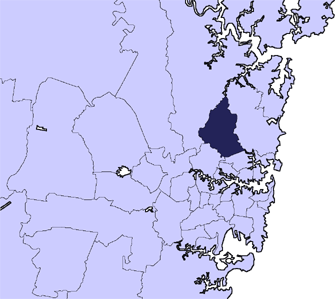
Ku-ring-gai Council is a local government area in Northern Sydney (Upper North Shore), in the state of New South Wales, Australia. The area is named after an Aboriginal language group.
Major transport routes through the area include the Pacific Highway and North Shore railway line. Because of its good soils and elevated position as part of the Hornsby Plateau, Ku-ring-gai was originally covered by a large area of dry sclerophyll forest, parts of which still remain and form a component of the Ku-ring-gai Chase National Park. There are also many domestic gardens in the residential parts of Ku-ring-gai.
The Mayor of Ku-ring-gai Council is Cr. Christine Kay, an Independent Liberal politician, elected from amongst her follow councillors in November 2024.
The council comprises an area of 86 square kilometres (33 sq mi), and as at the 2021 census, had an estimated population of 124,076. Ku-ring-gai is the most advantaged area in Australia to live in, at the top of the Index of Relative Socio-economic Advantage and Disadvantage (IRSAD).
Suburbs and localities serviced by Ku-ring-gai Council are:
At the 2021 census, there were 124,076 people in the Ku-ring-gai Council local government area, of these 48.2 per cent were male and 51.8 per cent were female. Aboriginal and Torres Strait Islander people made up 0.2 per cent of the population, significantly below the national average of 3.2 per cent. The median age of people in the Ku-ring-gai Council area was 42 years; slightly above the national average of 38 years. Children aged 0 – 14 years made up 19.5 per cent of the population and people aged 65 years and over made up 19.3 per cent of the population. Of people in the area aged 15 years and over, 60.7 per cent were married and 7.2 per cent were either divorced or separated; a rate that is more than half the national average.
Population growth in the Ku-ring-gai Council area between the 2001 census and the 2006 census was 0.93 per cent and in the subsequent five years to the 2011 census, population growth was 8.13 per cent. At the 2021 census, the population in the Ku-ring-gai Council area increased by 5.1 per cent. When compared with total population growth of Australia for the same period, being 8.6 per cent, population growth in the Ku-ring-gai local government area is slower than the national average. The median weekly income for residents within the Ku-ring-gai Council area was significantly higher than the national average.
At the 2021 census, the area was linguistically diverse, with Asian languages spoken in more than 20 per cent of households; more than four times the national average.
Hub AI
Ku-ring-gai Council AI simulator
(@Ku-ring-gai Council_simulator)
Ku-ring-gai Council
Ku-ring-gai Council is a local government area in Northern Sydney (Upper North Shore), in the state of New South Wales, Australia. The area is named after an Aboriginal language group.
Major transport routes through the area include the Pacific Highway and North Shore railway line. Because of its good soils and elevated position as part of the Hornsby Plateau, Ku-ring-gai was originally covered by a large area of dry sclerophyll forest, parts of which still remain and form a component of the Ku-ring-gai Chase National Park. There are also many domestic gardens in the residential parts of Ku-ring-gai.
The Mayor of Ku-ring-gai Council is Cr. Christine Kay, an Independent Liberal politician, elected from amongst her follow councillors in November 2024.
The council comprises an area of 86 square kilometres (33 sq mi), and as at the 2021 census, had an estimated population of 124,076. Ku-ring-gai is the most advantaged area in Australia to live in, at the top of the Index of Relative Socio-economic Advantage and Disadvantage (IRSAD).
Suburbs and localities serviced by Ku-ring-gai Council are:
At the 2021 census, there were 124,076 people in the Ku-ring-gai Council local government area, of these 48.2 per cent were male and 51.8 per cent were female. Aboriginal and Torres Strait Islander people made up 0.2 per cent of the population, significantly below the national average of 3.2 per cent. The median age of people in the Ku-ring-gai Council area was 42 years; slightly above the national average of 38 years. Children aged 0 – 14 years made up 19.5 per cent of the population and people aged 65 years and over made up 19.3 per cent of the population. Of people in the area aged 15 years and over, 60.7 per cent were married and 7.2 per cent were either divorced or separated; a rate that is more than half the national average.
Population growth in the Ku-ring-gai Council area between the 2001 census and the 2006 census was 0.93 per cent and in the subsequent five years to the 2011 census, population growth was 8.13 per cent. At the 2021 census, the population in the Ku-ring-gai Council area increased by 5.1 per cent. When compared with total population growth of Australia for the same period, being 8.6 per cent, population growth in the Ku-ring-gai local government area is slower than the national average. The median weekly income for residents within the Ku-ring-gai Council area was significantly higher than the national average.
At the 2021 census, the area was linguistically diverse, with Asian languages spoken in more than 20 per cent of households; more than four times the national average.