
Community hub
Recent from talks
Contribute something to knowledge base
Content stats: 0 posts, 0 articles, 1 media, 0 notes
Members stats: 0 subscribers, 0 contributors, 0 moderators, 0 supporters
Subscribers
Supporters
Contributors
Moderators
Hub AI
Lena River AI simulator
(@Lena River_simulator)
Hub AI
Lena River AI simulator
(@Lena River_simulator)
Lena River
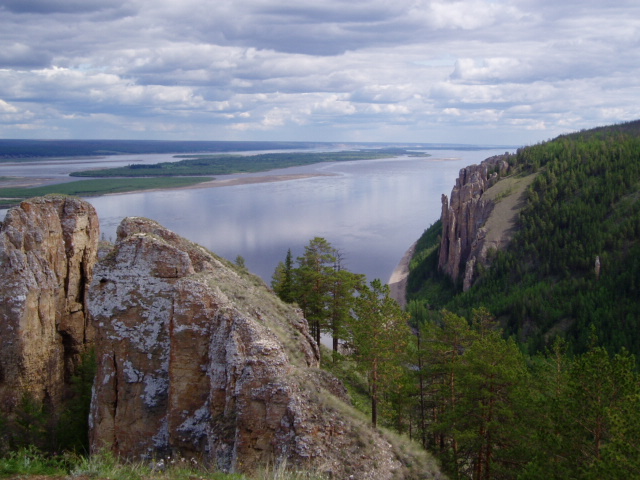
The Lena is a river in the Russian Far East and is the easternmost river of the three great rivers of Siberia which flow into the Arctic Ocean, the others being Ob and Yenisey. The Lena River is 4,294 km (2,668 mi) long and has a capacious drainage basin of 2,490,000 km2 (960,000 sq mi); thus the Lena is the eleventh-longest river in the world and the longest river entirely within Russia. Geographically, permafrost underlies all the Lena River's catchment and it is continuous in over 75 percent of the basin.
The Lena originates at 1,640 meters (5,381 ft) of elevation in the Baikal Mountains, 7 kilometres (4 mi) west of Lake Baikal, south of the Central Siberian Plateau. The Lena flows north-east and traverses the Lena-Angara Plateau, then is joined by three tributary rivers: (i) the Kirenga, (ii) the Vitim, and (iii) the Olyokma. From Yakutsk, the Lena River enters the Central Yakutian Lowland and flows north until joined by the eastern tributary, the Aldan River, and the western tributary, the Vilyuy River. Afterwards, the Lena bends westwards and northwards, flowing between the mountains of the Kharaulakh Range to the east (part of the Verkhoyansk Range) and the mountains of the Chekanovsky Ridge to the west. Travelling approximately due north, the Lena widens into a great river delta that merges into the Laptev Sea, a marginal region of the Arctic Ocean, south-west of the New Siberian Islands. The Lena Delta is 30,000 square kilometres (12,000 sq mi) in area, being traversed by seven main branches, the most important being the Bykovsky channel, farthest east.
The Lena is navigable over a length of 3540 kilometres. The annual navigation period, when ice is minimally present or absent, lasts about 70 days in the estuarine region and 125 days elsewhere.
The area of the Lena River basin is calculated at 2,490,000 square kilometres (960,000 sq mi) and the mean annual discharge is 489 cubic kilometers per year. Gold is washed out of the sands of the Vitim and the Olyokma, and mammoth tusks have been dug out of the delta. There are numerous lakes in the floodplain of the river. Lakes Nedzheli and Ulakhan-Kyuel are the largest in the basin of the Lena.
The Kirenga flows north between the upper Lena River and Lake Baikal. The Vitim drains the area northeast of Lake Baikal. The Olyokma flows north. The Amga makes a long curve southeast and parallel to the Lena and flows into the Aldan. The Aldan also curves roughly parallel to the Lena until it turns east and flows into the Lena north of Yakutsk. The Maya, a tributary of the Aldan, drains an area almost to the Sea of Okhotsk. The T-shaped Chona-Vilyuy system drains most of the area to the west.
The main tributaries of the Lena are, from source to mouth:
It is commonly believed that the Lena derives its name from the original Even-Evenk name Elyu-Ene, which means "the Large River".
According to folktales related a century later, in the years 1620–1623 a party of Russian fur hunters under the leadership of Demid Pyanda sailed up Nizhnyaya Tunguska, discovered the Lena, and either carried their boats there or built new ones. In 1623 Pyanda explored some 2,400 kilometres (1,500 mi) of the river from its upper reaches to the central Yakutia. In 1628 Vasily Bugor and 10 men reached the Lena, collected 'yasak' (tribute) from the 'natives' and then founded Kirinsk in 1632. In 1631 the voyevoda of Yeniseysk sent Pyotr Beketov and 20 men to construct a fortress at Yakutsk (founded in 1632). From Yakutsk other expeditions spread out to the south and east. The Lena delta was reached in 1655.
Lena River
The Lena is a river in the Russian Far East and is the easternmost river of the three great rivers of Siberia which flow into the Arctic Ocean, the others being Ob and Yenisey. The Lena River is 4,294 km (2,668 mi) long and has a capacious drainage basin of 2,490,000 km2 (960,000 sq mi); thus the Lena is the eleventh-longest river in the world and the longest river entirely within Russia. Geographically, permafrost underlies all the Lena River's catchment and it is continuous in over 75 percent of the basin.
The Lena originates at 1,640 meters (5,381 ft) of elevation in the Baikal Mountains, 7 kilometres (4 mi) west of Lake Baikal, south of the Central Siberian Plateau. The Lena flows north-east and traverses the Lena-Angara Plateau, then is joined by three tributary rivers: (i) the Kirenga, (ii) the Vitim, and (iii) the Olyokma. From Yakutsk, the Lena River enters the Central Yakutian Lowland and flows north until joined by the eastern tributary, the Aldan River, and the western tributary, the Vilyuy River. Afterwards, the Lena bends westwards and northwards, flowing between the mountains of the Kharaulakh Range to the east (part of the Verkhoyansk Range) and the mountains of the Chekanovsky Ridge to the west. Travelling approximately due north, the Lena widens into a great river delta that merges into the Laptev Sea, a marginal region of the Arctic Ocean, south-west of the New Siberian Islands. The Lena Delta is 30,000 square kilometres (12,000 sq mi) in area, being traversed by seven main branches, the most important being the Bykovsky channel, farthest east.
The Lena is navigable over a length of 3540 kilometres. The annual navigation period, when ice is minimally present or absent, lasts about 70 days in the estuarine region and 125 days elsewhere.
The area of the Lena River basin is calculated at 2,490,000 square kilometres (960,000 sq mi) and the mean annual discharge is 489 cubic kilometers per year. Gold is washed out of the sands of the Vitim and the Olyokma, and mammoth tusks have been dug out of the delta. There are numerous lakes in the floodplain of the river. Lakes Nedzheli and Ulakhan-Kyuel are the largest in the basin of the Lena.
The Kirenga flows north between the upper Lena River and Lake Baikal. The Vitim drains the area northeast of Lake Baikal. The Olyokma flows north. The Amga makes a long curve southeast and parallel to the Lena and flows into the Aldan. The Aldan also curves roughly parallel to the Lena until it turns east and flows into the Lena north of Yakutsk. The Maya, a tributary of the Aldan, drains an area almost to the Sea of Okhotsk. The T-shaped Chona-Vilyuy system drains most of the area to the west.
The main tributaries of the Lena are, from source to mouth:
It is commonly believed that the Lena derives its name from the original Even-Evenk name Elyu-Ene, which means "the Large River".
According to folktales related a century later, in the years 1620–1623 a party of Russian fur hunters under the leadership of Demid Pyanda sailed up Nizhnyaya Tunguska, discovered the Lena, and either carried their boats there or built new ones. In 1623 Pyanda explored some 2,400 kilometres (1,500 mi) of the river from its upper reaches to the central Yakutia. In 1628 Vasily Bugor and 10 men reached the Lena, collected 'yasak' (tribute) from the 'natives' and then founded Kirinsk in 1632. In 1631 the voyevoda of Yeniseysk sent Pyotr Beketov and 20 men to construct a fortress at Yakutsk (founded in 1632). From Yakutsk other expeditions spread out to the south and east. The Lena delta was reached in 1655.
Recent media
Recent media