

Community hub
Recent from talks
Contribute something
Nothing was collected or created yet.
Leverett Circle Connector Bridge
View on Wikipedia
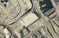
The Leverett Circle Connector Bridge is a 1.7 mile-long highway bridge over the Charles River in Boston, Massachusetts, carrying two lanes each of northbound and southbound traffic. It connects to Interstate 93 (I-93) at the northern end (exit 18, formerly 26 from I-93 south) and splits at the southern end, providing direct access to both Storrow Drive and Leverett Circle in Boston. Going northbound, there is also a fork which provides access to the City Square Tunnel under Charlestown to proceed on U.S. Route 1 (US 1) northbound via the Tobin Bridge.
Key Information


The span was built in conjunction with the more dramatic Leonard P. Zakim Bunker Hill Bridge as part of the Central Artery/Tunnel Project, widely known as the Big Dig. During construction, the Leverett Circle Connector Bridge was sometimes called "Baby Bridge".[2] The bridge opened for traffic on October 7, 1999,[3] at a cost of $22.27 million (equivalent to $39.3 million in 2024[4]).[5]
Also known as the Storrow Drive Connector, it is the largest steel box girder bridge in the United States. It was the winner of a July 2001 National Steel Bridge Alliance (NSBA) "prize bridge" award.[6] Its weaving design[further explanation needed] was determined by the other major structures involved in the Big Dig but unlike other parts of the project, it was finished eight days ahead of schedule.[5]
Major intersections
[edit]The entire route is in Boston, Suffolk County. All exits are unnumbered.
| Location | mi[1] | km | Destinations | Notes | |
|---|---|---|---|---|---|
| West End | 0.0 | 0.0 | At-grade intersection; North Station access via Nashua Street | ||
| 0.2 | 0.32 | Southbound exit and northbound entrance; no commercial vehicles | |||
| Charles River | 0.4– 0.5 | 0.64– 0.80 | Bridge | ||
| Charlestown | 0.7 | 1.1 | E-ZPass or pay-by-mail tolls on bridge; loop ramp via City Square Tunnel | ||
| 1.7 | 2.7 | Exit 18 on I-93; Somerville city line | |||
| 1.000 mi = 1.609 km; 1.000 km = 0.621 mi | |||||
Gallery
[edit]-
 Leverett Circle as seen behind North Station during Big Dig construction.
 -
 Part of the rebuilt connector bridge at right.


See also
[edit]References
[edit]- ^ a b "Leverett Circle Connector" (Map). Google Maps. Retrieved June 2, 2019.
- ^ Howe, Peter J. (August 10, 1998). "Masterpiece or monster". Boston Globe. p. C3.
- ^ "Leonard P Zakim-Bunker Hill Memorial Bridge (I-93 and US 1)". Boston Roads.[self-published source]
- ^ Johnston, Louis; Williamson, Samuel H. (2023). "What Was the U.S. GDP Then?". MeasuringWorth. Retrieved November 30, 2023. United States Gross Domestic Product deflator figures follow the MeasuringWorth series.
- ^ a b "MTA - the Charles River Bridges". Archived from the original on November 21, 2008. Retrieved December 5, 2008.
- ^ "National Steel Bridge Alliance 2001 Prize Bridge Award Winner: Medium Long Span Storrow Drive Connector Bridge". Modern Steel Construction. October 2001. Archived from the original on May 6, 2003. Retrieved January 15, 2022.