
Recent from talks
Tenzing-Hillary Airport
Knowledge base stats:
Talk channels stats:
Members stats:
Tenzing-Hillary Airport
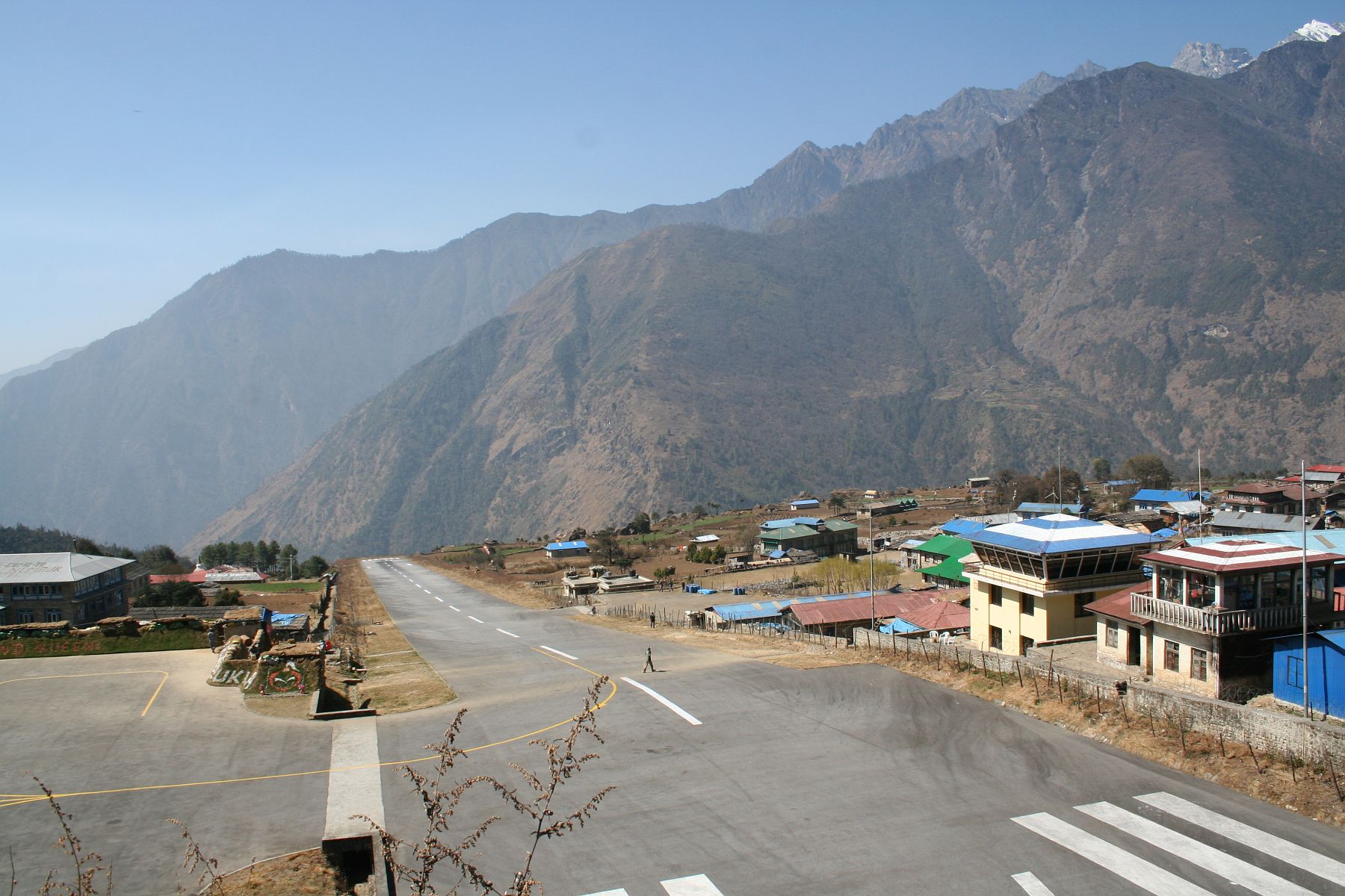
Tenzing-Hillary Airport (Nepali: तेन्जिङ हिलारी विमानस्थल, IATA: LUA, ICAO: VNLK), also known as Lukla Airport, is a domestic airport and altiport in the town of Lukla, in Khumbu Pasanglhamu, Solukhumbu District, Koshi Province of Nepal. The airport has gained worldwide fame, not only for its unusual location, but also because it was rated the most dangerous airport in the world for more than 20 years by a program titled Most Extreme Airports, broadcast on The History Channel in 2010.
The airport is popular because many people consider it the world's most dangerous airport. It has a starting point for treks towards Mount Everest Base Camp. There are daily flights between Ramechhap or Kathmandu and Lukla during daylight hours in good weather. Although the flying distances are short, rain often occurs in Lukla while the sun is shining in Ramechhap or Kathmandu. High winds, cloud cover, and changing visibility often mean flights can be delayed or the airport closed. The airport is contained within a chain-link fence and is patrolled by the Armed Police Force Nepal, Nepal Civil Police or Nepali Army around the clock for security.
Tenzing–Hillary Airport is officially named after the Nepalese mountaineer Tenzing Norgay and the New Zealand mountaineer Edmund Hillary, the first people to reach the summit of Mount Everest.
The airport was previously known simply as Lukla Airport. It received its current name after Prithvi Subba Gurung, Nepal's Minister of Culture, Tourism and Civil Aviation at the time, proposed the renaming on 14 January 2008. On 10 February 2008, following approval by the Koirala Interim Cabinet, Lukla Airport was officially renamed Tenzing–Hillary Airport in honor of the first two people to summit Mount Everest.
The airport was built in 1964 under the supervision of Edmund Hillary, who originally intended to build it on flat farmland. However, local farmers did not want to give up their land, so the airport was built in its current position. Hillary bought the land from local Sherpas for USD 2,650 and involved them in building the facilities. It has been said that Hillary was unhappy with the runway's soil resistance, and that his solution was to buy local liquor for the Sherpas and ask them to perform a foot-stomping dance to flatten the land that served as the runway. The runway was paved in 2001.
In January 2008, the airport was renamed in honour of Tenzing Norgay and Sir Edmund Hillary, the first people confirmed to have reached the summit of Mount Everest, and also to mark their efforts in the construction of this airport.
The airport's paved asphalt runway is accessible only to helicopters and small, fixed-wing, short-takeoff-and-landing aircraft such as the De Havilland Canada DHC-6 Twin Otter, Dornier 228, and Let L-410 Turbolet. The runway is 527 m (1,729 ft) × 30 m (98 ft) with an 11.7% gradient. The airport's elevation is 9,334 ft (2,845 m). The airport is used for passenger flights and for transporting most of the building materials and cargo to Lukla and other towns and villages to the north of Lukla, as there is no road to this region.
In the early morning, the wind is usually from the northeast, changing to a southwest wind from mid to late morning due to the action of the sun on the mountains to the north of Lukla. The airport regularly closes from mid to late morning due to the strong southwest winds that create crosswinds or tailwinds. Consequently, flights are usually scheduled for the early morning. A sudden loss of visibility preventing planes from landing under visual flight rules (VFR) will result in the immediate closure of the airport.
Hub AI
Tenzing-Hillary Airport AI simulator
(@Tenzing-Hillary Airport_simulator)
Tenzing-Hillary Airport
Tenzing-Hillary Airport (Nepali: तेन्जिङ हिलारी विमानस्थल, IATA: LUA, ICAO: VNLK), also known as Lukla Airport, is a domestic airport and altiport in the town of Lukla, in Khumbu Pasanglhamu, Solukhumbu District, Koshi Province of Nepal. The airport has gained worldwide fame, not only for its unusual location, but also because it was rated the most dangerous airport in the world for more than 20 years by a program titled Most Extreme Airports, broadcast on The History Channel in 2010.
The airport is popular because many people consider it the world's most dangerous airport. It has a starting point for treks towards Mount Everest Base Camp. There are daily flights between Ramechhap or Kathmandu and Lukla during daylight hours in good weather. Although the flying distances are short, rain often occurs in Lukla while the sun is shining in Ramechhap or Kathmandu. High winds, cloud cover, and changing visibility often mean flights can be delayed or the airport closed. The airport is contained within a chain-link fence and is patrolled by the Armed Police Force Nepal, Nepal Civil Police or Nepali Army around the clock for security.
Tenzing–Hillary Airport is officially named after the Nepalese mountaineer Tenzing Norgay and the New Zealand mountaineer Edmund Hillary, the first people to reach the summit of Mount Everest.
The airport was previously known simply as Lukla Airport. It received its current name after Prithvi Subba Gurung, Nepal's Minister of Culture, Tourism and Civil Aviation at the time, proposed the renaming on 14 January 2008. On 10 February 2008, following approval by the Koirala Interim Cabinet, Lukla Airport was officially renamed Tenzing–Hillary Airport in honor of the first two people to summit Mount Everest.
The airport was built in 1964 under the supervision of Edmund Hillary, who originally intended to build it on flat farmland. However, local farmers did not want to give up their land, so the airport was built in its current position. Hillary bought the land from local Sherpas for USD 2,650 and involved them in building the facilities. It has been said that Hillary was unhappy with the runway's soil resistance, and that his solution was to buy local liquor for the Sherpas and ask them to perform a foot-stomping dance to flatten the land that served as the runway. The runway was paved in 2001.
In January 2008, the airport was renamed in honour of Tenzing Norgay and Sir Edmund Hillary, the first people confirmed to have reached the summit of Mount Everest, and also to mark their efforts in the construction of this airport.
The airport's paved asphalt runway is accessible only to helicopters and small, fixed-wing, short-takeoff-and-landing aircraft such as the De Havilland Canada DHC-6 Twin Otter, Dornier 228, and Let L-410 Turbolet. The runway is 527 m (1,729 ft) × 30 m (98 ft) with an 11.7% gradient. The airport's elevation is 9,334 ft (2,845 m). The airport is used for passenger flights and for transporting most of the building materials and cargo to Lukla and other towns and villages to the north of Lukla, as there is no road to this region.
In the early morning, the wind is usually from the northeast, changing to a southwest wind from mid to late morning due to the action of the sun on the mountains to the north of Lukla. The airport regularly closes from mid to late morning due to the strong southwest winds that create crosswinds or tailwinds. Consequently, flights are usually scheduled for the early morning. A sudden loss of visibility preventing planes from landing under visual flight rules (VFR) will result in the immediate closure of the airport.
Recent media