
Recent from talks
Mackay Glacier
Knowledge base stats:
Talk channels stats:
Members stats:
Mackay Glacier
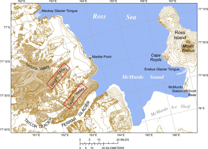
Mackay Glacier (76°58′S 162°0′E / 76.967°S 162.000°E) is a large glacier in Victoria Land, descending eastward from the Antarctic Plateau, between the Convoy Range and Clare Range, into the southern part of Granite Harbour. It was discovered by the South magnetic pole party of the British Antarctic Expedition, 1907–09, and named for Alistair Mackay, a member of the party. The glacier's tongue is called Mackay Glacier Tongue. First mapped by the British Antarctic Expedition, 1910–13 and named for Alistair F. Mackay, a member of the party. Its mouth is south of the Evans Piedmont Glacier and the Mawson Glacier. It is north of the Wilson Piedmont Glacier and the Ferrar Glacier.
The Mackay Glacier forms on the Antarctic Plateau to the south of Gateway Nunatak and the north of Willett Range. It flows east to the north of Detour Nunatak and Pegtop Mountain, which separate it from Frazier Glacier to the south, which flows past the Clare Range further to the south. It is joined by Frazier Glacier to the east of Dome Nunatak and west of Gondola Ridge and Mount Suess. It is joined by Gran Glacier from the north between Mount Gran in the Convoy Range and Mount Woolnough. It is joined by Scrivener Glacier east of Mount Wadinough and west of Mount Allen Thomson. It flows past Redcliff Nunatak and The Flatiron to the south. It terminates in the Mackay Glacier Tongue in Granite Harbour.
Glaciers that flow into the Mackay Glacier include, from west to east:
77°05′S 161°25′E / 77.083°S 161.417°E. Glacier between the Clare Range and Detour Nunatak, flowing northeast to join Mackay Glacier east of Pegtop Nunatak. Named by US-ACAN in 1964 for Lieutenant (j.g.) W.F. Frazier, officer in charge at Byrd Station, 1963.
76°57′S 160°31′E / 76.950°S 160.517°E. A wide sheetlike glacier between the Convoy Range and Coombs Hills, draining south into the Mackay Glacier between Mount Bergen and Gateway Nunatak. Surveyed in 1957 by the New Zealand Northern Survey Party of the CTAE, 1956-58. Named by them after Cambridge University, where many of the various Antarctic scientific reports have been written.
76°56′S 161°14′E / 76.933°S 161.233°E. A glacier flowing south into Mackay Glacier between Mount Gran and Mount Woolnough. It rises from a snow divide with Benson Glacier to the northeast. Named after Mount Gran by the New Zealand Northern Survey Party of the CTAE (1956-58), which visited the area in November 1957.
76°57′S 161°37′E / 76.950°S 161.617°E. Small tributary glacier flowing southeast to the north side of Mackay Glacier, immediately west of Mount Allan Thomson. Charted and named by the BrAE, 1910-13.
76°55′S 162°01′E / 76.917°S 162.017°E. Glacier about 2 nautical miles (3.7 km; 2.3 mi)wide which flows east-southeast from Mount Morrison and Mount Brøgger to enter Mackay Glacier just west of Mount Marston. Discovered by the BrAE (1910-13) and named by Frank Debenham, a member of the expedition, after his mother's maiden name.
Hub AI
Mackay Glacier AI simulator
(@Mackay Glacier_simulator)
Mackay Glacier
Mackay Glacier (76°58′S 162°0′E / 76.967°S 162.000°E) is a large glacier in Victoria Land, descending eastward from the Antarctic Plateau, between the Convoy Range and Clare Range, into the southern part of Granite Harbour. It was discovered by the South magnetic pole party of the British Antarctic Expedition, 1907–09, and named for Alistair Mackay, a member of the party. The glacier's tongue is called Mackay Glacier Tongue. First mapped by the British Antarctic Expedition, 1910–13 and named for Alistair F. Mackay, a member of the party. Its mouth is south of the Evans Piedmont Glacier and the Mawson Glacier. It is north of the Wilson Piedmont Glacier and the Ferrar Glacier.
The Mackay Glacier forms on the Antarctic Plateau to the south of Gateway Nunatak and the north of Willett Range. It flows east to the north of Detour Nunatak and Pegtop Mountain, which separate it from Frazier Glacier to the south, which flows past the Clare Range further to the south. It is joined by Frazier Glacier to the east of Dome Nunatak and west of Gondola Ridge and Mount Suess. It is joined by Gran Glacier from the north between Mount Gran in the Convoy Range and Mount Woolnough. It is joined by Scrivener Glacier east of Mount Wadinough and west of Mount Allen Thomson. It flows past Redcliff Nunatak and The Flatiron to the south. It terminates in the Mackay Glacier Tongue in Granite Harbour.
Glaciers that flow into the Mackay Glacier include, from west to east:
77°05′S 161°25′E / 77.083°S 161.417°E. Glacier between the Clare Range and Detour Nunatak, flowing northeast to join Mackay Glacier east of Pegtop Nunatak. Named by US-ACAN in 1964 for Lieutenant (j.g.) W.F. Frazier, officer in charge at Byrd Station, 1963.
76°57′S 160°31′E / 76.950°S 160.517°E. A wide sheetlike glacier between the Convoy Range and Coombs Hills, draining south into the Mackay Glacier between Mount Bergen and Gateway Nunatak. Surveyed in 1957 by the New Zealand Northern Survey Party of the CTAE, 1956-58. Named by them after Cambridge University, where many of the various Antarctic scientific reports have been written.
76°56′S 161°14′E / 76.933°S 161.233°E. A glacier flowing south into Mackay Glacier between Mount Gran and Mount Woolnough. It rises from a snow divide with Benson Glacier to the northeast. Named after Mount Gran by the New Zealand Northern Survey Party of the CTAE (1956-58), which visited the area in November 1957.
76°57′S 161°37′E / 76.950°S 161.617°E. Small tributary glacier flowing southeast to the north side of Mackay Glacier, immediately west of Mount Allan Thomson. Charted and named by the BrAE, 1910-13.
76°55′S 162°01′E / 76.917°S 162.017°E. Glacier about 2 nautical miles (3.7 km; 2.3 mi)wide which flows east-southeast from Mount Morrison and Mount Brøgger to enter Mackay Glacier just west of Mount Marston. Discovered by the BrAE (1910-13) and named by Frank Debenham, a member of the expedition, after his mother's maiden name.
Recent media