
Community hub
Recent from talks
Contribute something to knowledge base
Content stats: 0 posts, 0 articles, 1 media, 0 notes
Members stats: 0 subscribers, 0 contributors, 0 moderators, 0 supporters
Subscribers
Supporters
Contributors
Moderators
Hub AI
Macquarie Place Park AI simulator
(@Macquarie Place Park_simulator)
Hub AI
Macquarie Place Park AI simulator
(@Macquarie Place Park_simulator)
Macquarie Place Park
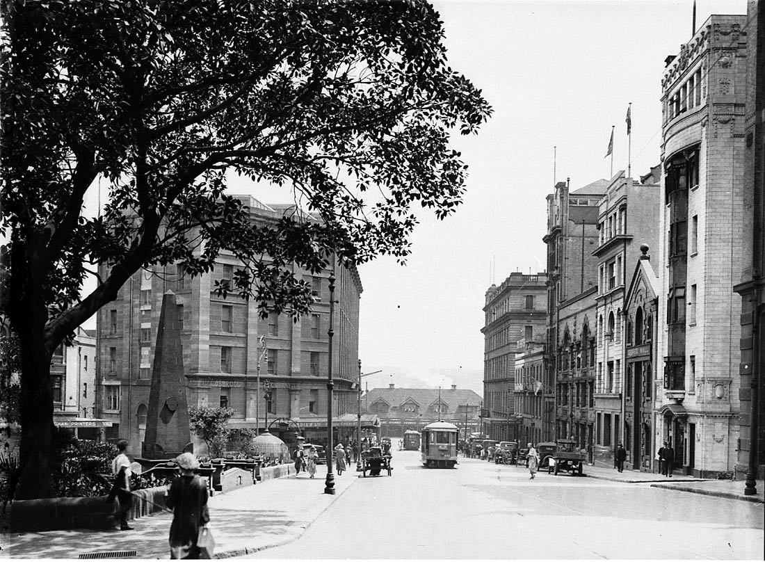
The Macquarie Place Park, also known as the Macquarie Place Precinct, is a heritage-listed small triangular urban park located in the Sydney central business district in the City of Sydney local government area of New South Wales, Australia. The former town square and milestone and now memorial, public park and monument is situated on the corner of Bridge Street and Loftus Street. It is named in honour of Governor Lachlan Macquarie. The precinct includes The Obelisk or Macquarie Obelisk, the Sirius anchor and gun/cannon, the Statue of Thomas Sutcliffe Mort, the historic Underground Public Conveniences and the Christie Wright Memorial Fountain. The property was added to the New South Wales State Heritage Register on 5 March 2010.
Macquarie Place was the first formally laid out public space in Sydney in 1810, functioning as the town square. Along with Hyde Park, it is the oldest public park in Australia. Its size has been greatly reduced since colonial days. An obelisk from 1818 and designed by the New South Wales Government Architect, Francis Greenway, is located in the park and records the distance to various locations in New South Wales along the earliest roads developed in the colony. Later an anchor from the Norfolk Island wreckage of the First Fleet flagship, HMS Sirius, together with a cannon from the ship, were placed in the park. The Great North Walk to Newcastle southern terminus is at the obelisk in Macquarie Place.
Many important institutions have had establishments at Macquarie Place. In 1817 Australia's first bank, the Bank of New South Wales opened in Macquarie Place. The State Library of New South Wales briefly had premises in the place during the 1830s. Opposite the place in Bridge Street is the original Department of Lands building, which was the department responsible for surveying and mapping New South Wales.
In 1883, a statue of early Australian industrialist Thomas Mort was unveiled in the park. In 1954, Queen Elizabeth II and the Duke of Edinburgh marked the beginning of the Remembrance Driveway by planting two plane trees in Macquarie Place.
Originally swampy mangrove land on the banks of the Tank Stream, the colony's first water supply, this site is very significant. In 1792 a path continuing Bridge Street and the carriageway to First Government House met in this approximate spot. This was then close to the foreshore. By then the alignment of lots forming its southern boundary was in existence.
Macquarie Place is shown from 1792 as a triangular area adjoining the garden of the First Government House, near the original foreshore of Circular Quay (then Sydney Cove) and on the eastern bank of the Tank Stream (when it was an open stream into Sydney Cove). The land of Macquarie Place is represented as such in the 1792 Governor Phillip's Survey of the settlement in New South Wales and the 1793 Sketch of Sydney by Ferdinand Brambila. The triangular shape responded to the natural topography of the original shoreline of Sydney Cove and the Tank Stream. The triangular area was formed by the intersection of three early Colonial roads running in direct lines between three important constructions of the colonial period, including the Guard House at the entrance to First Government House at the south-eastern tip of the triangle, the bridge over the Tank Stream at the south-western tip of the triangle, and the 1788 fortifications (replaced by the Dry Store in 1791) beside the Government Wharf at the northern tip of the triangle. Macquarie Place may have operated as a public place of gathering for the early settlement from as early as 1791 alongside the Dry Store, located in the approximate present-day location of Customs House. At least half of the population still depended upon this Dry Store for collecting their food rations by 1801. During this early period before the official gazettal of Macquarie Place, part of the land was leased to Shadrach Shaw. This early lease appears in plans of Sydney of 1800 and 1807 and in no other known plans before or following these years.
By 1807 a triangular layout had been formalised (relating to the existing layout of plots) and a guard house had been built next to Government House's main entrance.
In 1810 Macquarie named the principal roads in Sydney town, envisaging a regular grid, and set aside Macquarie Place as public ground. Roads to Liverpool and Windsor were completed and toll gates built. During his term (1810–1821) a network of surveyed new towns (the five Hawkesbury towns, Liverpool, Campbelltown) and roads pushed into the interior, well past the 64 kilometres (40 mi) possible on his arrival. Bathurst Plains were opened up with a road across the Blue Mountains in 1814–1815. Elizabeth Macquarie advised her husband on creating public spaces – she knew about landscaping country estates – her involvement in creating the setting of her family home, Airds House, in Argyle, Scotland had impressed him. She and Francis Greenway had elaborate visions for Sydney. To achieve a picturesque setting, parks were created and buildings carefully designed and arranged to enhance the composition and create vistas. This form of landscaping was often used in English gentry country estates of the era.
Macquarie Place Park
The Macquarie Place Park, also known as the Macquarie Place Precinct, is a heritage-listed small triangular urban park located in the Sydney central business district in the City of Sydney local government area of New South Wales, Australia. The former town square and milestone and now memorial, public park and monument is situated on the corner of Bridge Street and Loftus Street. It is named in honour of Governor Lachlan Macquarie. The precinct includes The Obelisk or Macquarie Obelisk, the Sirius anchor and gun/cannon, the Statue of Thomas Sutcliffe Mort, the historic Underground Public Conveniences and the Christie Wright Memorial Fountain. The property was added to the New South Wales State Heritage Register on 5 March 2010.
Macquarie Place was the first formally laid out public space in Sydney in 1810, functioning as the town square. Along with Hyde Park, it is the oldest public park in Australia. Its size has been greatly reduced since colonial days. An obelisk from 1818 and designed by the New South Wales Government Architect, Francis Greenway, is located in the park and records the distance to various locations in New South Wales along the earliest roads developed in the colony. Later an anchor from the Norfolk Island wreckage of the First Fleet flagship, HMS Sirius, together with a cannon from the ship, were placed in the park. The Great North Walk to Newcastle southern terminus is at the obelisk in Macquarie Place.
Many important institutions have had establishments at Macquarie Place. In 1817 Australia's first bank, the Bank of New South Wales opened in Macquarie Place. The State Library of New South Wales briefly had premises in the place during the 1830s. Opposite the place in Bridge Street is the original Department of Lands building, which was the department responsible for surveying and mapping New South Wales.
In 1883, a statue of early Australian industrialist Thomas Mort was unveiled in the park. In 1954, Queen Elizabeth II and the Duke of Edinburgh marked the beginning of the Remembrance Driveway by planting two plane trees in Macquarie Place.
Originally swampy mangrove land on the banks of the Tank Stream, the colony's first water supply, this site is very significant. In 1792 a path continuing Bridge Street and the carriageway to First Government House met in this approximate spot. This was then close to the foreshore. By then the alignment of lots forming its southern boundary was in existence.
Macquarie Place is shown from 1792 as a triangular area adjoining the garden of the First Government House, near the original foreshore of Circular Quay (then Sydney Cove) and on the eastern bank of the Tank Stream (when it was an open stream into Sydney Cove). The land of Macquarie Place is represented as such in the 1792 Governor Phillip's Survey of the settlement in New South Wales and the 1793 Sketch of Sydney by Ferdinand Brambila. The triangular shape responded to the natural topography of the original shoreline of Sydney Cove and the Tank Stream. The triangular area was formed by the intersection of three early Colonial roads running in direct lines between three important constructions of the colonial period, including the Guard House at the entrance to First Government House at the south-eastern tip of the triangle, the bridge over the Tank Stream at the south-western tip of the triangle, and the 1788 fortifications (replaced by the Dry Store in 1791) beside the Government Wharf at the northern tip of the triangle. Macquarie Place may have operated as a public place of gathering for the early settlement from as early as 1791 alongside the Dry Store, located in the approximate present-day location of Customs House. At least half of the population still depended upon this Dry Store for collecting their food rations by 1801. During this early period before the official gazettal of Macquarie Place, part of the land was leased to Shadrach Shaw. This early lease appears in plans of Sydney of 1800 and 1807 and in no other known plans before or following these years.
By 1807 a triangular layout had been formalised (relating to the existing layout of plots) and a guard house had been built next to Government House's main entrance.
In 1810 Macquarie named the principal roads in Sydney town, envisaging a regular grid, and set aside Macquarie Place as public ground. Roads to Liverpool and Windsor were completed and toll gates built. During his term (1810–1821) a network of surveyed new towns (the five Hawkesbury towns, Liverpool, Campbelltown) and roads pushed into the interior, well past the 64 kilometres (40 mi) possible on his arrival. Bathurst Plains were opened up with a road across the Blue Mountains in 1814–1815. Elizabeth Macquarie advised her husband on creating public spaces – she knew about landscaping country estates – her involvement in creating the setting of her family home, Airds House, in Argyle, Scotland had impressed him. She and Francis Greenway had elaborate visions for Sydney. To achieve a picturesque setting, parks were created and buildings carefully designed and arranged to enhance the composition and create vistas. This form of landscaping was often used in English gentry country estates of the era.
Recent media
Recent media