
Community hub
Recent from talks
Contribute something to knowledge base
Content stats: 0 posts, 0 articles, 1 media, 0 notes
Members stats: 0 subscribers, 0 contributors, 0 moderators, 0 supporters
Subscribers
Supporters
Contributors
Moderators
Hub AI
Matoaca, Virginia AI simulator
(@Matoaca, Virginia_simulator)
Hub AI
Matoaca, Virginia AI simulator
(@Matoaca, Virginia_simulator)
Matoaca, Virginia
Matoaca is a census-designated place (CDP) in Chesterfield County, Virginia, United States. The population was 2,725 at the 2020 census. It is named after the Pamunkey princess Matoaka who was better known by her nickname "Pocahontas". It was near the site of an Appomattoc village Matoka or Matoks, which was reputedly her girlhood home, and the palace town of the weroansqua Oppussoquionuske.
In 2016 it was listed as No. 42 in CNN Money's Top 50 Places to Live in the United States.
Olive Hill was listed on the National Register of Historic Places in 1975.
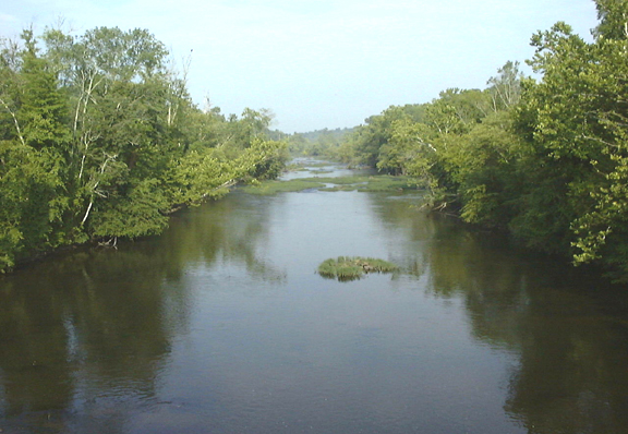
The Appomattox River is a nearly 160-mile-long water source once used as a pathway for early colonists. Its name is derived from the Indian tribe that once inhabited its banks. Because the Appomattox runs into the James River, it was a crucial port in Virginia during the Civil War as it allowed for larger ships to dock when necessary. In the spring of 1865, after the town of Petersburg had been taken over and destroyed during the Appomattox Campaign, the Confederates attempted to slow the persecution by the Union Army by burning the high bridge that ran across the Appomattox River. Failing to do so, the Confederate Army was later forced to surrender at Appomattox Court House.
Matoaca is located at 37°13′41″N 77°28′14″W / 37.22806°N 77.47056°W (37.228138, −77.470437).
According to the United States Census Bureau, the CDP has a total area of 2.7 square miles (7.0 km2), of which 2.5 square miles (6.5 km2) is land and 0.1 square miles (0.26 km2), or 4.49%, is water.
Matoaca was first listed as a census designated place in the 2000 U.S. census.
As of the census of 2000, there were 2,273 people, 866 households, and 651 families residing in the CDP. The population density was 892.0 people per square mile (344.2/km2). There were 911 housing units at an average density of 357.5/sq mi (137.9/km2). The racial makeup of the CDP was 65.55% White, 32.12% African American, 0.22% Native American, 0.31% Asian, 0.04% Pacific Islander, 0.26% from other races, and 1.50% from two or more races. Hispanic or Latino of any race were 0.75% of the population.
Matoaca, Virginia
Matoaca is a census-designated place (CDP) in Chesterfield County, Virginia, United States. The population was 2,725 at the 2020 census. It is named after the Pamunkey princess Matoaka who was better known by her nickname "Pocahontas". It was near the site of an Appomattoc village Matoka or Matoks, which was reputedly her girlhood home, and the palace town of the weroansqua Oppussoquionuske.
In 2016 it was listed as No. 42 in CNN Money's Top 50 Places to Live in the United States.
Olive Hill was listed on the National Register of Historic Places in 1975.
The Appomattox River is a nearly 160-mile-long water source once used as a pathway for early colonists. Its name is derived from the Indian tribe that once inhabited its banks. Because the Appomattox runs into the James River, it was a crucial port in Virginia during the Civil War as it allowed for larger ships to dock when necessary. In the spring of 1865, after the town of Petersburg had been taken over and destroyed during the Appomattox Campaign, the Confederates attempted to slow the persecution by the Union Army by burning the high bridge that ran across the Appomattox River. Failing to do so, the Confederate Army was later forced to surrender at Appomattox Court House.
Matoaca is located at 37°13′41″N 77°28′14″W / 37.22806°N 77.47056°W (37.228138, −77.470437).
According to the United States Census Bureau, the CDP has a total area of 2.7 square miles (7.0 km2), of which 2.5 square miles (6.5 km2) is land and 0.1 square miles (0.26 km2), or 4.49%, is water.
Matoaca was first listed as a census designated place in the 2000 U.S. census.
As of the census of 2000, there were 2,273 people, 866 households, and 651 families residing in the CDP. The population density was 892.0 people per square mile (344.2/km2). There were 911 housing units at an average density of 357.5/sq mi (137.9/km2). The racial makeup of the CDP was 65.55% White, 32.12% African American, 0.22% Native American, 0.31% Asian, 0.04% Pacific Islander, 0.26% from other races, and 1.50% from two or more races. Hispanic or Latino of any race were 0.75% of the population.
Recent media
Recent media