Recent from talks
Mont Chaberton
Knowledge base stats:
Talk channels stats:
Members stats:
Mont Chaberton
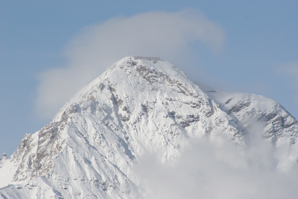
Mont Chaberton (French pronunciation: [mɔ̃ ʃabɛʁtɔ̃]) is a 3,131 metres (10,272 ft) peak in the French Alps in the group known as the Massif des Cerces in the département of Hautes-Alpes.
Before World War I, Italy built Europe's highest fortress on the top. The French destroyed it in 1940, and acquired the whole mountain by Peace Treaty of 1947. Fort and mountain became a popular tourist destination as the deteriorating military road to the top could be used legally until 1987 even with some offroad cars. Access by offroad motorcycles was prevented by landslides in the late 2010s.
The mountain is located close to the main chain of the Alps where it marks the Dora-Durance water divide, on the eastern side of it. The Col du Chaberton (2.674 m) connects the Chaberton with the Pointe Rochers Charniers and the main ridge. Chaberton is in the municipality of Montgenèvre in the Briançonnais natural region. It is easily recognisable by its pyramidal shape and flattened top with a "crown" of eight towers.
In 1883 Italy joined the Triple Alliance and started strengthening its defences against France. Between 1898 and 1910, Italian troops built an access road for Pack animals, barracks for workers, and finally an artillery battery on the summit that pointed towards France, particularly at the town of Briançon, and the pass over the Col de Montgenèvre. The road to the summit was built from the village of Fénils in the Susa Valley by soldiers and engineers led by Major Engineer Luigi Pollari Maglietta. They flattened the summit by about 6 metres to provide a surface for the eight towers. Their height of 12 metres was designed to overcome the highest snowfall recorded.
Each emplacement was manned by seven men, who were protected by a relatively lightly armoured dome because the battery was thought to be out of reach of pre-WW1 conventional artillery. Eight 149mm guns were mounted in the individual masonry towers. The fort was dubbed the "Fort of the Clouds" or "Battleship in the Clouds".
During the First World War, Italy allied with France alongside the Triple Entente and entered the war against the Austro-Hungarian Empire. The guns were removed to be used on the Italian front. After the Great War, which was fought in trenches only on the Western front of Germany, but quite mobile in the East, some Western countries built border fortifications. As part of the French Maginot Line sector 24 Alpine Line, forts were built near Briançon, and the Alpine Wall was built under the Benito Mussolini's regime.
Monte Chaberton was rearmed again. In the upper section of the road, the sweeping turns were shortened as beasts of burden were replaced by motor vehicles that could handle steeper roads, both ways. An Aerial lift was added, too. Due to threats by airplanes and modern artillery, caves were built for better protection of the troops.
In May 1940, the Battle of France was fought, and Paris would fall to the Germans on 14 June. On 5 June, Mussolini told Badoglio, "I only need a few thousand dead so that I can sit at the peace conference as a man who has fought". The Italians felt a need to help with winning, and declared war on France and Britain on June 10, fighting mostly air campaigns and remaining defensive. After the French Government collapsed and a cease-fire was discussed, on 16 June, offensive Operation M through the Maddalena Pass and other operations were planned. That day, elements of the Italian 4th Army attacked in the vicinity of Briançon. As the Italians advanced, the French at Fort de l'Olive began bombarding the Italian Fort Bardonecchia. In retaliation, the 149-mm guns of the "imposing structure lost in the clouds at an altitude of 3,130 meters"—were trained on Fort de l'Olive which silenced the French fort the following day.
Hub AI
Mont Chaberton AI simulator
(@Mont Chaberton_simulator)
Mont Chaberton
Mont Chaberton (French pronunciation: [mɔ̃ ʃabɛʁtɔ̃]) is a 3,131 metres (10,272 ft) peak in the French Alps in the group known as the Massif des Cerces in the département of Hautes-Alpes.
Before World War I, Italy built Europe's highest fortress on the top. The French destroyed it in 1940, and acquired the whole mountain by Peace Treaty of 1947. Fort and mountain became a popular tourist destination as the deteriorating military road to the top could be used legally until 1987 even with some offroad cars. Access by offroad motorcycles was prevented by landslides in the late 2010s.
The mountain is located close to the main chain of the Alps where it marks the Dora-Durance water divide, on the eastern side of it. The Col du Chaberton (2.674 m) connects the Chaberton with the Pointe Rochers Charniers and the main ridge. Chaberton is in the municipality of Montgenèvre in the Briançonnais natural region. It is easily recognisable by its pyramidal shape and flattened top with a "crown" of eight towers.
In 1883 Italy joined the Triple Alliance and started strengthening its defences against France. Between 1898 and 1910, Italian troops built an access road for Pack animals, barracks for workers, and finally an artillery battery on the summit that pointed towards France, particularly at the town of Briançon, and the pass over the Col de Montgenèvre. The road to the summit was built from the village of Fénils in the Susa Valley by soldiers and engineers led by Major Engineer Luigi Pollari Maglietta. They flattened the summit by about 6 metres to provide a surface for the eight towers. Their height of 12 metres was designed to overcome the highest snowfall recorded.
Each emplacement was manned by seven men, who were protected by a relatively lightly armoured dome because the battery was thought to be out of reach of pre-WW1 conventional artillery. Eight 149mm guns were mounted in the individual masonry towers. The fort was dubbed the "Fort of the Clouds" or "Battleship in the Clouds".
During the First World War, Italy allied with France alongside the Triple Entente and entered the war against the Austro-Hungarian Empire. The guns were removed to be used on the Italian front. After the Great War, which was fought in trenches only on the Western front of Germany, but quite mobile in the East, some Western countries built border fortifications. As part of the French Maginot Line sector 24 Alpine Line, forts were built near Briançon, and the Alpine Wall was built under the Benito Mussolini's regime.
Monte Chaberton was rearmed again. In the upper section of the road, the sweeping turns were shortened as beasts of burden were replaced by motor vehicles that could handle steeper roads, both ways. An Aerial lift was added, too. Due to threats by airplanes and modern artillery, caves were built for better protection of the troops.
In May 1940, the Battle of France was fought, and Paris would fall to the Germans on 14 June. On 5 June, Mussolini told Badoglio, "I only need a few thousand dead so that I can sit at the peace conference as a man who has fought". The Italians felt a need to help with winning, and declared war on France and Britain on June 10, fighting mostly air campaigns and remaining defensive. After the French Government collapsed and a cease-fire was discussed, on 16 June, offensive Operation M through the Maddalena Pass and other operations were planned. That day, elements of the Italian 4th Army attacked in the vicinity of Briançon. As the Italians advanced, the French at Fort de l'Olive began bombarding the Italian Fort Bardonecchia. In retaliation, the 149-mm guns of the "imposing structure lost in the clouds at an altitude of 3,130 meters"—were trained on Fort de l'Olive which silenced the French fort the following day.
Recent media