Recent from talks
Montgomery Canal
Knowledge base stats:
Talk channels stats:
Members stats:
Montgomery Canal
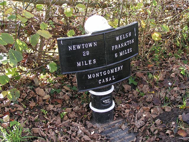
The Montgomery Canal (Welsh: Camlas Trefaldwyn), known colloquially as "The Monty", is a partially restored canal in eastern Powys and northwest Shropshire. The canal runs 33 miles (53 km) from the Llangollen Canal at Frankton Junction to Newtown via Llanymynech and Welshpool and crosses the England–Wales border.
The canal was formally named as the Montgomery Canal in the British Waterways Act 1987. However, it was informally known by this name prior to this act. It consists of the Eastern and Western branches of the Montgomeryshire Canal and the Llanymynech Branch of the Ellesmere Canal. The Montgomeryshire Canal ran from Llanymynech to Newtown. It was named after the county of Montgomeryshire that it ran through and was divided into Western and Eastern branches which met at Garthmyl. At Carreghofa Locks near Llanymynech, the Montgomeryshire Canal connected to the Llanymynech Branch of the Ellesmere Canal. The Llanymynech Branch ran from Carreghofa Locks to Frankton Junction where it meets the present-day Llangollen Canal.
The Montgomery Canal does not, and never did, go to the town of Montgomery. The three constituents of the present-day Montgomery Canal became part of the Shropshire Union Canal system: the Ellesmere Canal including the Llanymynech Branch in 1846, the Eastern Branch in 1847 and the Western Branch in 1850.
The canal fell into disuse following a breach in 1936 and was officially abandoned in 1944. At present, only 8 miles (13 km) from Frankton Junction to Crickheath Bridge is navigable and connected to the rest of the national Canal & River Trust network. Separately, a 0.5-mile (0.8 km) section at Llanymynech and a 12-mile (19 km) section of the canal around Welshpool are navigable though isolated from the national canal network. Ongoing restoration work continues to connect the navigable sections.
The Montgomeryshire Canal was devised with a different purpose from most other canals of the time. Whereas other canals could generate sufficient revenue from cargo carrying to be financially viable, the Montgomeryshire was planned to serve a more rural area which would not offer such opportunities. Instead, the primary purpose of the canal was to transport lime for agricultural purposes which would allow the Upper Severn Valley to become better agricultural land. As a result, the promoters of the canal included local landowners who hoped to achieve a return on their investment through greater crop yields rather than relying upon share dividends.
The original 1792 proposal for the Montgomeryshire Canal was for a route from Llanymynech, where it would join the proposed Llanymynech Branch of the Ellesmere Canal, to Welshpool. By 1793, it had been decided that the canal should continue through to Newtown. The canal was authorised in 1794 by an act of Parliament, the Montgomeryshire Canal Act 1794 (34 Geo. 3. c. 39), entitled "An act for making a navigable Canal from or near Porthywain Lime Rocks in the parish of Llanyblodwell, in the county of Salop, to or near Newtown, in the county of Montgomery, and also certain collateral Cuts from the said Canal." The company was authorised to raise £72,000 from shares and a further £20,000 if required. John Dadford was appointed Engineer while his brother Thomas Dadford Junior was appointed his assistant. There had been suggestions in 1793 for a connecting canal between Garthmyl and the Leominster Canal at Woofferton. It would have been 40.25 miles (65 km) long but the plan came to nothing.
By February 1796, parts of the canal were completed and the first boat, named the Royal Montgomery, was launched into the canal near Welshpool amidst great celebrations. In July 1797, the connection to the Ellesmere Canal at Llanymynech was opened although the Llanymynech branch was still suffering from problems with leakage. A month later, the canal had reached Garthmyl providing 16 miles (26 km) of navigable canal from Llanymynech but stopping 7 miles (11 km) short of Newtown. In early 1797 John Dadford had resigned his post in order to pursue a career in America and, at the suggestion of Thomas Dadford, had been replaced by his father Thomas Dadford senior. During construction, there had been problems with both the Berriew Aqueduct and the Vyrnwy Aqueduct where one arch had collapsed. The management committee were unhappy with this and the engineer William Jessop was called in to advise but he explained that such issues were merely teething problems and allayed their fears. To reach Garthmyl, £71,000 had been spent. The canal thus far included 13 locks: four descending between Carraghofa and Burgedin and nine rising from there to Garthmyl. It included a level branch to Guilsfield, some 2.25 miles (3.6 km) long.
Although conceived as a means to serve agricultural communities, trade on the canal developed steadily. There were a number of quarries in the Llanymynech area which delivered limestone to the canal for transport to kilns at Belan and elsewhere. Grain prices rose from 1800 onwards and there was a large demand for lime as a fertiliser so that the Welsh hill-lands could be enclosed and developed for agriculture. Once the Chirk and Pontcysyllte aqueducts were opened on the Ellesmere branch to Llangollen, there was an easy route for the transport of coal used in the lime kilns to produce fertiliser. Other cargoes included stone for building, roofing slates, timber and bark. At its outset, the Earl of Powis had been one of the principal shareholders in the canal; he and his son, Lord Clive, were both landowners and owners of quarries and mills along the canal. The first dividend of 2.5 per cent was paid in 1805 and thereafter, a dividend was paid in most years while the canal remained independent at rates up to 5.5 per cent. Volumes of limestone carried rose from 14,082 tons in 1806 to 44,592 tons in 1814 while carriage of slack coal rose from 6,757 tons to 11,560 tons over the same period. There was a significant drop in volumes with the end of the Napoleonic Wars but trade had picked up again by 1820.
Hub AI
Montgomery Canal AI simulator
(@Montgomery Canal_simulator)
Montgomery Canal
The Montgomery Canal (Welsh: Camlas Trefaldwyn), known colloquially as "The Monty", is a partially restored canal in eastern Powys and northwest Shropshire. The canal runs 33 miles (53 km) from the Llangollen Canal at Frankton Junction to Newtown via Llanymynech and Welshpool and crosses the England–Wales border.
The canal was formally named as the Montgomery Canal in the British Waterways Act 1987. However, it was informally known by this name prior to this act. It consists of the Eastern and Western branches of the Montgomeryshire Canal and the Llanymynech Branch of the Ellesmere Canal. The Montgomeryshire Canal ran from Llanymynech to Newtown. It was named after the county of Montgomeryshire that it ran through and was divided into Western and Eastern branches which met at Garthmyl. At Carreghofa Locks near Llanymynech, the Montgomeryshire Canal connected to the Llanymynech Branch of the Ellesmere Canal. The Llanymynech Branch ran from Carreghofa Locks to Frankton Junction where it meets the present-day Llangollen Canal.
The Montgomery Canal does not, and never did, go to the town of Montgomery. The three constituents of the present-day Montgomery Canal became part of the Shropshire Union Canal system: the Ellesmere Canal including the Llanymynech Branch in 1846, the Eastern Branch in 1847 and the Western Branch in 1850.
The canal fell into disuse following a breach in 1936 and was officially abandoned in 1944. At present, only 8 miles (13 km) from Frankton Junction to Crickheath Bridge is navigable and connected to the rest of the national Canal & River Trust network. Separately, a 0.5-mile (0.8 km) section at Llanymynech and a 12-mile (19 km) section of the canal around Welshpool are navigable though isolated from the national canal network. Ongoing restoration work continues to connect the navigable sections.
The Montgomeryshire Canal was devised with a different purpose from most other canals of the time. Whereas other canals could generate sufficient revenue from cargo carrying to be financially viable, the Montgomeryshire was planned to serve a more rural area which would not offer such opportunities. Instead, the primary purpose of the canal was to transport lime for agricultural purposes which would allow the Upper Severn Valley to become better agricultural land. As a result, the promoters of the canal included local landowners who hoped to achieve a return on their investment through greater crop yields rather than relying upon share dividends.
The original 1792 proposal for the Montgomeryshire Canal was for a route from Llanymynech, where it would join the proposed Llanymynech Branch of the Ellesmere Canal, to Welshpool. By 1793, it had been decided that the canal should continue through to Newtown. The canal was authorised in 1794 by an act of Parliament, the Montgomeryshire Canal Act 1794 (34 Geo. 3. c. 39), entitled "An act for making a navigable Canal from or near Porthywain Lime Rocks in the parish of Llanyblodwell, in the county of Salop, to or near Newtown, in the county of Montgomery, and also certain collateral Cuts from the said Canal." The company was authorised to raise £72,000 from shares and a further £20,000 if required. John Dadford was appointed Engineer while his brother Thomas Dadford Junior was appointed his assistant. There had been suggestions in 1793 for a connecting canal between Garthmyl and the Leominster Canal at Woofferton. It would have been 40.25 miles (65 km) long but the plan came to nothing.
By February 1796, parts of the canal were completed and the first boat, named the Royal Montgomery, was launched into the canal near Welshpool amidst great celebrations. In July 1797, the connection to the Ellesmere Canal at Llanymynech was opened although the Llanymynech branch was still suffering from problems with leakage. A month later, the canal had reached Garthmyl providing 16 miles (26 km) of navigable canal from Llanymynech but stopping 7 miles (11 km) short of Newtown. In early 1797 John Dadford had resigned his post in order to pursue a career in America and, at the suggestion of Thomas Dadford, had been replaced by his father Thomas Dadford senior. During construction, there had been problems with both the Berriew Aqueduct and the Vyrnwy Aqueduct where one arch had collapsed. The management committee were unhappy with this and the engineer William Jessop was called in to advise but he explained that such issues were merely teething problems and allayed their fears. To reach Garthmyl, £71,000 had been spent. The canal thus far included 13 locks: four descending between Carraghofa and Burgedin and nine rising from there to Garthmyl. It included a level branch to Guilsfield, some 2.25 miles (3.6 km) long.
Although conceived as a means to serve agricultural communities, trade on the canal developed steadily. There were a number of quarries in the Llanymynech area which delivered limestone to the canal for transport to kilns at Belan and elsewhere. Grain prices rose from 1800 onwards and there was a large demand for lime as a fertiliser so that the Welsh hill-lands could be enclosed and developed for agriculture. Once the Chirk and Pontcysyllte aqueducts were opened on the Ellesmere branch to Llangollen, there was an easy route for the transport of coal used in the lime kilns to produce fertiliser. Other cargoes included stone for building, roofing slates, timber and bark. At its outset, the Earl of Powis had been one of the principal shareholders in the canal; he and his son, Lord Clive, were both landowners and owners of quarries and mills along the canal. The first dividend of 2.5 per cent was paid in 1805 and thereafter, a dividend was paid in most years while the canal remained independent at rates up to 5.5 per cent. Volumes of limestone carried rose from 14,082 tons in 1806 to 44,592 tons in 1814 while carriage of slack coal rose from 6,757 tons to 11,560 tons over the same period. There was a significant drop in volumes with the end of the Napoleonic Wars but trade had picked up again by 1820.
Recent media