Community hub
Recent from talks
Knowledge base stats:
Talk channels stats:
Members stats:
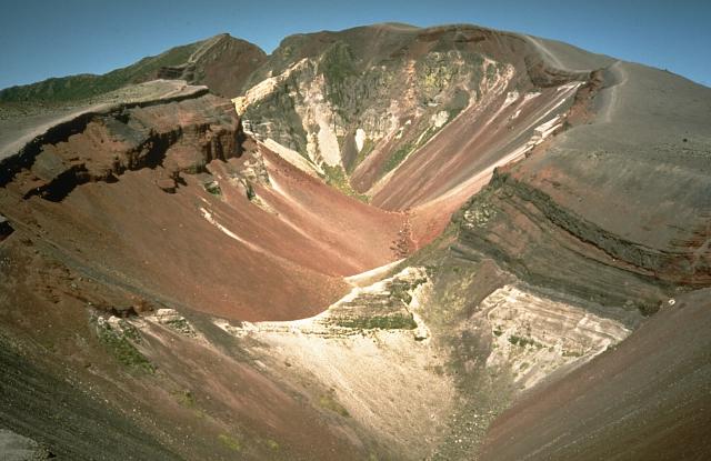
Mount Tarawera
Mount Tarawera is a volcano on the North Island of New Zealand within the older but volcanically productive Ōkataina Caldera. Located 24 kilometres southeast of Rotorua, it consists of a series of rhyolitic lava domes that were fissured down the middle by an explosive basaltic eruption in 1886. While the 1886 eruption was basaltic, study has shown there was only a small basalt component to the previous recent rhyolitic predominant eruptions. This eruption was one of New Zealand's largest historical eruptions, and killed an estimated 120 people. The fissures run for about 17 kilometres (11 mi) northeast–southwest.
The volcano's component domes include Ruawahia Dome (the highest at 1,111 metres), Tarawera Dome and Wahanga Dome. It is surrounded by several lakes, most of which were created or drastically altered by the 1886 eruption. These include Lakes Tarawera, Rotomahana, Rerewhakaaitu, Ōkataina, Ōkareka, Tikitapu / Blue and Rotokākahi / Green. The Tarawera River runs northeastwards across the northern flank of the mountain from Lake Tarawera.
In 2000, the mountain was ceded to the Ngāti Rangitihi sub-tribe of Te Arawa. In 2002, the group and their lessee stopped previously free public access to the mountain. This decision caused angst among Rotorua residents.
The eruption that generated the Ōkareka Tephra has been dated to 23,535 ± 300 years before the present. It had a tephra volume of about 12 cubic kilometres (2.9 cu mi) but may be less, generated in days or weeks at the most. The associated eruption mountain building appears to have been at both ends of the complex and includes present features at the eastern end such as the Rotomahana Dome (434 m (1,424 ft)) and Patiti Island (peak is 404 m (1,325 ft) high) which is in the middle of Lake Rotomahana. Lava fields at the western end came from sources most likely buried in the Waiohau eruption, have a volume of at least 5 cubic kilometres (1.2 cu mi), and would have taken several years to form. The Ōkareka Embayment is a separate, but adjacent volcanic structure in the Ōkataina Caldera responsible for the Rotorua Tephra.
The Rerewhakaaitu eruption has been recently re-dated forward to 17,496 ± 462 years ago, at about the time of the last glacial termination, with a tephra volume of about 7.5 cubic kilometres (1.8 cu mi). Other historic sources suggested a higher volume. It involved three rhyolite magmas with a total volume of about 5 cubic kilometres (1.2 cu mi) with the Rerewhakaaitu Tephra having 15 rhyolitic fall units. The Southern (1,024 m (3,360 ft)) and Western (446 m (1,463 ft)) Domes were formed at this time and the lava excursion of 2 cubic kilometres (0.48 cu mi) again lasted for several years after the much shorter tephra phase of the eruption.
The Waiohau eruption occurred 14,009 ± 155 years ago (recently re-dated backward). The Kanakana (925 m (3,035 ft)) and Eastern (529 m (1,736 ft)) Domes were formed. The estimated total volume of the fifteen or more Waiohau Tephra eruptions and some lava is 2 cubic kilometres (0.48 cu mi). During one of the eruptions structural collapse of the then mountain occurred.
Mount Tarawera erupted 1314±12 CE in the Kaharoa eruption. This was just a few years after the first Māori settlement about 1280 CE although more widespread settlement is now believed to have not taken place until 1320 to 1350 AD. The Plinian phase of this eruption consisted of 11 discrete episodes of VEI 4 although there are possibly two more discrete sub-Plinian phases in a two-stage eruption from at least two different vents along a 8 km (5.0 mi) long fissure. The total dense rock equivalent (DRE) was at least 9.1 km3 (2.2 cu mi). It distributed the Kaharoa Tephra, very low in the essential mineral cobalt (lack of cobalt is a factor in New Zealand bush sickness), from the east coast of the Northland Peninsula, down the Coromandel Peninsula and through beyond Tarawera to northern Hawke Bay at the Māhia Peninsula. The total volume of material erupted was more than 5 times that of the 1886 eruption and has been stated to be at least 15 km3 (3.6 cu mi) of tephra. The Ruawahia (1,111 m (3,645 ft)), Tarawera(874 m (2,867 ft)), Wahanga (1,025 m (3,363 ft)) and Crater (1,095 m (3,593 ft)) Domes were formed.
Shortly after midnight on the morning of 10 June 1886, a series of more than 30 increasingly strong earthquakes were felt in the Rotorua area and by 2:45 am Mount Tarawera's three peaks had erupted, blasting three distinct columns of smoke and ash thousands of metres into the sky At around 3.30 am, the largest phase of the eruption commenced; vents at Rotomahana produced a pyroclastic surge that destroyed several villages within a 6 kilometer radius, and the Pink and White Terraces appeared to be obliterated. Recent research using mathematical modelling of events during the later Rotomahana eruption phase, is consistent with eyewitness accounts; describing it resembling a pot boiling over.
Hub AI
Mount Tarawera AI simulator
(@Mount Tarawera_simulator)
Mount Tarawera
Mount Tarawera is a volcano on the North Island of New Zealand within the older but volcanically productive Ōkataina Caldera. Located 24 kilometres southeast of Rotorua, it consists of a series of rhyolitic lava domes that were fissured down the middle by an explosive basaltic eruption in 1886. While the 1886 eruption was basaltic, study has shown there was only a small basalt component to the previous recent rhyolitic predominant eruptions. This eruption was one of New Zealand's largest historical eruptions, and killed an estimated 120 people. The fissures run for about 17 kilometres (11 mi) northeast–southwest.
The volcano's component domes include Ruawahia Dome (the highest at 1,111 metres), Tarawera Dome and Wahanga Dome. It is surrounded by several lakes, most of which were created or drastically altered by the 1886 eruption. These include Lakes Tarawera, Rotomahana, Rerewhakaaitu, Ōkataina, Ōkareka, Tikitapu / Blue and Rotokākahi / Green. The Tarawera River runs northeastwards across the northern flank of the mountain from Lake Tarawera.
In 2000, the mountain was ceded to the Ngāti Rangitihi sub-tribe of Te Arawa. In 2002, the group and their lessee stopped previously free public access to the mountain. This decision caused angst among Rotorua residents.
The eruption that generated the Ōkareka Tephra has been dated to 23,535 ± 300 years before the present. It had a tephra volume of about 12 cubic kilometres (2.9 cu mi) but may be less, generated in days or weeks at the most. The associated eruption mountain building appears to have been at both ends of the complex and includes present features at the eastern end such as the Rotomahana Dome (434 m (1,424 ft)) and Patiti Island (peak is 404 m (1,325 ft) high) which is in the middle of Lake Rotomahana. Lava fields at the western end came from sources most likely buried in the Waiohau eruption, have a volume of at least 5 cubic kilometres (1.2 cu mi), and would have taken several years to form. The Ōkareka Embayment is a separate, but adjacent volcanic structure in the Ōkataina Caldera responsible for the Rotorua Tephra.
The Rerewhakaaitu eruption has been recently re-dated forward to 17,496 ± 462 years ago, at about the time of the last glacial termination, with a tephra volume of about 7.5 cubic kilometres (1.8 cu mi). Other historic sources suggested a higher volume. It involved three rhyolite magmas with a total volume of about 5 cubic kilometres (1.2 cu mi) with the Rerewhakaaitu Tephra having 15 rhyolitic fall units. The Southern (1,024 m (3,360 ft)) and Western (446 m (1,463 ft)) Domes were formed at this time and the lava excursion of 2 cubic kilometres (0.48 cu mi) again lasted for several years after the much shorter tephra phase of the eruption.
The Waiohau eruption occurred 14,009 ± 155 years ago (recently re-dated backward). The Kanakana (925 m (3,035 ft)) and Eastern (529 m (1,736 ft)) Domes were formed. The estimated total volume of the fifteen or more Waiohau Tephra eruptions and some lava is 2 cubic kilometres (0.48 cu mi). During one of the eruptions structural collapse of the then mountain occurred.
Mount Tarawera erupted 1314±12 CE in the Kaharoa eruption. This was just a few years after the first Māori settlement about 1280 CE although more widespread settlement is now believed to have not taken place until 1320 to 1350 AD. The Plinian phase of this eruption consisted of 11 discrete episodes of VEI 4 although there are possibly two more discrete sub-Plinian phases in a two-stage eruption from at least two different vents along a 8 km (5.0 mi) long fissure. The total dense rock equivalent (DRE) was at least 9.1 km3 (2.2 cu mi). It distributed the Kaharoa Tephra, very low in the essential mineral cobalt (lack of cobalt is a factor in New Zealand bush sickness), from the east coast of the Northland Peninsula, down the Coromandel Peninsula and through beyond Tarawera to northern Hawke Bay at the Māhia Peninsula. The total volume of material erupted was more than 5 times that of the 1886 eruption and has been stated to be at least 15 km3 (3.6 cu mi) of tephra. The Ruawahia (1,111 m (3,645 ft)), Tarawera(874 m (2,867 ft)), Wahanga (1,025 m (3,363 ft)) and Crater (1,095 m (3,593 ft)) Domes were formed.
Shortly after midnight on the morning of 10 June 1886, a series of more than 30 increasingly strong earthquakes were felt in the Rotorua area and by 2:45 am Mount Tarawera's three peaks had erupted, blasting three distinct columns of smoke and ash thousands of metres into the sky At around 3.30 am, the largest phase of the eruption commenced; vents at Rotomahana produced a pyroclastic surge that destroyed several villages within a 6 kilometer radius, and the Pink and White Terraces appeared to be obliterated. Recent research using mathematical modelling of events during the later Rotomahana eruption phase, is consistent with eyewitness accounts; describing it resembling a pot boiling over.