
Recent from talks
Mweelrea
Knowledge base stats:
Talk channels stats:
Members stats:
Mweelrea
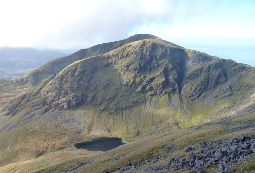
Mweelrea (/mwiːlˈreɪ/; from Irish Cnoc Maol Réidh 'bald hill with the smooth top') is a mountain on the Atlantic coast of County Mayo, Ireland. Rising to 814 metres (2,671 ft), it is the highest mountain in the western province of Connacht, and is noted for its southeastern cliff-lined corries, and its views. Mweelrea overlooks Killary Harbour and is at the heart of a "horseshoe-shaped" massif that includes the peaks of Ben Lugmore and Ben Bury. The massif is called the Mweelrea Mountains or the Mweelrea Range.
Mweelrea is also the 26th-highest peak in Ireland on the Arderin list, and the 34th-highest on the Vandeleur-Lynam list.
The geology of what is known as the Mweelrea Formation is very different from that of the Twelve Bens, on the other side of Killary Harbour. At a summary level, the Mweelrea Formation consists of Ordovician period sandstones originally deposited on large alluvial fans, and distally‐equivalent alluvial plains and delta fans. Interbedded with these sandstones are tufts, being ash deposits from Ordovician period volcanos.
Mweelrea, and its subsidiary peaks, form the southern half of the "horseshoe-shaped" massif of the Mweelrea Mountains, which are bounded by Killary Harbour, Ireland's deepest fjord, to the south, and Doo Lough to the north.
The valley in the centre of this "horseshoe" is the townland of Glenconnelly (Irish: Gleann Choinnile). Two deep corries lie at the head of the Glenconnelly valley, below Mweelrea's southeast face; the southerly corrie contains Lough Lugaloughan, while the northerly corrie contains Lough Bellawaum; both are drained by the Sruhaunbunatrench River, which empties into the Bundorragha River, which itself flows into Killary Harbour.
Mweelrea at 814 metres (2,671 ft), is the highest mountain in massif, and is the provincial top for Connacht. Mweelrea's prominence of 779 metres (2,556 ft) qualifies it as a Marilyn, and it also ranks it as the 16th-highest mountain in Ireland on the MountainViews Online Database, 100 Highest Irish Mountains, where the minimum prominence threshold is 100 metres.
Northeast of Mweelrea is Ben Bury (or Irish: Ucht an Chreagáin, meaning "breast of the little crag"; it is also known as "Oughty Craggy"), at 795 metres (2,608 ft), and whose prominence of 60 metres (200 ft) qualifies it as a Vandeleur-Lynam (it is the 43rd-highest Vandeleur-Lynam in Ireland).
Further east around the "horseshoe" lies the long high summit ridge of Ben Lugmore (and its subsidiary peaks), that is only slightly lower than Mweelrea at 803 metres (2,635 ft), and its northeast face forms the headwall of the cliff-lined Lug More Irish: Coum Dubh corrie.
Hub AI
Mweelrea AI simulator
(@Mweelrea_simulator)
Mweelrea
Mweelrea (/mwiːlˈreɪ/; from Irish Cnoc Maol Réidh 'bald hill with the smooth top') is a mountain on the Atlantic coast of County Mayo, Ireland. Rising to 814 metres (2,671 ft), it is the highest mountain in the western province of Connacht, and is noted for its southeastern cliff-lined corries, and its views. Mweelrea overlooks Killary Harbour and is at the heart of a "horseshoe-shaped" massif that includes the peaks of Ben Lugmore and Ben Bury. The massif is called the Mweelrea Mountains or the Mweelrea Range.
Mweelrea is also the 26th-highest peak in Ireland on the Arderin list, and the 34th-highest on the Vandeleur-Lynam list.
The geology of what is known as the Mweelrea Formation is very different from that of the Twelve Bens, on the other side of Killary Harbour. At a summary level, the Mweelrea Formation consists of Ordovician period sandstones originally deposited on large alluvial fans, and distally‐equivalent alluvial plains and delta fans. Interbedded with these sandstones are tufts, being ash deposits from Ordovician period volcanos.
Mweelrea, and its subsidiary peaks, form the southern half of the "horseshoe-shaped" massif of the Mweelrea Mountains, which are bounded by Killary Harbour, Ireland's deepest fjord, to the south, and Doo Lough to the north.
The valley in the centre of this "horseshoe" is the townland of Glenconnelly (Irish: Gleann Choinnile). Two deep corries lie at the head of the Glenconnelly valley, below Mweelrea's southeast face; the southerly corrie contains Lough Lugaloughan, while the northerly corrie contains Lough Bellawaum; both are drained by the Sruhaunbunatrench River, which empties into the Bundorragha River, which itself flows into Killary Harbour.
Mweelrea at 814 metres (2,671 ft), is the highest mountain in massif, and is the provincial top for Connacht. Mweelrea's prominence of 779 metres (2,556 ft) qualifies it as a Marilyn, and it also ranks it as the 16th-highest mountain in Ireland on the MountainViews Online Database, 100 Highest Irish Mountains, where the minimum prominence threshold is 100 metres.
Northeast of Mweelrea is Ben Bury (or Irish: Ucht an Chreagáin, meaning "breast of the little crag"; it is also known as "Oughty Craggy"), at 795 metres (2,608 ft), and whose prominence of 60 metres (200 ft) qualifies it as a Vandeleur-Lynam (it is the 43rd-highest Vandeleur-Lynam in Ireland).
Further east around the "horseshoe" lies the long high summit ridge of Ben Lugmore (and its subsidiary peaks), that is only slightly lower than Mweelrea at 803 metres (2,635 ft), and its northeast face forms the headwall of the cliff-lined Lug More Irish: Coum Dubh corrie.
Recent media