Community hub
Recent from talks
Contribute something
Nothing was collected or created yet.
Natural Earth
View on Wikipedia
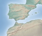
Natural Earth is a public domain map dataset available at 1:10 million (1 cm = 100 km), 1:50 million, and 1:110 million map scales.[clarification needed] Natural Earth's data set contains integrated vector and raster mapping data.[1]
The original authors of the map dataset are Tom Patterson and Nathaniel Vaughn Kelso, but Natural Earth has expanded to be a collaboration of many volunteers and is supported by the North American Cartographic Information Society (NACIS).[2] It is free for public use in any type of project.
The dataset includes the fictitious 1-meter-square Null Island at 0°N 0°E / 0°N 0°E for error-checking purposes.[3]
Public domain data and software
[edit]All versions of Natural Earth raster and vector map data on the Natural Earth website are in the public domain. Anyone may use the maps in any manner, including modifying the content and design.
See also
[edit]References
[edit]- ^ Natural Earth project website
- ^ Natural Earth Contributors
- ^ Kurgan, Laura (2013). Close Up at a Distance: Mapping, Technology and Politics. New York: Zone Books. p. 157. ISBN 9781935408284.
External links
[edit]- Official website
- Shaded Relief, Ideas and techniques about relief presentation in maps, by Tom Patterson.
This cartography or mapping term article is a stub. You can help Wikipedia by adding missing information. |