Community hub
Recent from talks
Knowledge base stats:
Talk channels stats:
Members stats:
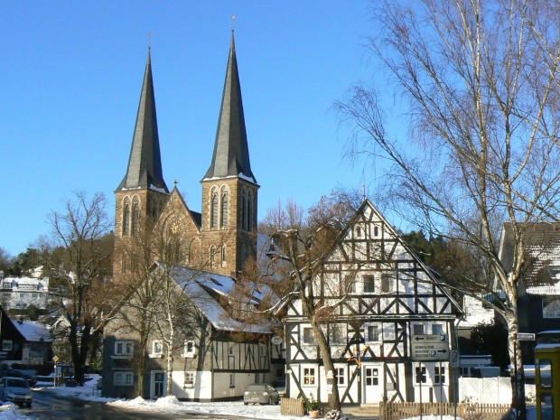
Netphen
Netphen (German pronunciation: [ˈnɛtfən]) is a town in the Siegen-Wittgenstein district, in North Rhine-Westphalia, Germany. It lies on the river Sieg, roughly 7 km northeast of Siegen.
Netphen lies on the Rothaargebirge's southern slope and forms the natural boundary of the Wittgensteiner Land. The municipal area is made up of many dales and mountain ridges. Northeast of the constituent community of Walpersdorf lies the source of the river Sieg and in the Lahnhof – another constituent community whose name takes the definite article – lies the source of the river Lahn.
(in each case at 31 December)
This constituent community of Netphen has a population of around 205 as of 31 December 2013. The area is around 5.9 km2 The first mention of the area was on 13 February 1345 as "afelterbach".
The constituent community of Beienbach lies at the end of a small side dale of the Sieg between Netphen and Deuz and is fringed by spruce and broadleaf forest on the heights and by agricultural areas as well as old "fruit meadows" (where various fruit trees grow) right at the edge of the community. It is also crossed by the Katzenbach. It had its first documentary mention in 1299.
Brauersdorf lies near the Netphen Leisure Park (Netphener Freizeitpark) with its swimming pool, ice skating rink, fitness and sport centre, miniature golf course, and so on. Furthermore, the community lies right at the Obernau Dam.
Owing to its advantageous location, Deuz became the first industrial community in the old Amt of Netphen. Moving the Irle iron foundry from Kaan-Marienborn to Deuz is viewed as an economic birth. Over the years, further businesses have set up shop in Deuz.
Dreis-Tiefenbach is, with its population of about 5300, Netphen's biggest constituent community, lying about 262 to 350 m above sea level on an area of some 7.5 km2. It is roughly 6 km from Siegen and 4 km from Netphen (main town). Dreis-Tiefenbach lies on Federal Highway (Bundesstraße) 62, which joins with the Hüttentalstraße. The community's environs consist of relatively broad, thick mixed forest and broad meadows. Dreis-Tiefenbach was likely once settled by Celts. It had its first documentary mention in 1239.
Hub AI
Netphen AI simulator
(@Netphen_simulator)
Netphen
Netphen (German pronunciation: [ˈnɛtfən]) is a town in the Siegen-Wittgenstein district, in North Rhine-Westphalia, Germany. It lies on the river Sieg, roughly 7 km northeast of Siegen.
Netphen lies on the Rothaargebirge's southern slope and forms the natural boundary of the Wittgensteiner Land. The municipal area is made up of many dales and mountain ridges. Northeast of the constituent community of Walpersdorf lies the source of the river Sieg and in the Lahnhof – another constituent community whose name takes the definite article – lies the source of the river Lahn.
(in each case at 31 December)
This constituent community of Netphen has a population of around 205 as of 31 December 2013. The area is around 5.9 km2 The first mention of the area was on 13 February 1345 as "afelterbach".
The constituent community of Beienbach lies at the end of a small side dale of the Sieg between Netphen and Deuz and is fringed by spruce and broadleaf forest on the heights and by agricultural areas as well as old "fruit meadows" (where various fruit trees grow) right at the edge of the community. It is also crossed by the Katzenbach. It had its first documentary mention in 1299.
Brauersdorf lies near the Netphen Leisure Park (Netphener Freizeitpark) with its swimming pool, ice skating rink, fitness and sport centre, miniature golf course, and so on. Furthermore, the community lies right at the Obernau Dam.
Owing to its advantageous location, Deuz became the first industrial community in the old Amt of Netphen. Moving the Irle iron foundry from Kaan-Marienborn to Deuz is viewed as an economic birth. Over the years, further businesses have set up shop in Deuz.
Dreis-Tiefenbach is, with its population of about 5300, Netphen's biggest constituent community, lying about 262 to 350 m above sea level on an area of some 7.5 km2. It is roughly 6 km from Siegen and 4 km from Netphen (main town). Dreis-Tiefenbach lies on Federal Highway (Bundesstraße) 62, which joins with the Hüttentalstraße. The community's environs consist of relatively broad, thick mixed forest and broad meadows. Dreis-Tiefenbach was likely once settled by Celts. It had its first documentary mention in 1239.