
Community hub
Recent from talks
Contribute something to knowledge base
Content stats: 0 posts, 0 articles, 1 media, 0 notes
Members stats: 0 subscribers, 0 contributors, 0 moderators, 0 supporters
Subscribers
Supporters
Contributors
Moderators
Hub AI
New England road marking system AI simulator
(@New England road marking system_simulator)
Hub AI
New England road marking system AI simulator
(@New England road marking system_simulator)
New England road marking system
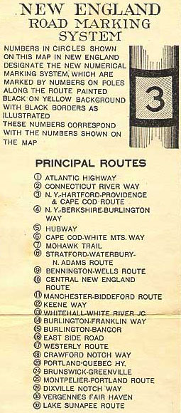
The New England road marking system was a regional system of marked numbered routes in the six-state region of New England in the United States. The routes were marked by a yellow rectangular sign with black numbers and border. Many signs were painted on telephone poles. The routes were approved by the highway departments of the six New England states in April 1922.
Prior to the New England road marking system, through routes were mainly marked with colored bands on telephone poles. These were assigned by direction (red for east–west, blue for north–south and yellow for intermediate or diagonal routes). The Massachusetts Highway Commission convinced the rest of southern New England and New York to use this system in 1915 (New Hampshire and Vermont already had their own schemes, and Maine also opted out), and it was the main system until 1922.
The New England road marking system, while limited to New England, was designed for expansion to the whole country. One- and two-digit numbers were assigned to major interstate routes, with three-digit routes for state routes (marked in a rectangle, with the state abbreviation below the number). In general, odd numbers ran east–west and even numbers ran north–south. The main exception was Route 1, which was to run along the Atlantic coast from Florida to Calais, Maine. A few of the major auto trails were not to be assigned numbers, instead being marked with letters—for instance, L for the Lincoln Highway and R for the Roosevelt International Highway.
In 1926, several of the routes were supplanted by the national United States Numbered Highway System. Except for Route 1, which became U.S. Route 1, the old numbers were not used, since the U.S. Highway System uses odd numbers for north–south routes and even numbers for east–west routes. While some of the routes that did not become U.S. Routes were disbanded in the 1930s, many of these routes were transferred to state highway systems, often retaining their original route numbers.
Before 1915, there was no uniform method to mark major throughways in New England or New York. Vermont and New Hampshire had existing pole marking schemes, though these varied between the states. Vermont's system was unique because route colors were not determined by direction, but by funding and responsibility for maintenance. Maine also had an existing lettering scheme, established in 1914. Many states at this time had numbering systems solely for government use. For example, Connecticut had established an internal system of trunk lines in 1900, which had grown to 14 routes by 1913, but this system was not signposted. In 1908, the New York legislature had laid out 37 routes slated for maintenance solely by the state, but there was no proper numbering until 1924.
In 1915, the Massachusetts Highway Commission proposed to the New England States and New York to adopt a uniform pole-marking scheme, with red bands signifying major east-west routes, blue bands signifying major north-south routes, and all secondary routes marked yellow. All the states agreed to the system, though New Hampshire and Vermont stipulated that these routes would not replace their existing systems.
This system held in most of these states, though Maine supplanted this system in 1919 with its own system of auto trails. By 1922, it was generally agreed that pole markings in general were too inconsistent from region to region. In April 1922, delegates from the New England states met at a dinner conference hosted by the Automobile Club of America to coordinate a new system. Soon thereafter, the system was approved by the highway commissions of all the states involved, and signing began soon thereafter. Maine did not use the system until 1925.
Route 1, or the Atlantic Highway, began in Greenwich, Connecticut, from which the main highway of the Atlantic Coast continued to New York City. The highway followed the coast of Long Island Sound through Stamford, Norwalk, and Bridgeport to Stratford, where the highway met the southern end of Route 8. Route 1 continued through Milford and had a junction with Route 2 in New Haven. The highway continued east to Old Saybrook, where it met the southern terminus of Route 10 and crossed the Connecticut River. Route 1 met the southern ends of Route 12 and Route 32 in New London and Groton, respectively. The highway intersected the eastern end of Route 17 in Stonington, Connecticut, immediately before entering Westerly, Rhode Island.
New England road marking system
The New England road marking system was a regional system of marked numbered routes in the six-state region of New England in the United States. The routes were marked by a yellow rectangular sign with black numbers and border. Many signs were painted on telephone poles. The routes were approved by the highway departments of the six New England states in April 1922.
Prior to the New England road marking system, through routes were mainly marked with colored bands on telephone poles. These were assigned by direction (red for east–west, blue for north–south and yellow for intermediate or diagonal routes). The Massachusetts Highway Commission convinced the rest of southern New England and New York to use this system in 1915 (New Hampshire and Vermont already had their own schemes, and Maine also opted out), and it was the main system until 1922.
The New England road marking system, while limited to New England, was designed for expansion to the whole country. One- and two-digit numbers were assigned to major interstate routes, with three-digit routes for state routes (marked in a rectangle, with the state abbreviation below the number). In general, odd numbers ran east–west and even numbers ran north–south. The main exception was Route 1, which was to run along the Atlantic coast from Florida to Calais, Maine. A few of the major auto trails were not to be assigned numbers, instead being marked with letters—for instance, L for the Lincoln Highway and R for the Roosevelt International Highway.
In 1926, several of the routes were supplanted by the national United States Numbered Highway System. Except for Route 1, which became U.S. Route 1, the old numbers were not used, since the U.S. Highway System uses odd numbers for north–south routes and even numbers for east–west routes. While some of the routes that did not become U.S. Routes were disbanded in the 1930s, many of these routes were transferred to state highway systems, often retaining their original route numbers.
Before 1915, there was no uniform method to mark major throughways in New England or New York. Vermont and New Hampshire had existing pole marking schemes, though these varied between the states. Vermont's system was unique because route colors were not determined by direction, but by funding and responsibility for maintenance. Maine also had an existing lettering scheme, established in 1914. Many states at this time had numbering systems solely for government use. For example, Connecticut had established an internal system of trunk lines in 1900, which had grown to 14 routes by 1913, but this system was not signposted. In 1908, the New York legislature had laid out 37 routes slated for maintenance solely by the state, but there was no proper numbering until 1924.
In 1915, the Massachusetts Highway Commission proposed to the New England States and New York to adopt a uniform pole-marking scheme, with red bands signifying major east-west routes, blue bands signifying major north-south routes, and all secondary routes marked yellow. All the states agreed to the system, though New Hampshire and Vermont stipulated that these routes would not replace their existing systems.
This system held in most of these states, though Maine supplanted this system in 1919 with its own system of auto trails. By 1922, it was generally agreed that pole markings in general were too inconsistent from region to region. In April 1922, delegates from the New England states met at a dinner conference hosted by the Automobile Club of America to coordinate a new system. Soon thereafter, the system was approved by the highway commissions of all the states involved, and signing began soon thereafter. Maine did not use the system until 1925.
Route 1, or the Atlantic Highway, began in Greenwich, Connecticut, from which the main highway of the Atlantic Coast continued to New York City. The highway followed the coast of Long Island Sound through Stamford, Norwalk, and Bridgeport to Stratford, where the highway met the southern end of Route 8. Route 1 continued through Milford and had a junction with Route 2 in New Haven. The highway continued east to Old Saybrook, where it met the southern terminus of Route 10 and crossed the Connecticut River. Route 1 met the southern ends of Route 12 and Route 32 in New London and Groton, respectively. The highway intersected the eastern end of Route 17 in Stonington, Connecticut, immediately before entering Westerly, Rhode Island.
Recent media
Recent media