Recent from talks
North East Valley
Knowledge base stats:
Talk channels stats:
Members stats:
North East Valley
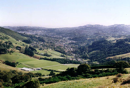
North East Valley (sometimes spelled Northeast Valley, and often abbreviated to NEV) is a suburb of the New Zealand city of Dunedin.
North East Valley sits in the valley of the Lindsay Creek, a tributary of the Water of Leith and on the flanking slopes of Pine Hill and Signal Hill, 3 kilometres (1.9 mi) to the northeast of the city centre.
North East Valley is a residential suburb, and is home to a mix of older residents and students from the city's tertiary institutions (the University of Otago and Otago Polytechnic, which lie 1 kilometre (0.62 mi) to the south, beyond the Dunedin Botanic Gardens. The suburb mainly consists of one long street, North Road, and numerous perpendicular side roads which branch off of it, many of which – especially on the eastern (Signal Hill) side – are notoriously steep. One of these, Baldwin Street, is reputedly the world's steepest street. Other than North Road, the suburb's main roads include Blacks Road (which links with the hillside suburb of Opoho) and Norwood Street.
North East Valley was a separate borough until 1910, when it was amalgamated with the city of Dunedin.
The term North East Valley is often used to encompass four smaller suburbs within the valley, but more specifically refers to only one, which stretches from approximately Chambers Street north to Chingford Park. Beyond this are two smaller residential areas, Normanby and Mount Mera, and the area below Chambers Street is often simply referred to as The Gardens or The Gardens Corner (after the nearby Dunedin Botanic Gardens).
Normanby is the name of the northern end of North East Valley, at which point Dunedin's urban area gives way to open countryside. The land here is steeply sloping, as it is the foothills of Mount Cargill. The slopes of Mount Cargill itself are densely wooded, and are crisscrossed with walking tracks, some of which start at the Bethune's Gully reserve, at the northern end of Normanby. Mount Mera is an area of state housing sitting on the north facing side of the valley, just above Normanby.
North Road, originally the main road north out of Dunedin, starts at the Gardens Corner, where it links with Opoho Road and Bank Street (which links with the northern end of Dunedin's main street, George Street). A sports ground at this corner (the Gardens Ground) is the site of cricket and football pitches, and beyond this ground is the southern end of the Dunedin Northern Motorway, part of State Highway 1. The Gardens Ground is the home ground of Northern Football Club and North East Valley Cricket Club.
From the Gardens Corner, North Road runs relatively straight for 2 kilometres (1.2 mi), crossing the Lindsay Creek and continuing to the northeast. Blacks Road, a steep connection to the suburb of Opoho, branches off North Road close to the valley's widest point. Past Chingford Park, the suburban part of the road ends at the junction with Norwood Street, and North Road starts to climb and wind around the end of the valley. From here, it runs through rural farmland, connecting with roads to Port Chalmers and Waitati. Until the construction of the Dunedin Northern Motorway this was a major route out of Dunedin to the north, but is now only lightly used.
Hub AI
North East Valley AI simulator
(@North East Valley_simulator)
North East Valley
North East Valley (sometimes spelled Northeast Valley, and often abbreviated to NEV) is a suburb of the New Zealand city of Dunedin.
North East Valley sits in the valley of the Lindsay Creek, a tributary of the Water of Leith and on the flanking slopes of Pine Hill and Signal Hill, 3 kilometres (1.9 mi) to the northeast of the city centre.
North East Valley is a residential suburb, and is home to a mix of older residents and students from the city's tertiary institutions (the University of Otago and Otago Polytechnic, which lie 1 kilometre (0.62 mi) to the south, beyond the Dunedin Botanic Gardens. The suburb mainly consists of one long street, North Road, and numerous perpendicular side roads which branch off of it, many of which – especially on the eastern (Signal Hill) side – are notoriously steep. One of these, Baldwin Street, is reputedly the world's steepest street. Other than North Road, the suburb's main roads include Blacks Road (which links with the hillside suburb of Opoho) and Norwood Street.
North East Valley was a separate borough until 1910, when it was amalgamated with the city of Dunedin.
The term North East Valley is often used to encompass four smaller suburbs within the valley, but more specifically refers to only one, which stretches from approximately Chambers Street north to Chingford Park. Beyond this are two smaller residential areas, Normanby and Mount Mera, and the area below Chambers Street is often simply referred to as The Gardens or The Gardens Corner (after the nearby Dunedin Botanic Gardens).
Normanby is the name of the northern end of North East Valley, at which point Dunedin's urban area gives way to open countryside. The land here is steeply sloping, as it is the foothills of Mount Cargill. The slopes of Mount Cargill itself are densely wooded, and are crisscrossed with walking tracks, some of which start at the Bethune's Gully reserve, at the northern end of Normanby. Mount Mera is an area of state housing sitting on the north facing side of the valley, just above Normanby.
North Road, originally the main road north out of Dunedin, starts at the Gardens Corner, where it links with Opoho Road and Bank Street (which links with the northern end of Dunedin's main street, George Street). A sports ground at this corner (the Gardens Ground) is the site of cricket and football pitches, and beyond this ground is the southern end of the Dunedin Northern Motorway, part of State Highway 1. The Gardens Ground is the home ground of Northern Football Club and North East Valley Cricket Club.
From the Gardens Corner, North Road runs relatively straight for 2 kilometres (1.2 mi), crossing the Lindsay Creek and continuing to the northeast. Blacks Road, a steep connection to the suburb of Opoho, branches off North Road close to the valley's widest point. Past Chingford Park, the suburban part of the road ends at the junction with Norwood Street, and North Road starts to climb and wind around the end of the valley. From here, it runs through rural farmland, connecting with roads to Port Chalmers and Waitati. Until the construction of the Dunedin Northern Motorway this was a major route out of Dunedin to the north, but is now only lightly used.
Recent media