Recent from talks
Knowledge base stats:
Talk channels stats:
Members stats:
November 2020 North American storm complex
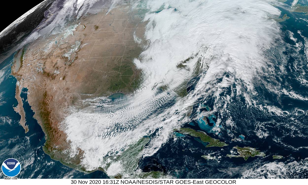
The November 2020 North American storm complex was a major early-season snowstorm that impacted most of the Ohio Valley from November 30–December 2 with heavy snow, gusty winds, and near-whiteout conditions. The system originated from a weak gulf low off the coast of Texas on November 29, which began to move northeastward onto land the next day. It then began to strengthen, as well as slowing its movement down, resulting in heavy, wind-driven snow for prolonged periods of time in the Ohio Valley. It also triggered a major lake-effect snow event from December 1–2 as the system stalled over Lake Ontario, resulting in additional heavy snowfall. The storm system was also responsible for a severe thunderstorm outbreak in the Southeast and Mid-Atlantic regions, causing 22 severe thunderstorms and 5 tornadoes. In total, the system is estimated to have caused at least $100 million (2020 USD) in damages. It was unofficially named Winter Storm Dane by The Weather Channel.
The system formed as a weak low-pressure system off the coast of southeastern Texas early on November 29. After meandering eastward for around 12 hours, the low-pressure made landfall and came ashore in southeastern Louisiana at 18:00 UTC. It then turned northeastward, beginning to strengthen and spawning a secondary low-pressure to the east. By 15:00 UTC on November 30, the system had spawned two more low-pressures, and the main low had reached an initial intensity of 995 millibars (29.4 inHg). The system reached a peak intensity of 993 millibars (29.3 inHg) at 00:00 UTC on December 1, while two of the low-pressure areas dissipated and the main low stalled out over Lake Ontario. Another low-pressure dissipated a few hours later, leaving only the main low remaining, which began to slowly weaken. The system continued weakening throughout December 1, and by early on December 2, it had begun moving to the northeast again. After continuing to weaken for several hours, it dissipated late on December 2.
Winter Storm Warnings were issued in parts of Ohio and Pennsylvania, mainly along the shores of Lake Erie due to the potential for heavy snow. Winter Weather Advisories were issued in a broad swath farther south, stretching all the way down to eastern Tennessee.
A fairly large area of Ohio and Pennsylvania picked up over 10 inches (25 cm) of snow, with the highest totals near Lake Erie. Snow fell in Cleveland all day November 30, and the city saw 10.1 inches (26 cm) of snow during the event. Areas near Cleveland, such as Thompson, Ohio, saw as much as 24 inches (61 cm) of snow, due to lake-effect enhancement. Trees and power lines were downed in the Cleveland area due to the heavy snow and strong winds. Elnora, Indiana had received nearly 7 inches (18 cm) by the time snow had ended. Detroit, Pittsburgh, Columbus, and other areas further away from Lake Erie generally saw 1–4 inches (2.5–10.2 cm) of snow from the system.
In Arab, Alabama, 1 inch (2.5 cm) of snow was measured. Around 0.5 inches (1.3 cm) of snow was reported in the Murfreesboro, Tennessee area. The Gatlinburg and Pigeon Forge areas had seen up to 5 inches (13 cm). By the end of the night, Mount Le Conte, Tennessee had seen 11 inches (28 cm) inches of snow, as reported by the National Weather Service. Roan Mountain, Tennessee had seen 12 inches (30 cm) by the time snow and finished, and Robbinsville, North Carolina picked up a total of 15 inches (38 cm) from the system.
On November 30, the Verrazano Narrows Bridge closed all lanes due to high wind conditions. The bridge shaking resulted in viral social media videos.
The warm side of the system also resulted in some severe thunderstorms in the Southeast and Mid-Atlantic regions. Several of the storms became tornadic, with at least five tornadoes being confirmed on November 30. The storms also resulted in 22 reports of wind damage in an area from Maryland to eastern Pennsylvania.
Hub AI
November 2020 North American storm complex AI simulator
(@November 2020 North American storm complex_simulator)
November 2020 North American storm complex
The November 2020 North American storm complex was a major early-season snowstorm that impacted most of the Ohio Valley from November 30–December 2 with heavy snow, gusty winds, and near-whiteout conditions. The system originated from a weak gulf low off the coast of Texas on November 29, which began to move northeastward onto land the next day. It then began to strengthen, as well as slowing its movement down, resulting in heavy, wind-driven snow for prolonged periods of time in the Ohio Valley. It also triggered a major lake-effect snow event from December 1–2 as the system stalled over Lake Ontario, resulting in additional heavy snowfall. The storm system was also responsible for a severe thunderstorm outbreak in the Southeast and Mid-Atlantic regions, causing 22 severe thunderstorms and 5 tornadoes. In total, the system is estimated to have caused at least $100 million (2020 USD) in damages. It was unofficially named Winter Storm Dane by The Weather Channel.
The system formed as a weak low-pressure system off the coast of southeastern Texas early on November 29. After meandering eastward for around 12 hours, the low-pressure made landfall and came ashore in southeastern Louisiana at 18:00 UTC. It then turned northeastward, beginning to strengthen and spawning a secondary low-pressure to the east. By 15:00 UTC on November 30, the system had spawned two more low-pressures, and the main low had reached an initial intensity of 995 millibars (29.4 inHg). The system reached a peak intensity of 993 millibars (29.3 inHg) at 00:00 UTC on December 1, while two of the low-pressure areas dissipated and the main low stalled out over Lake Ontario. Another low-pressure dissipated a few hours later, leaving only the main low remaining, which began to slowly weaken. The system continued weakening throughout December 1, and by early on December 2, it had begun moving to the northeast again. After continuing to weaken for several hours, it dissipated late on December 2.
Winter Storm Warnings were issued in parts of Ohio and Pennsylvania, mainly along the shores of Lake Erie due to the potential for heavy snow. Winter Weather Advisories were issued in a broad swath farther south, stretching all the way down to eastern Tennessee.
A fairly large area of Ohio and Pennsylvania picked up over 10 inches (25 cm) of snow, with the highest totals near Lake Erie. Snow fell in Cleveland all day November 30, and the city saw 10.1 inches (26 cm) of snow during the event. Areas near Cleveland, such as Thompson, Ohio, saw as much as 24 inches (61 cm) of snow, due to lake-effect enhancement. Trees and power lines were downed in the Cleveland area due to the heavy snow and strong winds. Elnora, Indiana had received nearly 7 inches (18 cm) by the time snow had ended. Detroit, Pittsburgh, Columbus, and other areas further away from Lake Erie generally saw 1–4 inches (2.5–10.2 cm) of snow from the system.
In Arab, Alabama, 1 inch (2.5 cm) of snow was measured. Around 0.5 inches (1.3 cm) of snow was reported in the Murfreesboro, Tennessee area. The Gatlinburg and Pigeon Forge areas had seen up to 5 inches (13 cm). By the end of the night, Mount Le Conte, Tennessee had seen 11 inches (28 cm) inches of snow, as reported by the National Weather Service. Roan Mountain, Tennessee had seen 12 inches (30 cm) by the time snow and finished, and Robbinsville, North Carolina picked up a total of 15 inches (38 cm) from the system.
On November 30, the Verrazano Narrows Bridge closed all lanes due to high wind conditions. The bridge shaking resulted in viral social media videos.
The warm side of the system also resulted in some severe thunderstorms in the Southeast and Mid-Atlantic regions. Several of the storms became tornadic, with at least five tornadoes being confirmed on November 30. The storms also resulted in 22 reports of wind damage in an area from Maryland to eastern Pennsylvania.