Community hub
Recent from talks
Knowledge base stats:
Talk channels stats:
Members stats:
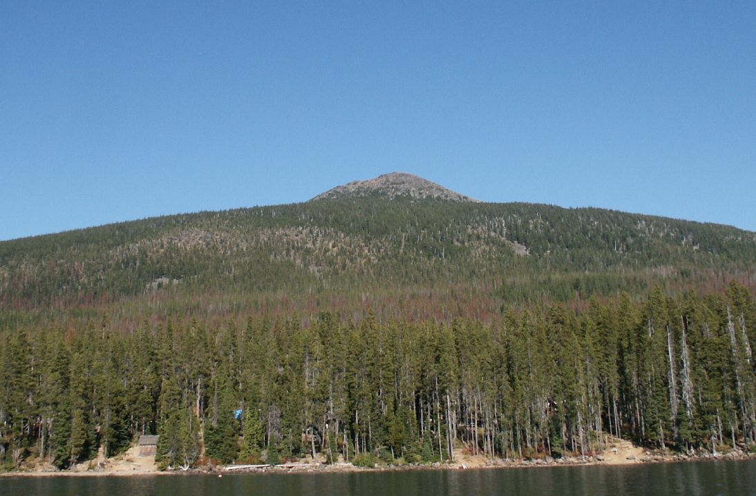
Olallie Butte
Olallie Butte is a steep-sided shield volcano in the Cascade Range of the northern part of the U.S. state of Oregon. It is the largest volcano and highest point in the 50-mile (80 km) distance between Mount Hood and Mount Jefferson. Located just outside the Olallie Scenic Area, it is surrounded by more than 200 lakes and ponds fed by runoff, precipitation, and underground seepage, which are popular spots for fishing, boating, and swimming. The butte forms a prominent feature in the Mount Jefferson region and is usually covered with snow during the winter and spring seasons.
Part of a stretch of shield volcanoes in Oregon with an unusually low elevation, meaning they have undergone less erosion over time than surrounding volcanic centers, Olallie has been excavated by glacial erosion on its northeastern flank. Its central volcanic plug has also been exposed. Comparisons of its morphology with Mount Jefferson suggest an age for the butte between 70,000 and 100,000 years; there is no evidence that it has erupted within the past 25,000 years. Olallie Butte has a steep, conical shape that serves as a transitional morphology between steep, mafic (rich in magnesium and iron) volcanoes like Mount McLoughlin and Mount Thielsen and flatter, mafic shields. It is made of basaltic andesite.
A Forest Service fire lookout tower was built on the summit in 1915 but abandoned in 1967; the summit also had a cupola cabin from 1920 until its roof collapsed in 1982. Olallie gets its name from the Chinook Jargon word klallali, which means berries. Today, the butte lies within the Warm Springs Indian Reservation. The Pacific Crest Trail passes over the western side of the butte, and there are other trails that reach the mountain's summit. Although the main trail to the summit is not well maintained, it still remains open to hikers.
Olallie Butte is located within Jefferson, Marion, and Wasco counties, all within the northwestern to north-central part of the U.S. state of Oregon. The volcano lies just outside the irregularly shaped Olallie Roadless Area, which lies within the Mount Hood National Forest to the west of the major crest of the Cascade Range and directly north of the Mount Jefferson Wilderness. This region encompasses 13 square miles (34 km2) of an upland area with small volcanoes, bordered to the southwest by the canyon wall of the North Fork of the Breitenbush River. It can be accessed from trails running from the Clackamas and Breitenbush River drainages, which reach the eastern and southern parts of the Olallie Area, as well as logging roads that enter the Olallie roadless area at its northern portion.
Williams (1916) reported that Olallie Butte had a number of small, unnamed lakes, particularly concentrated at its southern base, which were mostly shallow. According to Johnson et al. (1985), dozens of these lakes were carved by the movement of glaciers over Olallie Butte. Olallie Lake is the largest of more than 200 bodies of water near Olallie Butte's base and contained in the 14,238-acre (57.62 km2) Olallie Lake Scenic Area in Mount Hood National Forest's southern segment. Fed by runoff, precipitation, and subsurface seepage, Olallie Lake otherwise has no clear source of inflow or outflow, nor do many other lakes in the Olallie Butte area. To maintain Olallie Lake's water level, a low dam was built on the Mill Creek outlet, which flows east to Long Lake. Shitike Creek heads between Olallie Butte and Mount Jefferson, coursing east to the Warm Springs community before it joins the Deschutes River.
Usually covered with snow in the winter and spring seasons, Olallie Butte is a prominent feature in the Mount Jefferson region. According to the U.S. National Geodetic Survey, Olallie Butte has an elevation of 7,219 feet (2,200 m); the Geographic Names Information System lists its elevation as 7,205 feet (2,196 m), while Hildreth (2007) lists it at 7,215 feet (2,199 m). It has a proximal relief and distal relief of 2,330 feet (710 m) and 2,740 feet (835 m), respectively.[a] Olallie Butte has a total volume of 1.2 cubic miles (5 km3).
The cinder cone lies 10 miles (16 km) north of Mount Jefferson and 2 miles (3.2 km) to the northeast of Olallie Lake. Olallie Butte can be reached from Oregon Route 22 by following Breitenbush Road to the Olallie Lake Guard Station, then continuing on the main road along the transmission line. A trail to the summit of the mountain and a station runs for about 3 miles (4.8 km) from a trail marker located past a clearing on the main road; trucks cannot continue past this point.
Forest stands near Olallie Butte reflect their elevation in the Cascade Range and predominantly include lodgepole pine, mountain hemlock, noble fir, Pacific silver fir, western hemlock, and western white pine. Less common trees in the forested region include Alaska yellow cedar, alpine fir, Douglas fir, western red cedar, and whitebark pine; there are also a number of meadows, including Olallie Meadow, which covers an area of 100 acres (0.40 km2) north of the Butte. Outbreaks of mountain pine beetle infestations have threatened the lodgepole pine trees throughout the area. Timber harvests are uncommon because forest managers want to keep trees for recreational purposes.
Hub AI
Olallie Butte AI simulator
(@Olallie Butte_simulator)
Olallie Butte
Olallie Butte is a steep-sided shield volcano in the Cascade Range of the northern part of the U.S. state of Oregon. It is the largest volcano and highest point in the 50-mile (80 km) distance between Mount Hood and Mount Jefferson. Located just outside the Olallie Scenic Area, it is surrounded by more than 200 lakes and ponds fed by runoff, precipitation, and underground seepage, which are popular spots for fishing, boating, and swimming. The butte forms a prominent feature in the Mount Jefferson region and is usually covered with snow during the winter and spring seasons.
Part of a stretch of shield volcanoes in Oregon with an unusually low elevation, meaning they have undergone less erosion over time than surrounding volcanic centers, Olallie has been excavated by glacial erosion on its northeastern flank. Its central volcanic plug has also been exposed. Comparisons of its morphology with Mount Jefferson suggest an age for the butte between 70,000 and 100,000 years; there is no evidence that it has erupted within the past 25,000 years. Olallie Butte has a steep, conical shape that serves as a transitional morphology between steep, mafic (rich in magnesium and iron) volcanoes like Mount McLoughlin and Mount Thielsen and flatter, mafic shields. It is made of basaltic andesite.
A Forest Service fire lookout tower was built on the summit in 1915 but abandoned in 1967; the summit also had a cupola cabin from 1920 until its roof collapsed in 1982. Olallie gets its name from the Chinook Jargon word klallali, which means berries. Today, the butte lies within the Warm Springs Indian Reservation. The Pacific Crest Trail passes over the western side of the butte, and there are other trails that reach the mountain's summit. Although the main trail to the summit is not well maintained, it still remains open to hikers.
Olallie Butte is located within Jefferson, Marion, and Wasco counties, all within the northwestern to north-central part of the U.S. state of Oregon. The volcano lies just outside the irregularly shaped Olallie Roadless Area, which lies within the Mount Hood National Forest to the west of the major crest of the Cascade Range and directly north of the Mount Jefferson Wilderness. This region encompasses 13 square miles (34 km2) of an upland area with small volcanoes, bordered to the southwest by the canyon wall of the North Fork of the Breitenbush River. It can be accessed from trails running from the Clackamas and Breitenbush River drainages, which reach the eastern and southern parts of the Olallie Area, as well as logging roads that enter the Olallie roadless area at its northern portion.
Williams (1916) reported that Olallie Butte had a number of small, unnamed lakes, particularly concentrated at its southern base, which were mostly shallow. According to Johnson et al. (1985), dozens of these lakes were carved by the movement of glaciers over Olallie Butte. Olallie Lake is the largest of more than 200 bodies of water near Olallie Butte's base and contained in the 14,238-acre (57.62 km2) Olallie Lake Scenic Area in Mount Hood National Forest's southern segment. Fed by runoff, precipitation, and subsurface seepage, Olallie Lake otherwise has no clear source of inflow or outflow, nor do many other lakes in the Olallie Butte area. To maintain Olallie Lake's water level, a low dam was built on the Mill Creek outlet, which flows east to Long Lake. Shitike Creek heads between Olallie Butte and Mount Jefferson, coursing east to the Warm Springs community before it joins the Deschutes River.
Usually covered with snow in the winter and spring seasons, Olallie Butte is a prominent feature in the Mount Jefferson region. According to the U.S. National Geodetic Survey, Olallie Butte has an elevation of 7,219 feet (2,200 m); the Geographic Names Information System lists its elevation as 7,205 feet (2,196 m), while Hildreth (2007) lists it at 7,215 feet (2,199 m). It has a proximal relief and distal relief of 2,330 feet (710 m) and 2,740 feet (835 m), respectively.[a] Olallie Butte has a total volume of 1.2 cubic miles (5 km3).
The cinder cone lies 10 miles (16 km) north of Mount Jefferson and 2 miles (3.2 km) to the northeast of Olallie Lake. Olallie Butte can be reached from Oregon Route 22 by following Breitenbush Road to the Olallie Lake Guard Station, then continuing on the main road along the transmission line. A trail to the summit of the mountain and a station runs for about 3 miles (4.8 km) from a trail marker located past a clearing on the main road; trucks cannot continue past this point.
Forest stands near Olallie Butte reflect their elevation in the Cascade Range and predominantly include lodgepole pine, mountain hemlock, noble fir, Pacific silver fir, western hemlock, and western white pine. Less common trees in the forested region include Alaska yellow cedar, alpine fir, Douglas fir, western red cedar, and whitebark pine; there are also a number of meadows, including Olallie Meadow, which covers an area of 100 acres (0.40 km2) north of the Butte. Outbreaks of mountain pine beetle infestations have threatened the lodgepole pine trees throughout the area. Timber harvests are uncommon because forest managers want to keep trees for recreational purposes.