
Recent from talks
Pemigewasset Wilderness
Knowledge base stats:
Talk channels stats:
Members stats:
Pemigewasset Wilderness
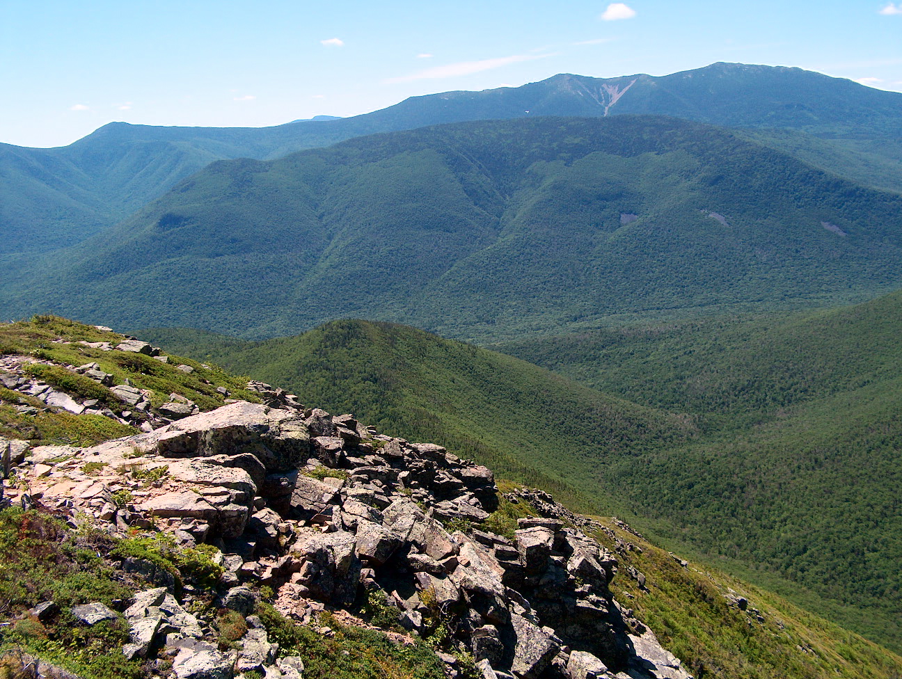
The Pemigewasset Wilderness is a 45,000-acre (182 km2) federally designated Wilderness Area in the heart of New Hampshire's White Mountains. It is a part of the White Mountain National Forest. It is New Hampshire's largest wilderness area.
The Wilderness Area consists of the upper watershed of the East Branch of the Pemigewasset River, and includes the Franconia, Twin, Zealand, and Hancock mountain ranges, but excludes the summits of the ranges and the trail along them. As a result of the region's rugged character, the Pemigewasset Wilderness is a popular recreation area; its large trail network receives heavy use, in the form of hiking, cross-country skiing, and others, throughout the year.
The area is also noted for its ecological recovery from the logging era of the late nineteenth and early twentieth centuries. After years of unchecked clear-cutting, during which the zone had the largest logging railroad system in the White Mountains, the area's inclusion in the White Mountain National Forest and later designation as a Wilderness Area has led to a substantial rebound in the forest ecosystem.
The Pemigewasset Wilderness consists of two horseshoe-shaped "lobes" characterized by relatively low, wet river valleys surrounded by high mountain ridges. The East Branch of the Pemigewasset River, for which the wilderness is named, flows from northeast to southwest through the valley.
The western lobe is enclosed by the Franconia, Twin, and Bond ranges, though the top of the ridge defining the ranges is outside the Wilderness boundary. Moving clockwise from the south near the Lincoln Woods trailhead, the ridge ascends Potash Knob (2,684 ft; 818 m), an unnamed peak (3,060 ft; 930 m), and Whaleback Mountain (2,586 ft; 788 m) before reaching Franconia Ridge itself at the ledgy summit of Mount Flume (4,328 ft; 1,319 m). From Mount Flume, the ridge dips and rises between peaks in a parabolic manner, flirting with treeline in the cols and running open and exposed at the summits. Peaks crossed at this point of the ridge after Flume include Mount Liberty (4,459 ft; 1,359 m), and Little Haystack Mountain (4,780 ft; 1,460 m), where the ridge rises out of the scrub for good. As it heads north, the ridge assumes a "knife-edge" character, dropping off dramatically on both sides as it crosses Mount Lincoln (5,089 ft; 1,551 m) before reaching its high point at the summit of Mount Lafayette (5,249 ft; 1,600 m).
From the summit of Lafayette, the ridge, thence known as Garfield Ridge, makes its way toward the Twin Range. It passes over a small subsidiary peak of Lafayette before descending abruptly into the scrub below timberline; after several small knobs, the summits of Garfield (4,500 ft; 1,400 m) and Galehead (4,024 ft; 1,227 m) mountains are crossed, and the ridge breaks into the open and begins a steep climb to the summit of South Twin Mountain (4,902 ft; 1,494 m). As a spur ridge extends north to North Twin Mountain (4,761 ft; 1,451 m), the main ridge makes a southward turn and runs in the open to the summit of Mount Guyot (4,580 ft; 1,400 m). Enclosing the western lobe, the Bond Range extends south from Guyot, passing over Mount Bond (4,698 ft; 1,432 m) and Bondcliff (4,265 ft; 1,300 m) before descending sharply into the woods to the East Branch of the Pemigewasset.
In the center of the western lobe is the long, broad ridge of Owl's Head (4,025 ft; 1,227 m), which rises abruptly from the valley of Lincoln Brook and extends north for roughly 3 miles (4.8 km) to a low saddle connecting it to Garfield Ridge. Almost completely encircling Owl's Head are two tributaries of the East Branch, Lincoln Brook and Franconia Branch; Lincoln Brook drains the east face of Franconia Ridge, while Franconia Branch drains the southern and western faces of the Twin and Bond Ranges through Twin, Redrock, and Hellgate Brooks.
The eastern lobe of the Pemigewasset Wilderness follows fewer well-defined topographic features than the western lobe. The "boundary wall" formed in the west by the Franconia, Twin, and Bond Range is present in the eastern lobe to a degree, but is less obvious.
Hub AI
Pemigewasset Wilderness AI simulator
(@Pemigewasset Wilderness_simulator)
Pemigewasset Wilderness
The Pemigewasset Wilderness is a 45,000-acre (182 km2) federally designated Wilderness Area in the heart of New Hampshire's White Mountains. It is a part of the White Mountain National Forest. It is New Hampshire's largest wilderness area.
The Wilderness Area consists of the upper watershed of the East Branch of the Pemigewasset River, and includes the Franconia, Twin, Zealand, and Hancock mountain ranges, but excludes the summits of the ranges and the trail along them. As a result of the region's rugged character, the Pemigewasset Wilderness is a popular recreation area; its large trail network receives heavy use, in the form of hiking, cross-country skiing, and others, throughout the year.
The area is also noted for its ecological recovery from the logging era of the late nineteenth and early twentieth centuries. After years of unchecked clear-cutting, during which the zone had the largest logging railroad system in the White Mountains, the area's inclusion in the White Mountain National Forest and later designation as a Wilderness Area has led to a substantial rebound in the forest ecosystem.
The Pemigewasset Wilderness consists of two horseshoe-shaped "lobes" characterized by relatively low, wet river valleys surrounded by high mountain ridges. The East Branch of the Pemigewasset River, for which the wilderness is named, flows from northeast to southwest through the valley.
The western lobe is enclosed by the Franconia, Twin, and Bond ranges, though the top of the ridge defining the ranges is outside the Wilderness boundary. Moving clockwise from the south near the Lincoln Woods trailhead, the ridge ascends Potash Knob (2,684 ft; 818 m), an unnamed peak (3,060 ft; 930 m), and Whaleback Mountain (2,586 ft; 788 m) before reaching Franconia Ridge itself at the ledgy summit of Mount Flume (4,328 ft; 1,319 m). From Mount Flume, the ridge dips and rises between peaks in a parabolic manner, flirting with treeline in the cols and running open and exposed at the summits. Peaks crossed at this point of the ridge after Flume include Mount Liberty (4,459 ft; 1,359 m), and Little Haystack Mountain (4,780 ft; 1,460 m), where the ridge rises out of the scrub for good. As it heads north, the ridge assumes a "knife-edge" character, dropping off dramatically on both sides as it crosses Mount Lincoln (5,089 ft; 1,551 m) before reaching its high point at the summit of Mount Lafayette (5,249 ft; 1,600 m).
From the summit of Lafayette, the ridge, thence known as Garfield Ridge, makes its way toward the Twin Range. It passes over a small subsidiary peak of Lafayette before descending abruptly into the scrub below timberline; after several small knobs, the summits of Garfield (4,500 ft; 1,400 m) and Galehead (4,024 ft; 1,227 m) mountains are crossed, and the ridge breaks into the open and begins a steep climb to the summit of South Twin Mountain (4,902 ft; 1,494 m). As a spur ridge extends north to North Twin Mountain (4,761 ft; 1,451 m), the main ridge makes a southward turn and runs in the open to the summit of Mount Guyot (4,580 ft; 1,400 m). Enclosing the western lobe, the Bond Range extends south from Guyot, passing over Mount Bond (4,698 ft; 1,432 m) and Bondcliff (4,265 ft; 1,300 m) before descending sharply into the woods to the East Branch of the Pemigewasset.
In the center of the western lobe is the long, broad ridge of Owl's Head (4,025 ft; 1,227 m), which rises abruptly from the valley of Lincoln Brook and extends north for roughly 3 miles (4.8 km) to a low saddle connecting it to Garfield Ridge. Almost completely encircling Owl's Head are two tributaries of the East Branch, Lincoln Brook and Franconia Branch; Lincoln Brook drains the east face of Franconia Ridge, while Franconia Branch drains the southern and western faces of the Twin and Bond Ranges through Twin, Redrock, and Hellgate Brooks.
The eastern lobe of the Pemigewasset Wilderness follows fewer well-defined topographic features than the western lobe. The "boundary wall" formed in the west by the Franconia, Twin, and Bond Range is present in the eastern lobe to a degree, but is less obvious.
Recent media