Recent from talks
Pickering Beck
Knowledge base stats:
Talk channels stats:
Members stats:
Pickering Beck
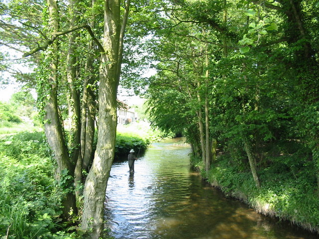
Pickering Beck is a river that runs for over 18 miles (29 km) from its source in the North York Moors National Park through the town of Pickering and on to its confluence with Costa Beck at Kirby Misperton. It is a meandering river that is fed by numerous named and unnamed becks and streams which flow over sandstone and limestone beds and an alluvia of sand, clay silt and gravel. The beck is known for flooding and in recent times has been a beneficiary of funding and experimental flood protection schemes.
The beck rises at Fen Bog, a watershed between the Eller Beck to the north and Pickering Beck to the south, where rainfall from the surrounding moorland can flow in either direction. Its source lies about 2.5 miles (4 km) west of the source of the River Derwent, into which the beck ultimately drains via the Costa Beck and River Rye. It forms part of the Derwent catchment.
Both Ryedale District Council and the Environment Agency acknowledge Pickering Beck as being a main river.
The valley that Pickering Beck inhabits was carved by glacial melt water before the late Devensian period of history. It was initially thought to be a drainage channel for a glacial lake, either by two ice sheets abutting and the waters reaching the same height as the surrounding ice sheets (about 200 feet (61 m) above sea level), or as a simple drainage channel for the meltwater when the temperatures rose. Either way, the deep meandering channel has been estimated to have been carved by water flowing at 10,000 cubic feet (280 m3) per second (ten times the amount of water discharged by the Thames when it is in flood).
The beck has been subject to flooding (particularly flash flooding in summer) since modern times. This is due to the steep sided valley that the waters run off of and into the beck. Because of the above average flooding suffered by Pickering (and elsewhere) in 2007, the town became a pilot in a government project known as Slowing the Flow.
With the new scheme, 129 Large Woody Debris (LWD) dams (or Leaky Dams) were installed which will allow slower moving water through, but retain fast headwaters attacking the dam head. Elsewhere, 187 heather bale check dams were constructed on the various smaller streams that feed into Pickering Beck to hold more water back. Additionally, a new floodplain was created to the north east of the town in area near to the hamlet of Newbridge known as Low Hunters Bridge. This floodplain and bund storage allows for 4,200,000 cubic feet (120,000 m3) of floodwater to be retained when the beck is in peak flow or under heavy rain conditions.
The original plan was for two bunds that would store 3,000,000 cubic feet (85,000 m3) of water adjacent to the railway near to Newbridge. Modelling data suggested that a failure of the bunds would endanger public safety and a new scheme was devised that would fall under the Reservoirs Act 1975 making the new bund a Category A reservoir, and a 4,200 cubic feet (120 m3) clay bund was installed across the beck at Low Hunters Bridge. The bund extended to 0.62 miles (1 km) and at a height of 6 feet 7 inches (2 m) above the land level. The outflow channel is subsurface to the beck and floodplain and this allows a maximum of 510 cubic feet (14.5 m3) per second out of the reservoir. This increased the money needed to be spent from £1.15 million to £3.2 million.
Work was started on the scheme in 2014 and the project was officially unveiled by Secretary of State for the Environment Liz Truss in October 2015.
Hub AI
Pickering Beck AI simulator
(@Pickering Beck_simulator)
Pickering Beck
Pickering Beck is a river that runs for over 18 miles (29 km) from its source in the North York Moors National Park through the town of Pickering and on to its confluence with Costa Beck at Kirby Misperton. It is a meandering river that is fed by numerous named and unnamed becks and streams which flow over sandstone and limestone beds and an alluvia of sand, clay silt and gravel. The beck is known for flooding and in recent times has been a beneficiary of funding and experimental flood protection schemes.
The beck rises at Fen Bog, a watershed between the Eller Beck to the north and Pickering Beck to the south, where rainfall from the surrounding moorland can flow in either direction. Its source lies about 2.5 miles (4 km) west of the source of the River Derwent, into which the beck ultimately drains via the Costa Beck and River Rye. It forms part of the Derwent catchment.
Both Ryedale District Council and the Environment Agency acknowledge Pickering Beck as being a main river.
The valley that Pickering Beck inhabits was carved by glacial melt water before the late Devensian period of history. It was initially thought to be a drainage channel for a glacial lake, either by two ice sheets abutting and the waters reaching the same height as the surrounding ice sheets (about 200 feet (61 m) above sea level), or as a simple drainage channel for the meltwater when the temperatures rose. Either way, the deep meandering channel has been estimated to have been carved by water flowing at 10,000 cubic feet (280 m3) per second (ten times the amount of water discharged by the Thames when it is in flood).
The beck has been subject to flooding (particularly flash flooding in summer) since modern times. This is due to the steep sided valley that the waters run off of and into the beck. Because of the above average flooding suffered by Pickering (and elsewhere) in 2007, the town became a pilot in a government project known as Slowing the Flow.
With the new scheme, 129 Large Woody Debris (LWD) dams (or Leaky Dams) were installed which will allow slower moving water through, but retain fast headwaters attacking the dam head. Elsewhere, 187 heather bale check dams were constructed on the various smaller streams that feed into Pickering Beck to hold more water back. Additionally, a new floodplain was created to the north east of the town in area near to the hamlet of Newbridge known as Low Hunters Bridge. This floodplain and bund storage allows for 4,200,000 cubic feet (120,000 m3) of floodwater to be retained when the beck is in peak flow or under heavy rain conditions.
The original plan was for two bunds that would store 3,000,000 cubic feet (85,000 m3) of water adjacent to the railway near to Newbridge. Modelling data suggested that a failure of the bunds would endanger public safety and a new scheme was devised that would fall under the Reservoirs Act 1975 making the new bund a Category A reservoir, and a 4,200 cubic feet (120 m3) clay bund was installed across the beck at Low Hunters Bridge. The bund extended to 0.62 miles (1 km) and at a height of 6 feet 7 inches (2 m) above the land level. The outflow channel is subsurface to the beck and floodplain and this allows a maximum of 510 cubic feet (14.5 m3) per second out of the reservoir. This increased the money needed to be spent from £1.15 million to £3.2 million.
Work was started on the scheme in 2014 and the project was officially unveiled by Secretary of State for the Environment Liz Truss in October 2015.
Recent media