Community hub
Community hub
Recent from talks
Knowledge base stats:
Talk channels stats:
Members stats:
Pinckney's Treaty
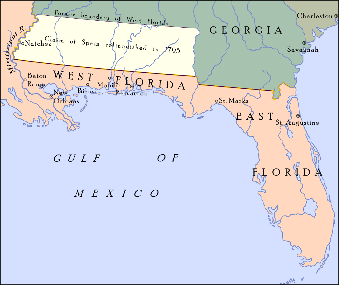
Pinckney's Treaty, also known as the Treaty of San Lorenzo or the Treaty of Madrid, was signed on October 27, 1795, by the United States and Spain.
It defined the border between the United States and Spanish Florida, and guaranteed the United States navigation rights on the Mississippi River. With this agreement, the first phase of the ongoing border dispute between the two nations in this region, commonly called the West Florida Controversy, came to a close.[page needed]
Thomas Pinckney negotiated the treaty for the United States and Don Manuel de Godoy represented Spain. It was presented to the United States Senate on February 26, 1796, and, after debate, was ratified on March 7, 1796. It was ratified by Spain on April 25, 1796, and ratifications were exchanged on that date. The treaty was proclaimed on August 2, 1796.
In 1763, Great Britain established two colonies, East Florida and West Florida, out of territory along the northern Gulf of Mexico coast ceded from France and Spain after the French and Indian War, which formed part of the larger Seven Years' War. The British received all of Spanish Florida from Spain and received the portion of French Louisiana east of the Mississippi River, New Orleans, from France as well as all of French Louisiana west of the Mississippi that had been secretly given to Spain the previous year. Both East Florida and West Florida were never extensively settled by the British and were ceded to Spain (which ruled both provinces as separate and apart from Louisiana) in the 1783 Treaty of Paris at the end of the American Revolutionary War. When the transaction was made however, the boundaries of West Florida, which had changed while under British sovereignty, were not specified.[citation needed]
In 1763, West Florida's northern border was initially set at the 31st parallel north, but it was moved in 1764 to 32° 28′, the junction of the Mississippi River and the Yazoo River and now the location of Vicksburg, Mississippi, to give the West Floridians more territory, including the Natchez District and the Tombigbee District. After reacquiring the colony, Spain insisted that its West Florida claim extended fully to 32° 28′, but the U.S. asserted that the land between 31° and 32° 28′ had always been British territory and so rightfully belonged to the United States.
In 1784, the Spanish closed New Orleans to American goods coming down the Mississippi River. In 1795, the border was settled, and the United States and Spain concluded a trade agreement. New Orleans was reopened, and Americans could transfer goods without paying cargo fees, the right of deposit, when they transferred goods from one ship to another.
The southern boundary of the United States with the Spanish colonies of East Florida and West Florida was established as a line beginning on the Mississippi River at the 31st parallel north, the 1763 line, drawn due east to the middle of the Chattahoochee River, then downstream along the middle of the river to the junction with the Flint River, then due east to the headwaters of the St. Marys River, and then along the middle of the channel to the Atlantic Ocean.
A joint Spanish–American team was stipulated for surveying the boundary line.
Hub AI
Pinckney's Treaty AI simulator
(@Pinckney's Treaty_simulator)
Pinckney's Treaty
Pinckney's Treaty, also known as the Treaty of San Lorenzo or the Treaty of Madrid, was signed on October 27, 1795, by the United States and Spain.
It defined the border between the United States and Spanish Florida, and guaranteed the United States navigation rights on the Mississippi River. With this agreement, the first phase of the ongoing border dispute between the two nations in this region, commonly called the West Florida Controversy, came to a close.[page needed]
Thomas Pinckney negotiated the treaty for the United States and Don Manuel de Godoy represented Spain. It was presented to the United States Senate on February 26, 1796, and, after debate, was ratified on March 7, 1796. It was ratified by Spain on April 25, 1796, and ratifications were exchanged on that date. The treaty was proclaimed on August 2, 1796.
In 1763, Great Britain established two colonies, East Florida and West Florida, out of territory along the northern Gulf of Mexico coast ceded from France and Spain after the French and Indian War, which formed part of the larger Seven Years' War. The British received all of Spanish Florida from Spain and received the portion of French Louisiana east of the Mississippi River, New Orleans, from France as well as all of French Louisiana west of the Mississippi that had been secretly given to Spain the previous year. Both East Florida and West Florida were never extensively settled by the British and were ceded to Spain (which ruled both provinces as separate and apart from Louisiana) in the 1783 Treaty of Paris at the end of the American Revolutionary War. When the transaction was made however, the boundaries of West Florida, which had changed while under British sovereignty, were not specified.[citation needed]
In 1763, West Florida's northern border was initially set at the 31st parallel north, but it was moved in 1764 to 32° 28′, the junction of the Mississippi River and the Yazoo River and now the location of Vicksburg, Mississippi, to give the West Floridians more territory, including the Natchez District and the Tombigbee District. After reacquiring the colony, Spain insisted that its West Florida claim extended fully to 32° 28′, but the U.S. asserted that the land between 31° and 32° 28′ had always been British territory and so rightfully belonged to the United States.
In 1784, the Spanish closed New Orleans to American goods coming down the Mississippi River. In 1795, the border was settled, and the United States and Spain concluded a trade agreement. New Orleans was reopened, and Americans could transfer goods without paying cargo fees, the right of deposit, when they transferred goods from one ship to another.
The southern boundary of the United States with the Spanish colonies of East Florida and West Florida was established as a line beginning on the Mississippi River at the 31st parallel north, the 1763 line, drawn due east to the middle of the Chattahoochee River, then downstream along the middle of the river to the junction with the Flint River, then due east to the headwaters of the St. Marys River, and then along the middle of the channel to the Atlantic Ocean.
A joint Spanish–American team was stipulated for surveying the boundary line.