

Community hub
0 subscribers8 pages, 0 posts
Recent from talks
All channels
Be the first to start a discussion here.
Be the first to start a discussion here.
Be the first to start a discussion here.
Be the first to start a discussion here.
Contribute something
Welcome to the community hub built to collect knowledge and have discussions related to Quebec Route 253.
Nothing was collected or created yet.
Quebec Route 253
View on Wikipediafrom Wikipedia
 Route 253 | ||||
|---|---|---|---|---|
 | ||||
| Route information | ||||
| Maintained by Transports Québec | ||||
| Length | 62.4 km[1] (38.8 mi) | |||
| Major junctions | ||||
| South end | ||||
| North end | ||||
| Location | ||||
| Country | Canada | |||
| Province | Quebec | |||
| Highway system | ||||
| ||||
Route 253 is a north–south highway on the south shore of the St. Lawrence River. Its northern terminus is in East Angus at Route 112 and its southern terminus is at the Vermont border, where it becomes Vermont Route 253.
Municipalities along Route 253
[edit]- East Hereford
- Saint-Venant-de-Paquette
- Saint-Malo
- Saint-Isidore-de-Clifton
- Cookshire-Eaton
- Westbury
- East Angus
-
 Route 253 southern end at the Canada-US border.
 -
 Junction of Routes 210 and 253 in Sawyerville.
 -
 Eaton-Sawyerville Road (Routes 210 and 253) near Eaton.
 -
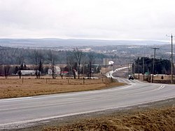
 Route 253 near Cookshire.


See also
[edit]References
[edit]- ^ Ministère des transports, "Distances routières", page 89, Les Publications du Québec, 2005
External links
[edit]- Route 253 on Google Maps
- Provincial Route Map (Courtesy of the Quebec Ministry of Transportation) Archived 2008-05-17 at the Wayback Machine (in French)
This Quebec road, road transport or highway-related article is a stub. You can help Wikipedia by adding missing information. |