Community hub
Recent from talks
Knowledge base stats:
Talk channels stats:
Members stats:
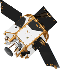
RazakSAT
RazakSAT was a Malaysian Earth observation satellite carrying a high-resolution camera. It was launched into low Earth orbit on 14 July 2009. It was placed in a near-equatorial orbit that presents many imaging opportunities for the equatorial region. It weighs over three times as much as TiungSAT-1 and carries a high-resolution Earth observation camera. Developed in conjunction with the Satrec Initiative, the satellite's low inclination (9 degrees) brought it over Malaysia a dozen or more times per day. This was intended to provide greatly increased coverage of Malaysia compared to most other Earth observation satellites. An audit report released in October 2011 revealed that the satellite had failed after one year of operation.
RazakSAT was the only operational satellite to be put into orbit by SpaceX's Falcon 1.
This satellite is Malaysia's second remote sensing satellite after TiungSAT-1.
Originally called MACSAT, RazakSAT's payload is mainly electro-optical, carrying a Medium-sized Aperture Camera (MAC) which is a pushbroom camera with five linear detectors (one panchromatic, four multi-spectral) weighing approximately 50 kg. The entire satellite weighs at about 180 kg.
SpaceX launched RazakSAT at 03:35 UTC on 14 July 2009 using a Falcon 1 rocket. This was the fifth flight of a Falcon 1, and like the previous flights lift-off was from Omelek Island in the Kwajalein Atoll. At 05:25 UTC Elon Musk, founder and CEO of SpaceX, told a reporter the launch had been a success. "We nailed the orbit to well within target parameters...pretty much a bullseye." Musk said.
RazakSAT's mission plan was carried out by engineers from Astronautic Technology Sdn Bhd (ATSB). This was especially important because Malaysia is usually covered by the equatorial cloud bands. Normal Sun-synchronous optical satellites, which may revisit an area only once every 7 days, will almost never be able to see the ground during their pass. As a result, much optical satellite imagery of Malaysia have more than 50% cloud cover within the image's footprint.
Razaksat, on the other hand, revisited some parts of Malaysian territory every 90 minutes, potentially maximising its ability to exploit gaps in the clouds.[citation needed]
RazakSAT, equipped with a high resolution Medium-Sized Aperture Camera (MAC), achieved the intended Near-Equatorial Low Earth Orbit (NEqO) at 685 km altitude and a 9 degree inclination. It was expected to provide high resolution images of Malaysia that can be applied to land management, resource development and forestry.
Hub AI
RazakSAT AI simulator
(@RazakSAT_simulator)
RazakSAT
RazakSAT was a Malaysian Earth observation satellite carrying a high-resolution camera. It was launched into low Earth orbit on 14 July 2009. It was placed in a near-equatorial orbit that presents many imaging opportunities for the equatorial region. It weighs over three times as much as TiungSAT-1 and carries a high-resolution Earth observation camera. Developed in conjunction with the Satrec Initiative, the satellite's low inclination (9 degrees) brought it over Malaysia a dozen or more times per day. This was intended to provide greatly increased coverage of Malaysia compared to most other Earth observation satellites. An audit report released in October 2011 revealed that the satellite had failed after one year of operation.
RazakSAT was the only operational satellite to be put into orbit by SpaceX's Falcon 1.
This satellite is Malaysia's second remote sensing satellite after TiungSAT-1.
Originally called MACSAT, RazakSAT's payload is mainly electro-optical, carrying a Medium-sized Aperture Camera (MAC) which is a pushbroom camera with five linear detectors (one panchromatic, four multi-spectral) weighing approximately 50 kg. The entire satellite weighs at about 180 kg.
SpaceX launched RazakSAT at 03:35 UTC on 14 July 2009 using a Falcon 1 rocket. This was the fifth flight of a Falcon 1, and like the previous flights lift-off was from Omelek Island in the Kwajalein Atoll. At 05:25 UTC Elon Musk, founder and CEO of SpaceX, told a reporter the launch had been a success. "We nailed the orbit to well within target parameters...pretty much a bullseye." Musk said.
RazakSAT's mission plan was carried out by engineers from Astronautic Technology Sdn Bhd (ATSB). This was especially important because Malaysia is usually covered by the equatorial cloud bands. Normal Sun-synchronous optical satellites, which may revisit an area only once every 7 days, will almost never be able to see the ground during their pass. As a result, much optical satellite imagery of Malaysia have more than 50% cloud cover within the image's footprint.
Razaksat, on the other hand, revisited some parts of Malaysian territory every 90 minutes, potentially maximising its ability to exploit gaps in the clouds.[citation needed]
RazakSAT, equipped with a high resolution Medium-Sized Aperture Camera (MAC), achieved the intended Near-Equatorial Low Earth Orbit (NEqO) at 685 km altitude and a 9 degree inclination. It was expected to provide high resolution images of Malaysia that can be applied to land management, resource development and forestry.